
***An active and cold weather pattern setting up for the second half of January across much of the northern US...extreme cold is on the table***
Paul Dorian
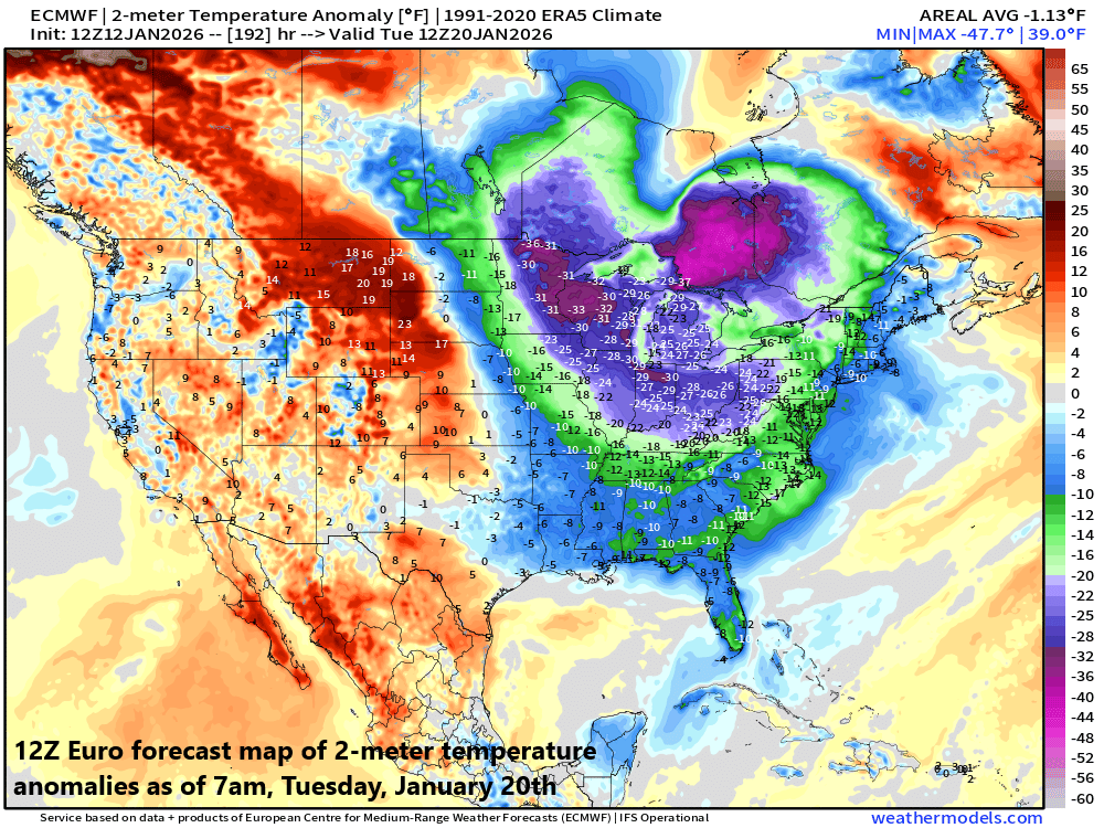
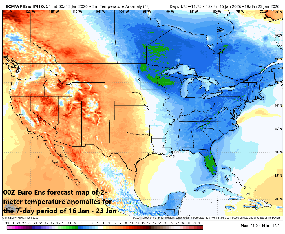
The overall pattern from mid-month on to at least early February looks to be colder-than-normal across much of the northern US and this can include some extremely cold air. In fact, there are some signs of brutal cold later this weekend and early next week; especially, across the Great Lakes, Upper Midwest and Ohio Valley where temperatures can reach far below-normal levels for this time of year. Map courtesy ECMWF, weathermodels.com (Dr. Ryan Maue, X)
Overview
After a couple of moderately cold days to start the week in the Mid-Atlantic region, it’ll turn milder on Wednesday ahead of the next cold frontal system. That mid-week cold front will usher in a colder air mass later this week, and it appears the overall weather pattern is setting up for multiple cold air outbreaks during the second half of January, and this will include the possibility of extreme cold.
In addition, the evolving weather pattern will likely be quite active as well featuring strong high pressure ridging near Alaska, high latitude blocking across northern Canada, and a large-scale and intense trough of low pressure centered over the eastern states. Multiple short-wave streams of energy will rotate through the large-scale trough, and each will have to be monitored to see if they can produce any appreciable snowfall in the Mid-Atlantic region.
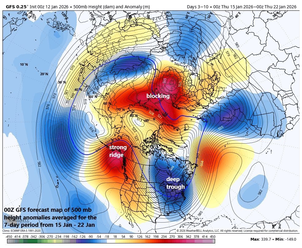
The overall pattern from later this week through much of next week looks to feature a deep trough centered over the eastern US, strong ridging near Alaska, and high-latitude blocking over the northern part of Canada. This kind of pattern in the upper part of the atmosphere can certainly lead to multiple cold air outbreaks from Canada into the US in coming days. Map courtesy NOAA, Weather Bell Analytics
Cold signals from numerous teleconnection indices...extreme cold on the table
The forecasted trends of numerous teleconnection indices tend to favor persistent colder-than-normal temperatures across much of the northern US during the second half of January. Specifically, trends into “negative” territory in coming days of indices such as the West Pacific Oscillation (WPO), East Pacific Oscillation (EPO), Arctic Oscillation (AO), and North Atlantic Oscillation (NAO) generally are correlated with colder-than-normal weather conditions this time of year from the Northern Plains to the Mid-Atlantic/Northeast US. When the WPO and EPO drop into “negative” territory in January that usually suggests an upper air pattern that features strong high pressure ridging across the northeastern Pacific and a trough of low pressure near the Hawaiian Islands. This combination usually inhibits the flow of mild Pacific Ocean air from ever making it into the western states - as was the case in recent days - and it also allows for the possibility of cold air intrusions into the northern US from way up in northwest Canada.
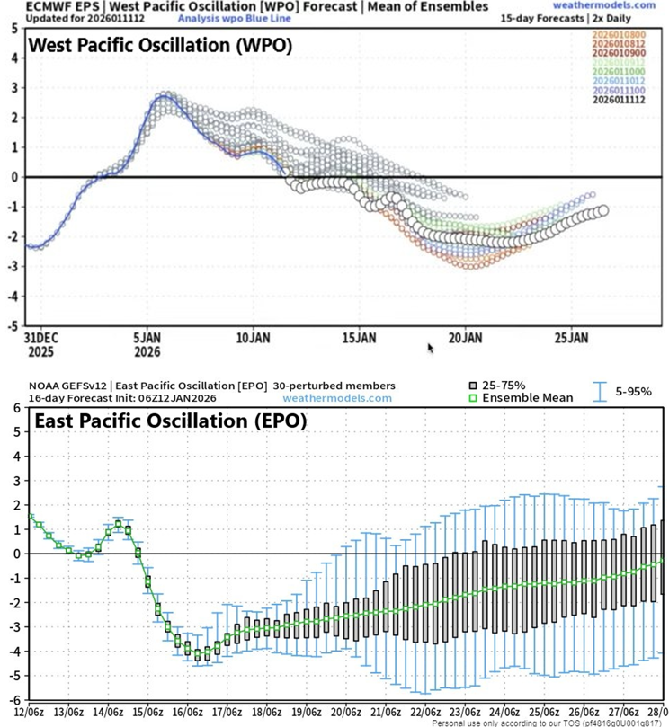
Both Pacific Ocean teleconnection indices, WPO (top) and EPO (bottom), trend into “negative” territory for much of the second half of January and this normally results in a “blocking” of mild Pacific Ocean air from ever making its way into the western US. Maps courtesy NOAA, ECMWF, weathermodels.com
When the AO and NAO teleconnection indices drop into “negative” territory this time of year, high-latitude blocking tends to form over northern Canada/Greenland, which, in turn, also favors the movement of cold air masses from way up in Canada into the northern US. Given the possibility of cold air intrusions into the US from way up in Canada, extreme cold is on the table for parts of the US and that risk can become reality as soon as this upcoming weekend and the early part of next week.
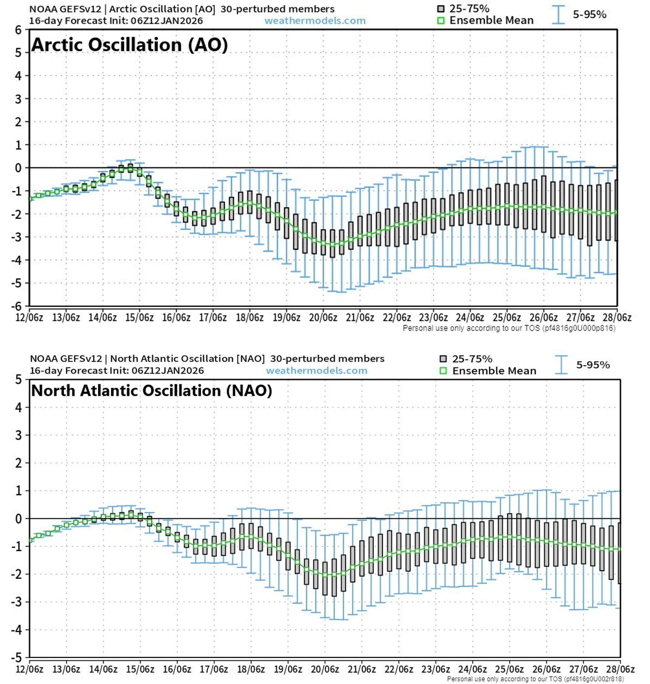
Both the Arctic Oscillation (AO, top) and North Atlantic Oscillation (NAO, bottom) trend into “negative” territory for much of the second half of January and this normally results in a “high-latitude blocking” situation which favors the transport of cold air masses from northern Canada into the northern US. Maps courtesy NOAA, weathermodels.com
An active pattern with multiple disturbances to monitor
While there is currently nothing on the weather maps that suggests a big snow is on the way to the Mid-Atlantic, the overall pattern will be quite active in coming days and each system will have to be closely monitored as small changes can have big impacts and there will be plenty of cold air around. A large-scale upper-level trough of low pressure will intensify over the eastern states later this week and numerous small-scale disturbances will rotate through it into at least the middle part of next week. By later Thursday, a northern stream short-wave is likely to merge with a southern disturbance, but likely not in time for any kind of significant snowfall in the DC-to-Philly-to-NYC corridor though some snow or snow showers are possible. Instead, the best chance for any significant snow on Thursday is likely to be confined to the far interior sections of the Mid-Atlantic region and Northeast US.
The overall weather pattern evolves into one that looks colder-than-normal across much of the eastern US from late this week through late next week with temperatures well below-normal for this time of year. Map courtesy ECMWF, Weather Bell Analytics
Over the upcoming weekend, additional short-waves of energy will drop south and east from Canada into the northern US, and these will have to be closely monitored to see they can help to spin up strong surface low pressure in time for any significant snowfall in the Mid-Atlantic region. Currently, odds are against it from happening, but there is still plenty of time for that threat to increase in what is a very complex overall pattern. Looking farther ahead, it is likely that additional waves of energy will rotate through the long-wave trough during the early-to-middle parts of next week and these too will need to be monitored with respect to their ultimate tracks and magnitude...stay tuned.
Meteorologist Paul Dorian
Arcfield
arcfieldweather.com
Video discussion: