
**Mild with PM showers on Friday...more widespread rainfall on Saturday and some of it can be heavy...turns windy, colder later Sunday into Monday...potentially wintry later next week/weekend**
Paul Dorian
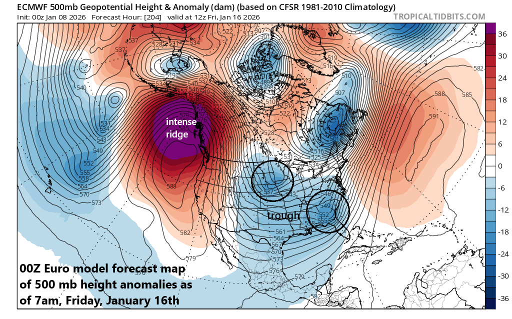
A big change in the upper air pattern will take place across the eastern Pacific Ocean by later next week as an intense ridge of high pressure will form and it could have significant implications downstream across the US in subsequent days. There will also be a large-scale trough of low pressure across the eastern half of the nation (shown in blue) with short-waves of energy (circled regions) rotating through…the interaction between the northern and southern stream systems will be crucial in the weather outcome for later next week across the northeastern states. Map courtesy NOAA, tropicaltidbits.com
Overview
Much warmer-than-normal air that originated over the Pacific Ocean has enveloped much of the nation this week and some of this will reach the northeastern states on Friday with high temperatures likely well up in the 50’s in many locations. It’ll turn out cooler on Saturday with a soaking rainfall, but still warmer-than-normal for this time of year. The milder weather will come to an end later this weekend with the passage of a strong cold front that’ll usher in colder and windy weather conditions for later Sunday into Monday.
By later next week, some important changes will begin to take place in the upper atmosphere across North America. First, an intense upper-level ridge of high pressure is likely to form near Alaska and the west coast of Canada replacing a trough of low pressure that has dominated that region in recent weeks. At the same time, an upper-level trough of low pressure will deepen over the eastern half of the US in response to a more active subtropical jet stream that has been largely missing in action in recent weeks. This combination will increase the chance for additional cold air intrusions into the US from Canada beginning later next week and can increase the chance for storms to develop across the southern and eastern states.
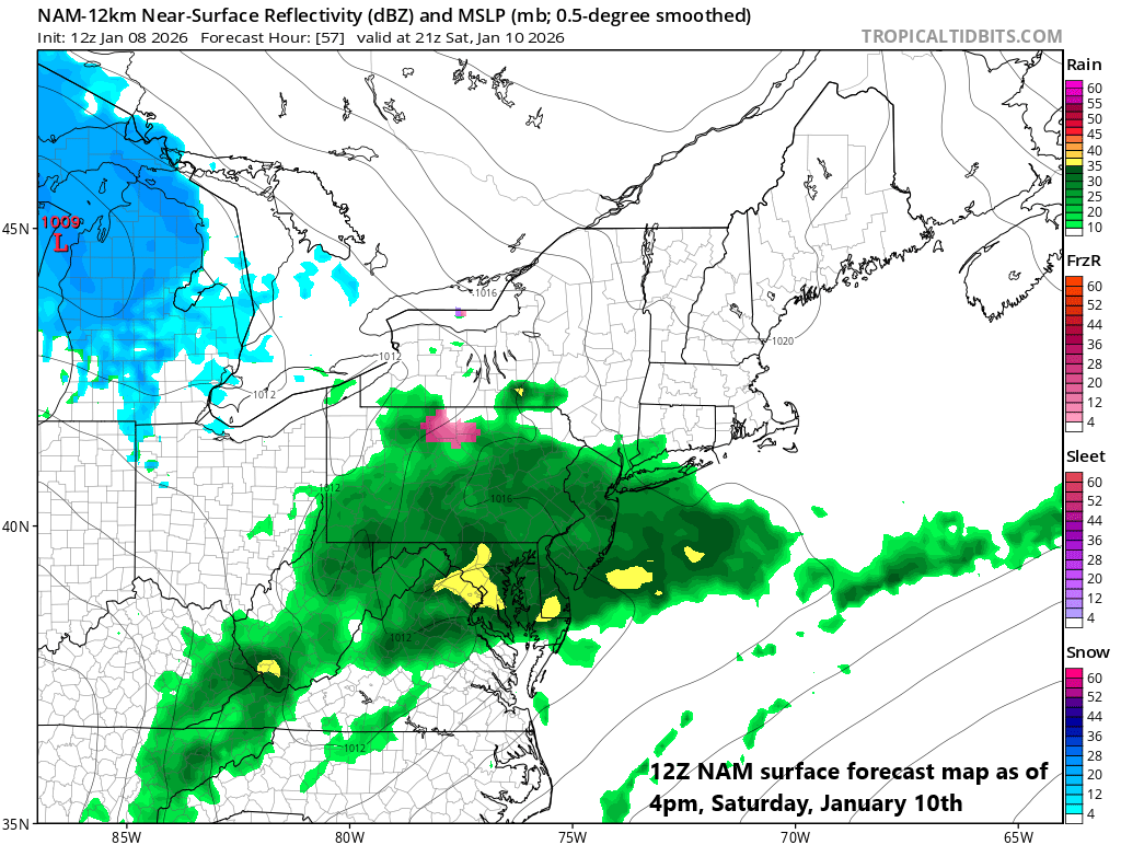
There will be periods of rain in the Mid-Atlantic region from late Friday night through Saturday and some of it can fall heavily at times. Map courtesy NOAA, tropicaltidbits.com
Details
Temperatures have climbed dramatically this week across much of the nation with an influx of air that pushed eastward from the relatively mild Pacific Ocean. While there has been a noticeable improvement in temperatures across the northeastern states during the past couple of days, the peak of this current warm-up will come on Friday in many spots. As an example, temperatures could climb to the upper 50’s for highs in Washington, D.C. on Friday afternoon and well up into the 50’s across the Philly and NYC metro areas. The overall weather pattern across the northeastern states had been colder-than-normal since around Thanksgiving Day and the month of December turned out to be the coldest since 2010 in many spots including Washington, D.C. and New York City.
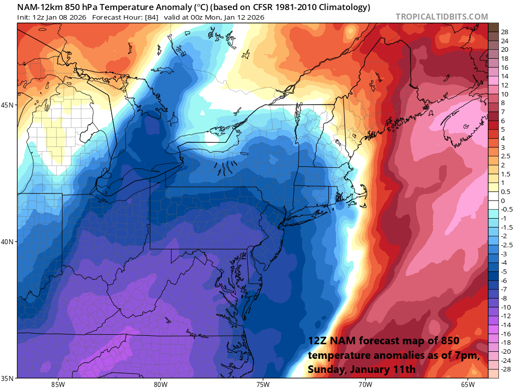
It turns colder and windy on Sunday behind after the passage of a strong cold front. Map courtesy NOAA, tropicaltidbits.com
The widespread warm-up will not come without some of its own problems, however, as heavy rain and localized flooding will be on the table from late Friday into Saturday across the Tennessee Valley and Lower Mississippi Valley. In fact, there can even be some strong-to-severe thunderstorm activity in this part of the country and 3+ inches of rain can fall in some spots. The peak of the warm-up will be rather wet in the Mid-Atlantic region as well with occasional showers on Friday afternoon and then periods of rain from late tomorrow night through Saturday and some of this can be heavy at times. A cold front pushes across the region on Saturday night and its passage will usher in a cooler air mass and then a secondary cold front arrives later in the day on Sunday. This second cold front will be the trigger mechanism for an increase in winds later on Sunday (from a northwesterly direction) and it’ll turn even colder for Monday as we begin the new work week (expect windy, cold conditions for the Eagles playoff game late Sunday afternoon).
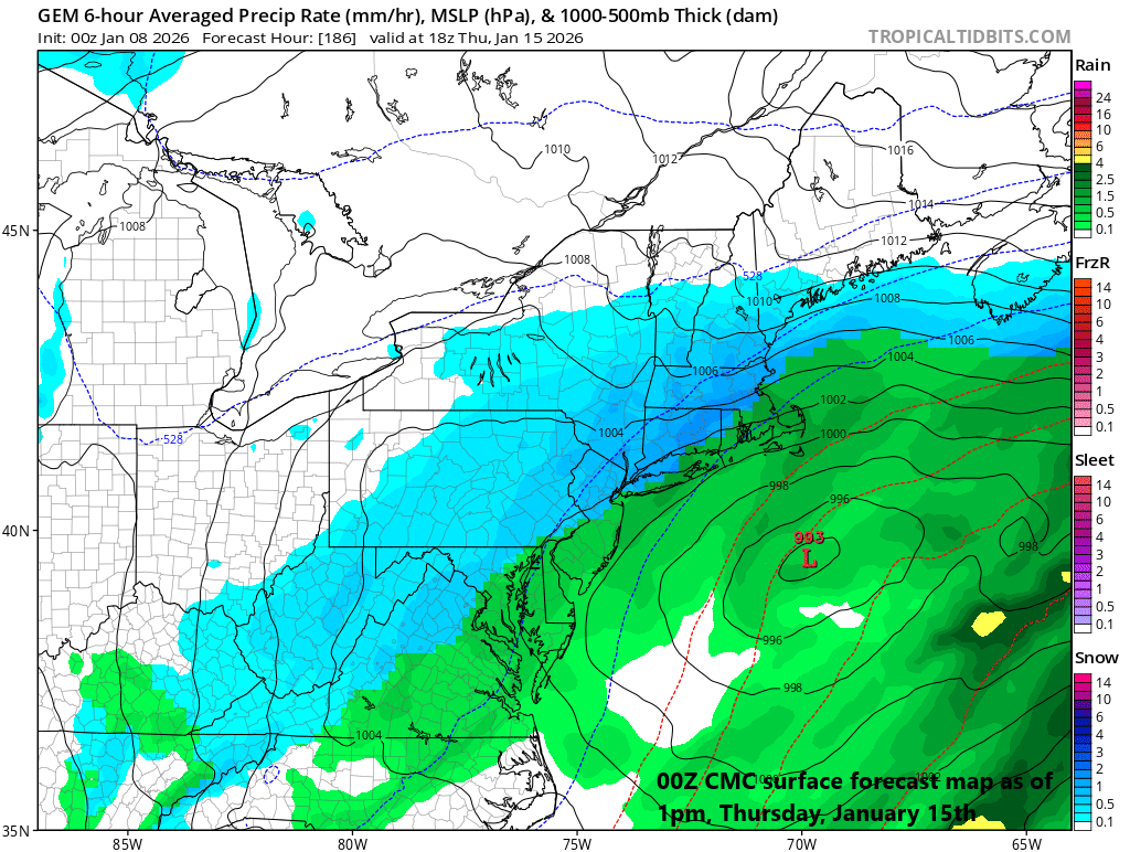
By later next week, there is the chance for some snow across the Mid-Atlantic region and Northeast US…it’ll all depend on the interaction between northern and southern branch waves of energy in an upper-level large-scale trough…stay tuned. Map courtesy Canadian Met Centre, tropicaltidbits.com
By later next week, the overall upper-air pattern over North America will evolve to one that features an intense high-pressure ridge centered near Alaska and the west coast of Canada, and this location of the ridge will likely inhibit mild Pacific Ocean air from pushing eastward into the western US. At the same time this “Alaska ridge” begins to form late next week, a large-scale upper-level trough of low pressure will intensify over the eastern half of the US. Multiple short-waves will rotate through this large-scale upper-level trough including one in the northern (polar) jet stream and one in the southern (subtropical) jet. The interaction between the northern and southern waves of energy will dictate if a storm can intensify and ride up along or near the eastern seaboard later next week or if anything that forms would go out-to-sea. If this late week storm threat does not materialize then the unfolding upper air pattern would likely generate other opportunities for snow in the northeastern states during the following weekend and third week of January...stay tuned, winter is about to make a return.
Meteorologist Paul Dorian
Arcfield
arcfieldweather.com
Follow us on Facebook, Twitter, YouTube
Video discussion: