
**It’s déjà vu all over again...monitoring another late weekend storm threat for the Mid-Atlantic region...ultimate track and impact still in question**
Paul Dorian
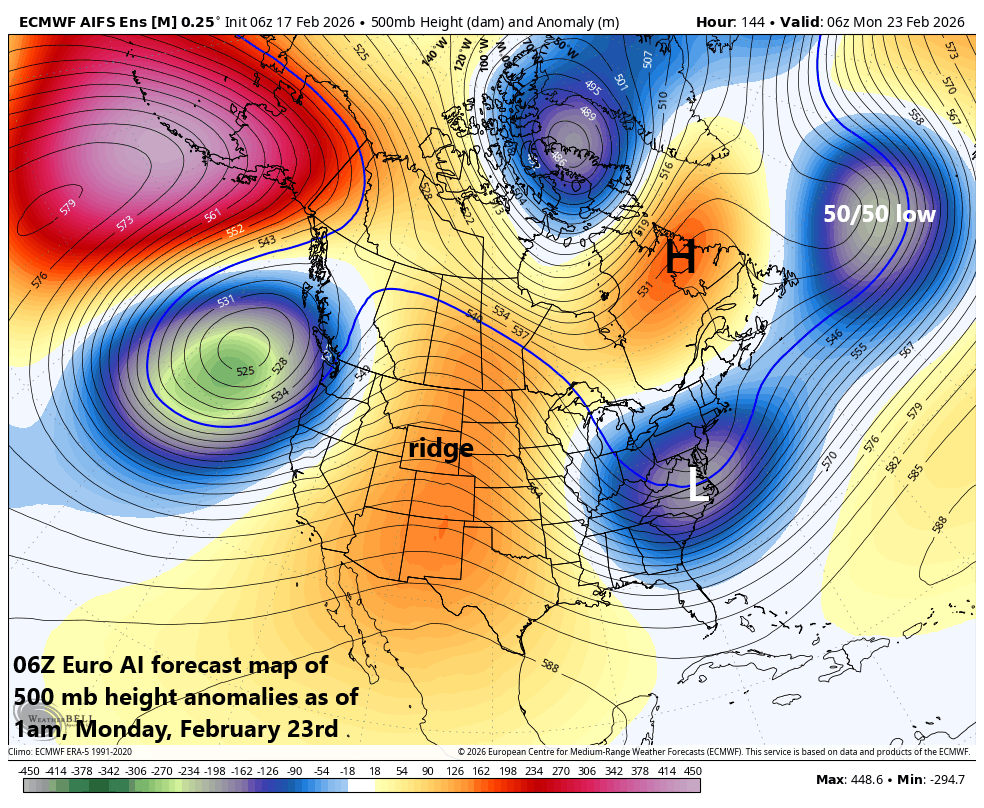
The Euro AI forecast map of 500 mb height anomalies as of late Sunday night with low pressure centered near the Mid-Atlantic coastline, some blocking to the north over eastern Canada, and an upper-level ridge across the interior west…some of the key players to monitor during the next few days. Map courtesy ECMWF, Weather Bell
Overview
This may sound familiar, but there is the chance that a storm system will travel eastward this weekend from the Deep South to the east coast, and it could threaten the Mid-Atlantic region with snow, ice and/or rain. The overall weather pattern will be quite active for much of the country in coming days with multiple storm systems to deal with and impacts from coast-to-coast. One storm system came ashore on Monday along the California coast, and it will push to the Colorado Rockies by the middle of the week. At the same time, a frontal boundary zone will start to set up from the Northern Plains to the northeastern states, and it will be the focus area for multiple disturbances leading to some snow and ice on its northern side and rain to the south.
By the early part of the weekend, another storm system will begin to take shape over the south-central US with its moisture field starting to expand. Much like the scenario that played out last weekend, this low pressure system will trek in a general eastward direction - riding along the subtropical jet stream - and potentially can reach the Mid-Atlantic coastline by late Sunday. With cold air in place and support in the upper atmosphere, this system could intensify at that point and become a threat for accumulating snow in at least portions of the Mid-Atlantic region by the latter part of the weekend.
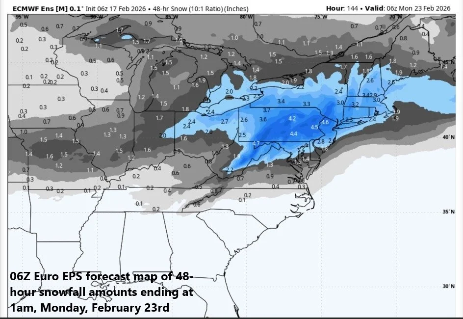
An early look at snowfall estimates by the 06Z run of the Euro ensemble model for the potential late weekend storm system. Map courtesy ECMWF, Weather Bell
Details
The subtropical jet stream has become much more active in recent days leading to a change in the overall pattern that will produce much in the way of precipitation for the western US where it has been quite dry. The precipitation will come in the form of rain for low lying areas and snow is likely to become substantial for some of the higher elevation locations in the western US. As an example, several feet of snow are likely to pile up in the Sierra Nevada Mountains of eastern California making up for some lost time during the recent dry spell and snow should accumulate in higher elevation locations all the way to the Colorado Rockies...a great pattern for skiers in the western states.
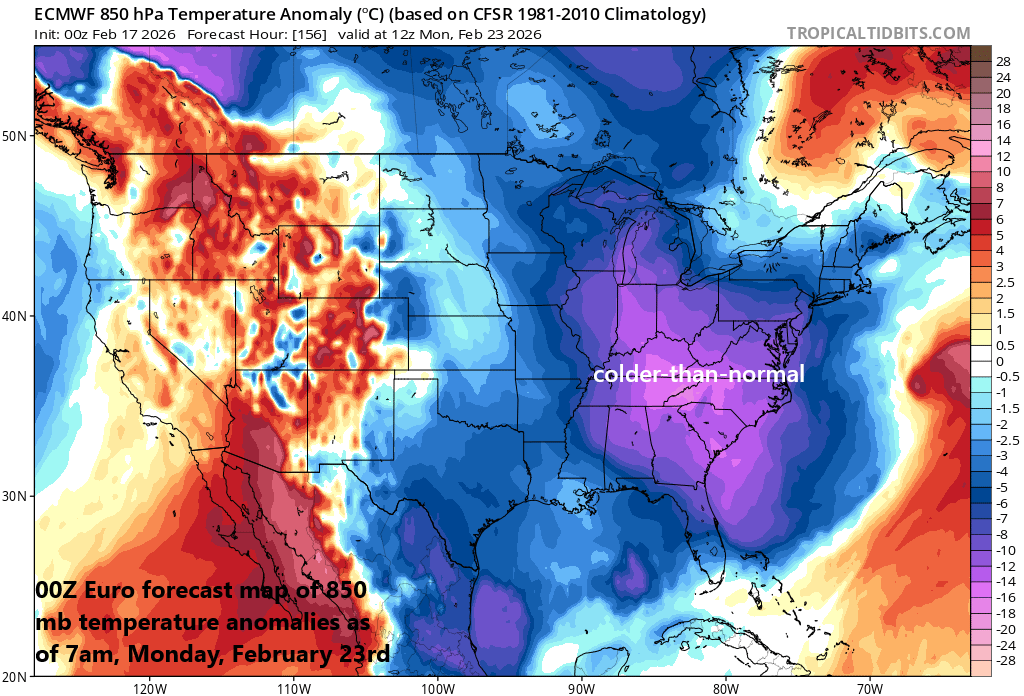
On the heels of the late weekend storm, another colder-than-normal air mass will flood the eastern states and winds will likely be quite strong as well. Map courtesy ECMWF, tropicaltidbits.com
As was the case last weekend, some energy from the western storm system is likely to spill out over the south-central states after its trek across the Rocky Mountain States and moisture will tend to expand in nature by the early part of the upcoming weekend. With the subtropical jet generally flowing in a west-to-east fashion across the southern states, this unfolding area of low pressure is likely to push eastward towards the Mid-Atlantic coastline where it may reach later in the day on Sunday.
At this point, there is going to be the chance for significant intensification if there is a “phasing” together of this southern stream of energy with a second wave of energy riding along the polar jet to the north. The timing of the “phasing” is one of the questions that will have to answered in coming days and the precipitation type will be location dependent and better predicted in coming days as well with snow/ice favored across the northern sections and plain rain in the southern part.
Stay tuned...another late weekend storm threat for the Mid-Atlantic region and lots of details to iron out…ultimate track and impact still in question this far out.
Meteorologist Paul Dorian
Arcfield
arcfieldweather.com
Follow us on Facebook, Twitter, YouTube
Video discussion: