****Closely monitoring late weekend storm threat for the Mid-Atlantic region...a possible important factor that can influence storm track...and an inverted trough****
Paul Dorian

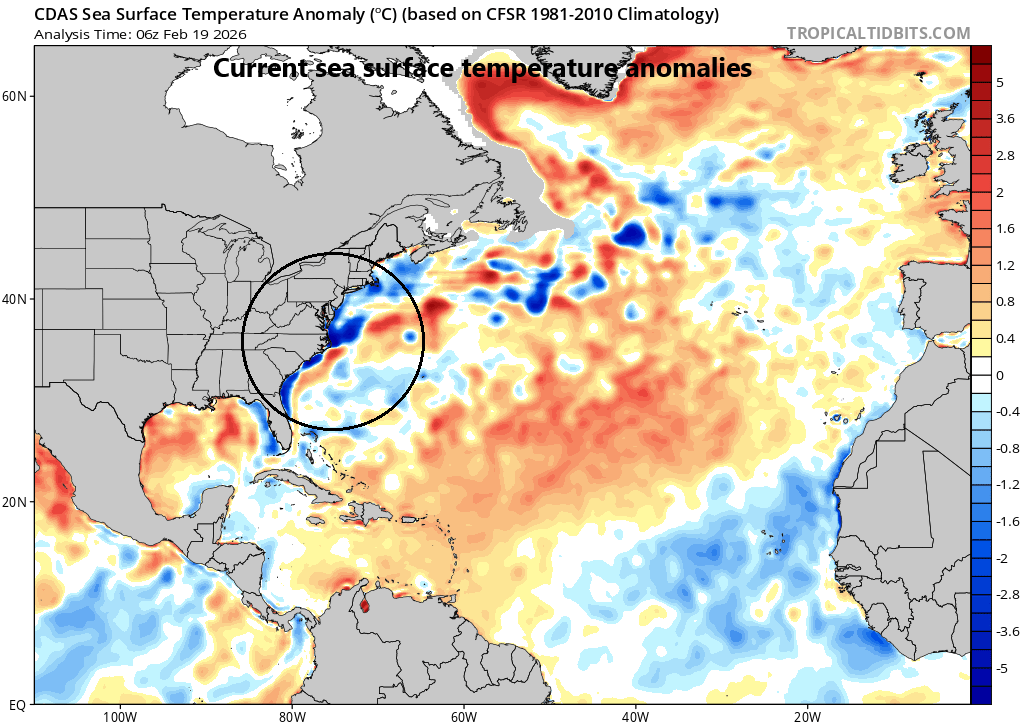
An important factor to the ultimate track of the late weekend storm system may be the temperature gradient in the western Atlantic Ocean. The sharpest gradient appears to be in the region off the North Carolina coastline where colder-than-normal water on the northwestern side (Labrador current) clashes with warmer-than-normal (Gulf stream) water on the southeastern side (circled region). Low pressure systems tend to favor movement along temperature gradient zones which, in this case, would suggest an east-to-northeast push from North Carolina to out over the western Atlantic rather than “hugging the coastline” farther to the north. Map courtesy NOAA, tropicaltidbits.com
Overview
Low pressure will intensify significantly later Sunday somewhere over the western Atlantic Ocean and it can produce rain and accumulating snow inland to the I-95 corridor. The greatest impact from the late weekend storm may come in coastal sections from New Jersey to the Delmarva Peninsula to the eastern part of Virginia, still a few days away to fine-tune this idea. Two important details that have to be ironed out involve the ultimate storm track and the timing of the rapid intensification. Does the storm system hug the coast or push east-to-northeast out over the western Atlantic? Does the storm system intensify rapidly right near the coast or out over the western Atlantic? The multiple waves of energy that will be critical players in this unfolding scenario will come into better focus during the next couple of days. Another important factor that can play a role in the ultimate track of the late weekend storm system is the sea surface temperature pattern near the eastern seaboard with a sharp gradient off the North Carolina coastline.
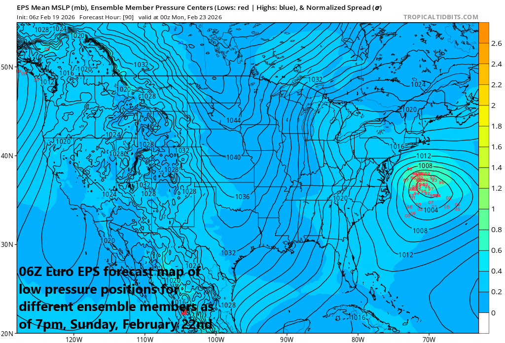
The Euro model places most “ensemble” member low pressure locations over the temperature gradient region of the western Atlantic Ocean by Sunday evening, February 22nd, rather than “hugging the coastline” farther to the north as NOAA’s GFS model continues to do. Map courtesy ECMWF, tropicaltidbits.com
Details
Unsettled weather continues in the Mid-Atlantic region during the next couple of days with periods of rain likely from later today through tomorrow morning all along the DC-to-Philly-to-NYC corridor. It may become cold enough for some ice pellets and/or snow to mix in at times in areas to the north of around I-80 such as east-central/northeastern PA, as well as across interior NW NJ, and the NYC metro region. The weekend will then begin with some clearing in the Mid-Atlantic region and relatively mild conditions.
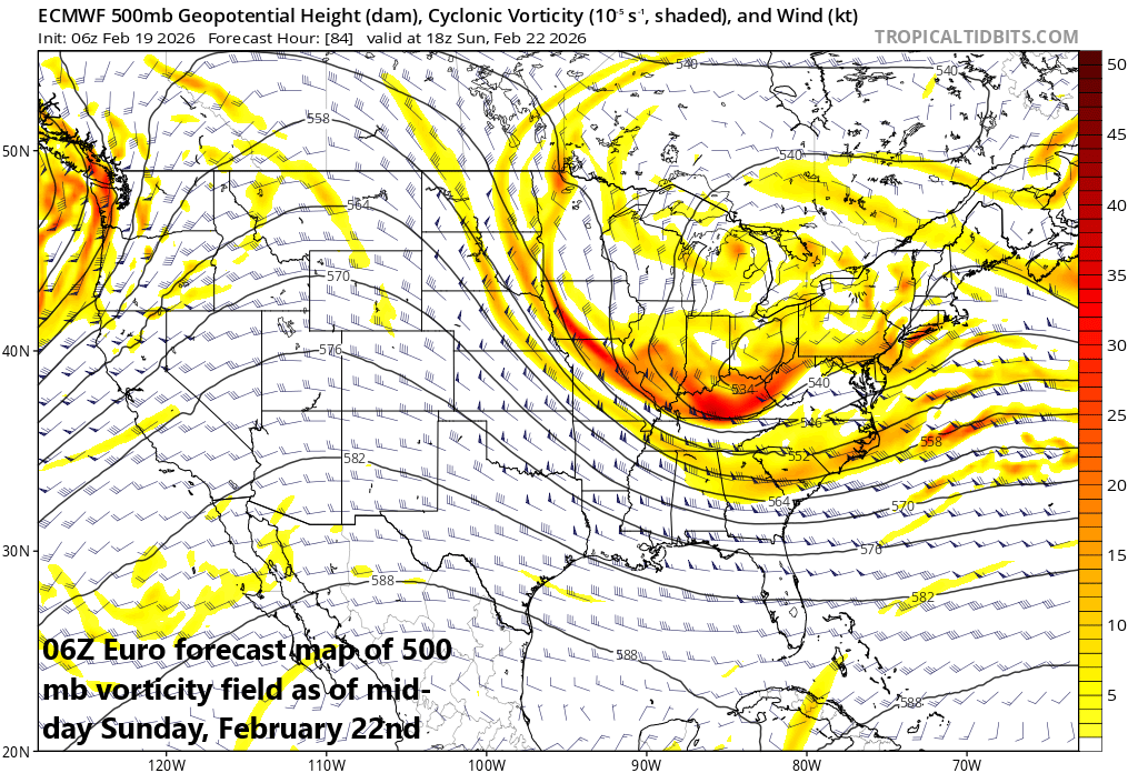
ECMWF’s Euro model has been less “bullish” on an impactful late weekend storm system in the Mid-Atlantic region; especially, in comparison with NOAA’s GFS, and a look at the 500 mb vorticity provides some reasoning as to the reasons behind this difference. The Euro model has more of a “stretched-out” vorticity field which results in slower and less intensification of the surface low pressure system when compared to the NOAA GFS model. Map courtesy NOAA/tropicaltidbits.com
By early Sunday, all eyes will begin to focus on the southeastern states where low pressure will begin to develop. This system will head towards the Carolina coastline and intensification is likely to take place as waves of energy aloft begin to “phase” together. This intensifying low will then move to a position somewhere over the western Atlantic Ocean and can produce rain and accumulating snow inland to the I-95 corridor. A rapid intensification on Sunday and a storm track close to the coast would likely result in a major winter storm for the immediate I-95 corridor whereas a later intensification and an “east-to-northeast” movement to a position out over the western Atlantic Ocean would likely limit impacts in the big cities.
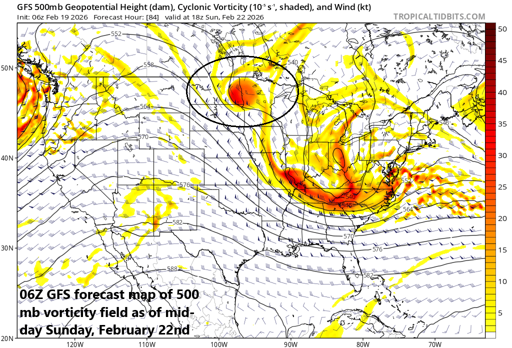
NOAA’s GFS model has been more “bullish” on an impactful late weekend storm system in the Mid-Atlantic region; especially, in comparison with the Euro, and a look at the 500 mb vorticity provides some reasoning as to why the difference. The GFS holds back the northern wave of energy (circled) area and has a better defined frontrunning system allowing for a deeper and more rapid intensification of the surface low when compared to the Euro. Map courtesy NOAA/tropicaltidbits.com
At this point, it appears that there will be some impact to the big cities along the I-95 corridor – probably a rain changing to accumulating snow scenario – and the potential still exists for a significant event. One of the features that makes it a high probability of accumulating snow in the I-95 corridor is an inverted trough that should develop on Sunday. The greatest impact from this late weekend storm system may be along coastal sections from New Jersey to the Delmarva Peninsula to the eastern part of Virginia where winds have a better chance of being quite strong and overall precipitation amounts can be heavy. The timing of the intensification of the surface low will depend upon the interaction of multiple waves of energy in the upper part of the atmosphere. A quick “phasing” together of these waves would produce rapid intensification near the east coast and likely a higher chance of significant impacts in the I-95 corridor. A slower “phasing” together of these waves aloft would cause the most intensification farther out-to-sea and likely a reduced impact in the big cities. These waves of energy will be better sampled by radiosonde data during the next day or so which should shed some more light on the eventual solution.
In addition to the waves of energy aloft, sea surface temperatures may play an important role in the ultimate track of the storm system. There has been a persistent narrow pool of colder-than-normal water sitting right near the east coast and the temperature gradient between the Gulf (warm) stream and Labrador (cold) current has been pushed farther to the south compared to normal to a position off the North Carolina coastline. Low pressure systems tend to favor movement along temperature gradient zones which, in this case, would be somewhere to the east/northeast of the North Carolina coastline as opposed to farther to the north nearer to the Delmarva Peninsula coastline. This idea argues for less of an impact in the big cities as suggested by recent Euro model runs compared to the “hug the coast” scenario as suggested by recent GFS model runs ...we’ll see how this plays out.
Stay tuned...the next couple of days will be critical in the analysis of the late weekend storm threat for the Mid-Atlantic region and a significant event is still on the table for the big cities. One last note, no matter what happens with respect to the late weekend storm system, there will be an influx of much colder-than-normal air into the eastern states early next week and this next shot of cold air will (once again) impact areas all the way down to Florida.
Meteorologist Paul Dorian
Arcfield
arcfieldweather.com
Follow us on Facebook, Twitter, YouTube
Video discussion: