
*****Significant snowstorm for the DC-to-Philly-to-NYC corridor...low pressure to intensify off Mid-Atlantic coastline...likely timetable of Sunday AM to Monday AM*****
Paul Dorian
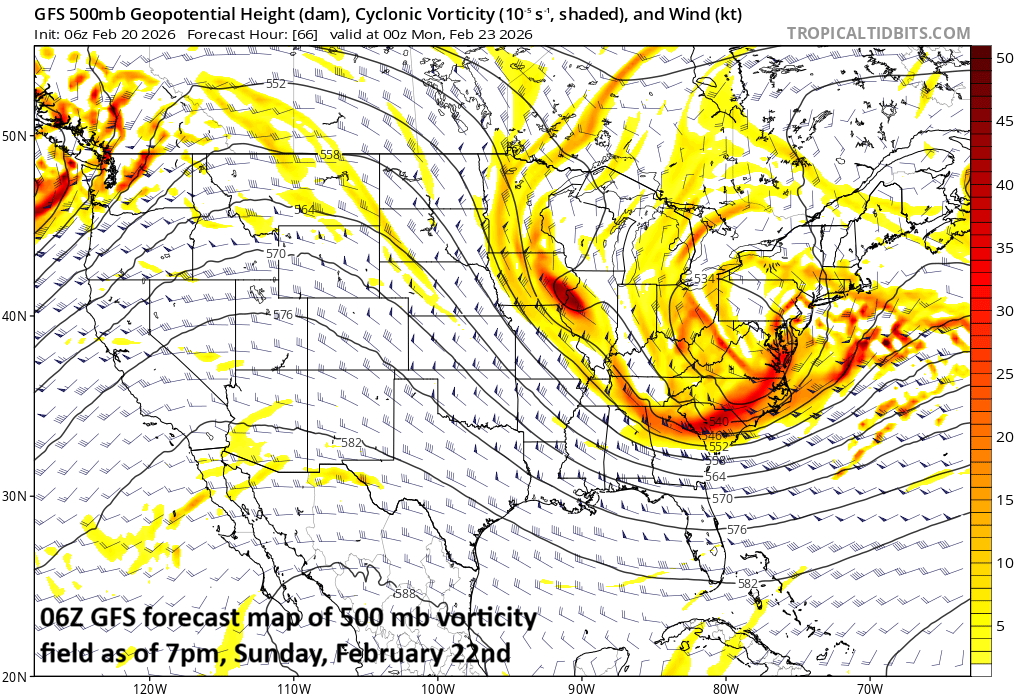
A key player in the likely rapid intensification of a late weekend storm system will be the “negative-tilt” to an upper-level trough which will enhance upward motion at surfaces levels in the Mid-Atlantic region. Map courtesy NOAA, tropicaltidbits.com
Overview
Significant snowstorm for the DC-to-Philly-to-NYC corridor…
Low pressure will intensify rapidly later Sunday over the western Atlantic Ocean, and it is very likely to produce accumulating snow in the DC-to-Philly-to-NYC corridor with significant amounts of 6-12+ inches on the table. The precipitation may begin as rain or a mix of rain and snow on Sunday morning/midday before changing to all snow by later in the day and the snow can come down heavily at times from late Sunday into Monday morning…potentially leading to big-time travel disruptions for the Monday morning commute. The storm will intensify rapidly as upper-level support takes on a “negative tilt” and enhances upward motion at surface levels in the Mid-Atlantic region. The possibility of a significant snow event in the Mid-Atlantic’s I-95 corridor will largely depend on the ultimate track of the storm with a “hugging” of the coast more favorable for highest accumulation amounts…this scenario is looking increasingly likely. Farther up the I-95 corridor, a significant snowstorm is also quite likely across southern and eastern New England including the Boston metro. On the heels of the storm, a very cold air mass will flood much of the eastern US during the early part of next week.
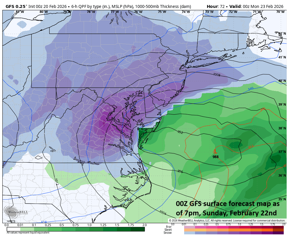
Low pressure will intensify over the western Atlantic Ocean by the end of the weekend and it can result in a significant snow event for the DC-to-Philly-to-NYC corridor if it hugs the coastline rather than moving farther out-to-sea. Map courtesy NOAA, Weather Bell
Details
Unsettled weather continues today in the Mid-Atlantic region with periods of rain associated with a nearby frontal boundary. After some clearing skies late tonight, the weekend will begin with some sunshine in the Mid-Atlantic region and relatively mild conditions. By early Sunday, all eyes will begin to focus on the Carolina coastline where low pressure will begin to develop. This system will head to the open waters of the western Atlantic Ocean and undergo rapid intensification as upper-level energy takes on a “negative tilt” enhancing upward motion in the Mid-Atlantic region. This intensifying low over the western Atlantic Ocean will likely feature an inverted trough that extends inland from its center enhancing the chance for accumulating snow across interior sections of the Mid-Atlantic region including the I-95 corridor.
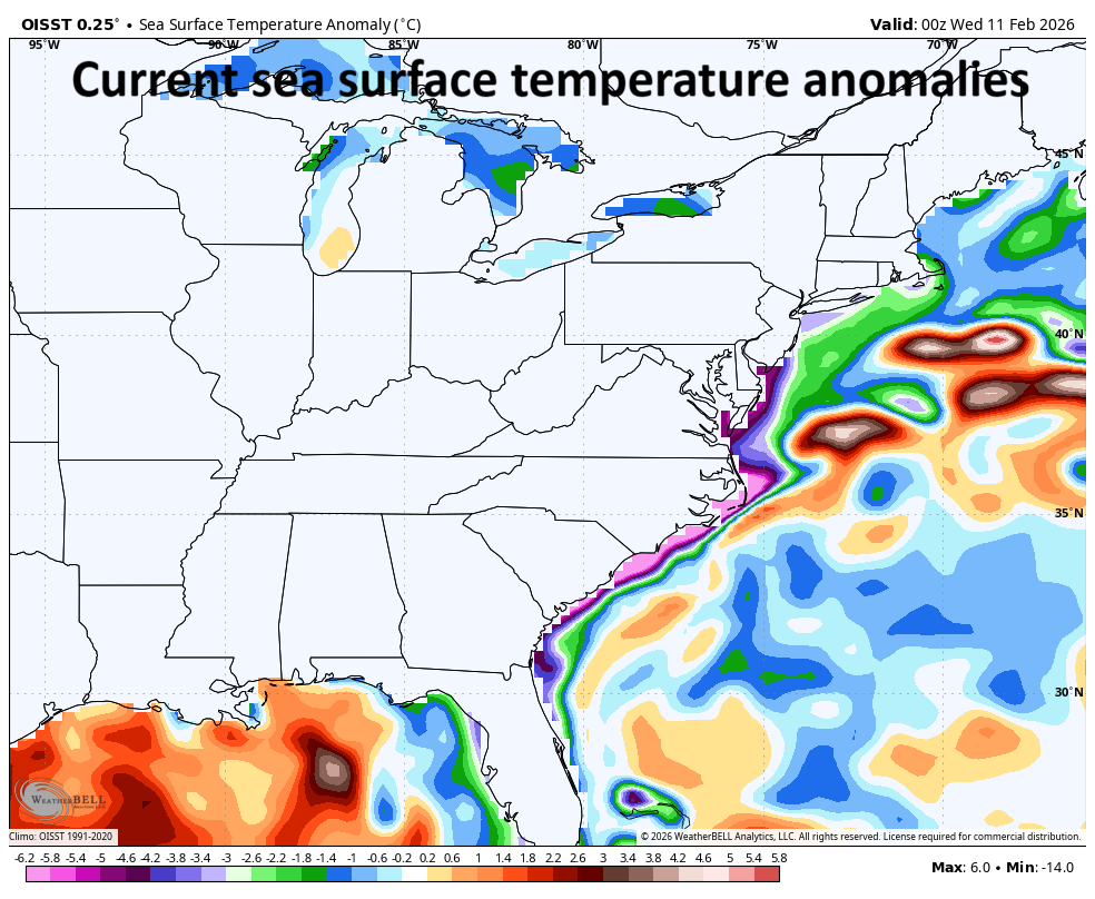
There are two noticeable blobs of warmer-than-normal water off the east coast and this late weekend storm system could very well trek from one to the other. Map courtesy NOAA, Weather Bell
Precipitation is likely to break out during the morning/mid-day hours on Sunday, and it can be in the form of rain or a mix of rain and snow along the I-95 corridor before changing to all snow by later in the day. Snow is likely from late Sunday into Monday morning, and it can be heavy at times, potentially leading to big-time travel disruptions for the Monday morning commute. Final accumulation amounts will ultimately depend on the track of the storm, and a significant snow event of 6-12+ inches remains likely for the I-95 corridor as there is an increasing likelihood that the system “hugs the coast” rather than pushing out-to-sea (this favors heavier snow). Winds are likely to gusts to the 30-40+ mph range during this storm system in the immediate DC-to-Philly-to-NYC corridor considering the significant intensification that is likely to take place over the western Atlantic Ocean. Along coastal sections from Long Island to NJ to the Delmarva Peninsula to eastern Virginia, winds can become especially impactful with gusts likely reaching at least the 40-50+ mph range.
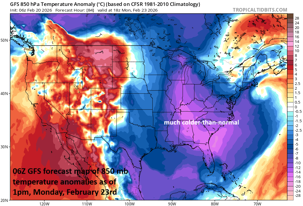
No matter what happens with the late weekend storm system, a much colder-than-normal air mass will follow into the eastern states for the early part of next week with an impact all the way down to the state of Florida. Map courtesy NOAA, tropicaltidbits.com
Following the storm, a much colder-than-normal air mass will flood the eastern states and temperatures will drop to well below-normal levels all the way down to the state of Florida. In fact, the coldest core of this incoming air mass – relative to normal - will end up in the TN Valley/Southeast US during the early part of next week.
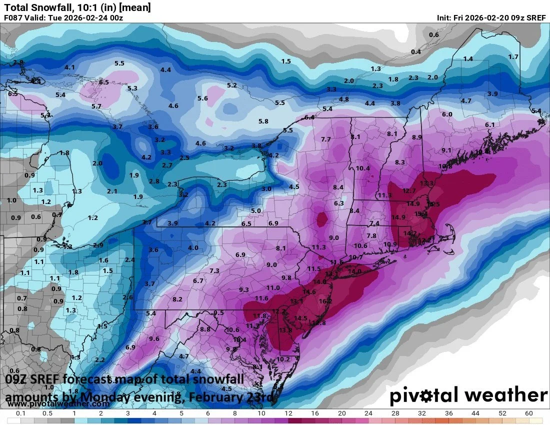
Snowfall can be significant in the DC-to-Philly-to-NYC corridor from later Sunday into early Monday with 6-12 inches on the table and potentially even higher snowfall amounts. Map courtesy NOAA, Pivotal Weather
Stay tuned to arcfieldweather.com…still a couple of days before event time and final details must be ironed out.
Meteorologist Paul Dorian
Arcfield
arcfieldweather.com