
****Multiple systems to deal with...snow/rain threat on Thursday...accumulating snow threat early next week...warm-up late next week and a significant stratospheric polar vortex split****
Paul Dorian
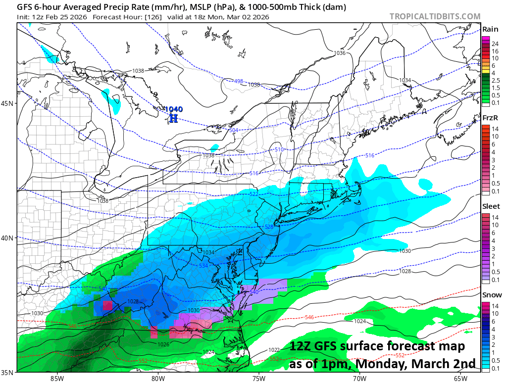
The setup could be ideal on Monday for some accumulating snow in the Mid-Atlantic region with strong, cold high pressure to the north and low pressure moving west-to-east along a frontal boundary zone. Map courtesy NOAA, tropicaltidbits.com
Overview
An active weather pattern brought a clipper system to the north of the Mid-Atlantic region today with a bit of snow in some areas just in time for the morning commute. Another low-pressure system will take the southern route on Thursday, and some snow and/or rain will be possible in the DC-to-Philly-to-NYC corridor. Another low-pressure system (or two) can impact the Mid-Atlantic region during the early and middle parts of next week and with strong, cold high pressure stationed to the north, frozen precipitation is favored with accumulating snow on the table in some areas.
Looking beyond the early-to-mid week winter weather threats, a noticeable warmup is likely to take place in the Mid-Atlantic region by the end of next week and the warmup can very well last through the second week of March. In fact, temperatures could climb into the 60’s by late next week in portions of the southern Mid-Atlantic region (e.g., Washington, D.C.) and the 50’s are possible in the northern Mid-Atlantic (e.g., Philly, NYC) and it could turn even milder than that during the second week of March. This potential warmup may not be the end of the colder-than-normal weather; however, as there are strong signs for another significant stratospheric warming event to take place by late next week. This potential polar vortex split can bring a return of colder-than-normal weather conditions to the eastern states from around the middle of March to the middle of April.
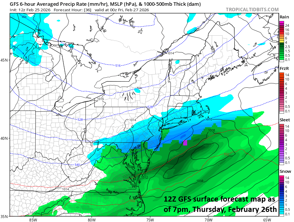
Low pressure will take a southern track on Thursday it can produce some snow and/or rain in the Mid-Atlantic region with small accumulations on the table. Map courtesy NOAA, tropicaltidbits.com
Thursday threat
An ongoing active weather pattern brought a clipper low pressure system well to the north of the Mid-Atlantic region on Wednesday, and it was able to generate a bit of snow in some areas with a dusting or so just in time for the AM commute. Another low-pressure system will take a southern route on Thursday and while it has more available moisture than the clipper, its impact on the DC-to-Philly-to-NYC corridor may be somewhat limited as we’ll be on its northern fringes and temperatures will be borderline. Nonetheless, we’ll have to monitor the progression of tomorrow’s system and small snow accumulations are on the table in at least parts of the Mid-Atlantic region. The couple of days to follow tomorrow’s threat should generally be dry in the Mid-Atlantic region with chilly conditions on Friday and then noticeably milder weather on Saturday.
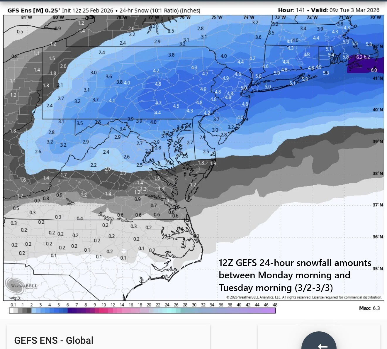
The 12Z ensemble run of the GFS features appreciable amounts of snowfall in the Mid-Atlantic region for the early part of next week. Map courtesy NOAA, Weather Bell
Early next week accumulating snow threat
By the early part of next week, a strong frontal boundary zone will set up in a west-to-east fashion across the northern states, and this could lead to interesting weather around here. By Monday, the west-to-east frontal boundary zone might be the perfect conduit for low pressure to ride along, and, at the same time, strong, cold high pressure will set up across the Northeast US. This could end up being an ideal setup for accumulating snow and/or ice in at least some parts of the Mid-Atlantic region during the early part of next week, and a second system could follow on Tuesday or Wednesday. By the time the second system arrives, the cold air mass across the northeastern states could be in retreat mode so frozen precipitation may be somewhat less of a threat than with the initial system on Monday...stay tuned.
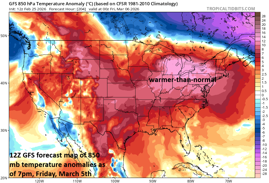
A big-time warmup is possible in the Mid-Atlantic region by later next week and the warmup could actually intensify during the second week of March. Map courtesy NOAA, tropicaltidbits.com
Warmup late next week and likely through the second week of March
Looking beyond the potential early/mid-week winter weather threats, there are signs for a significant warmup in the eastern states by the end of next week. Warmer air, which has been confined to the middle of the country in recent days, will make a strong push to the northeast, and it should be able to penetrate the Mid-Atlantic region with the 60’s a possibility by late next week in places like Washington, D.C. In fact, the potential big-time warm-up in the eastern states that begins late next week could very well last right through the second week of March and intensify; however, this may not be the end of the colder-than-normal weather for this part of the nation.
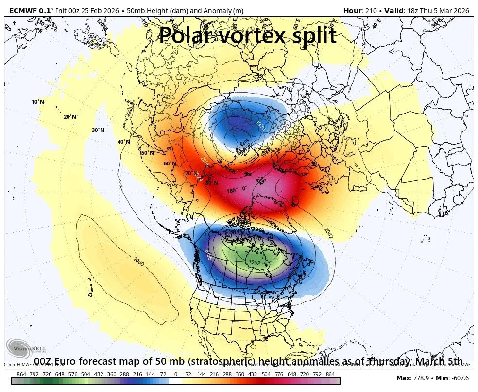
A stratospheric polar vortex split could take place by the end of next week and it can result in a return to colder-than-normal conditions from mid-March to mid-April in the eastern states after a big-time warmup later next week and the second week of March. Map courtesy ECMWF, Weather Bell
Stratospheric polar vortex split
At the same time the eastern states experience a big-time warmup, another significant stratospheric warming event may unfold over the polar Northern Hemisphere. Specifically, it appears there will be a stratospheric polar vortex split by the end of next week with one part re-positioned over Canada and a second part ending up on the other side of the North Pole over the Asian continent. In between these two areas, there will be a region of higher heights (and stratospheric temperatures) somewhere right near the North Pole. According to meteorologist Joe Bastardi, there have been only three occasions in recent history with such a significant stratospheric polar vortex split during the first half of March. These three took place in 2018, 2013, and 1984 and in all these years, there was a very cold period in the eastern states from around the middle of March to the middle of April...we’ll see how this one plays out.
Meteorologist Paul Dorian
Arcfield
arcfieldweather.com
Follow us on Facebook, Twitter, YouTube
Video discussion: