
***An active Arctic frontal passage late Friday...some snow, maybe a few squalls...direct discharge of bitter cold Arctic air for the weekend with origins in Siberia...powerful winds of 50+ mph***
Paul Dorian
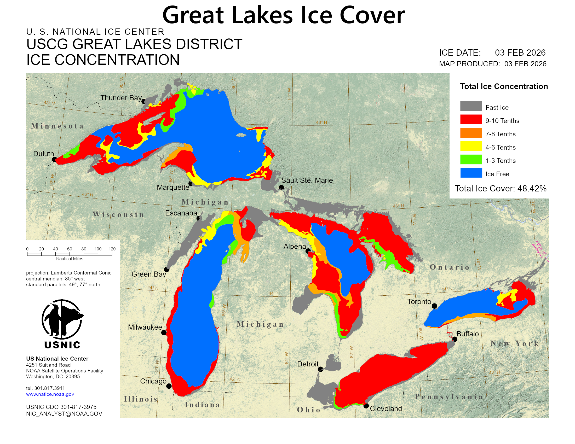
The Great Lakes are well above the historical averages in terms of ice concentration with about half being covered as of early February. Lake Erie is the shallowest of the Great Lakes and is about 95% ice covered and Lake Huron has the second highest ice concentration of 77%. Normally, Arctic air that pushes into the northeastern states moves here by crossing the Great Lakes in a northwest-to-southeast fashion and this results in some modification of the air mass. In this weekend’s scenario, the chances for modification will be limited as the Arctic blast will come from the north…directly discharged to us from the frozen tundra region of eastern Canada. Map courtesy NOAA
Overview
An Arctic air mass is headed to the Mid-Atlantic/Northeast US for the weekend with its origins on the Siberian side of the North Pole. This Arctic blast will be directly discharged to us from eastern Canada as compared with the more conventional “northwest-to-southeast” route that travels over the Great Lakes. The cold front at the leading edge of this bitter cold air mass will be quite active with strong support in the upper part of the atmosphere, likely leading to some accumulating snow on Friday afternoon and evening, and perhaps a few snow squalls will mix into the picture. In addition to the bitter cold, biting and potentially damaging winds will become a major factor on both weekend days with gusts of 50+ mph producing dangerously low wind chill levels of well below zero in many locations.
The invasion of Arctic air into the Mid-Atlantic/NE US this weekend will come from the north…this “direct discharge” of Arctic air from the frozen tundra region of eastern Canada will inhibit its chances for modifications as is typical with the more conventional “northwest-to-southeast” route over the Great Lakes. Map courtesy NOAA, tropicaltidbits.com
Details
Temperatures climbed above freezing on Tuesday afternoon in many parts of the Mid-Atlantic/Northeast US allowing for some melting of the “snowcrete” that has been locked in place in recent days. That bit of a “warmup” yesterday was certainly quite welcome, but the bad news is that much colder air returns tonight and the weekend is going to feature bitter cold conditions along with powerful winds of 50+ mph. At the end of the week, a clipper low pressure system will track across southern Canada passing well to the north of the Mid-Atlantic/NE US. Its associated warm front will lift across the area during the day on Friday and then its trailing Arctic cold front comes through from Friday night into early Saturday. This cold front will be strong and quite active with lots of support in the upper part of the atmosphere from an impressive shortwave of energy that will enhance upward motion across the northeastern states by later Friday and Friday night.
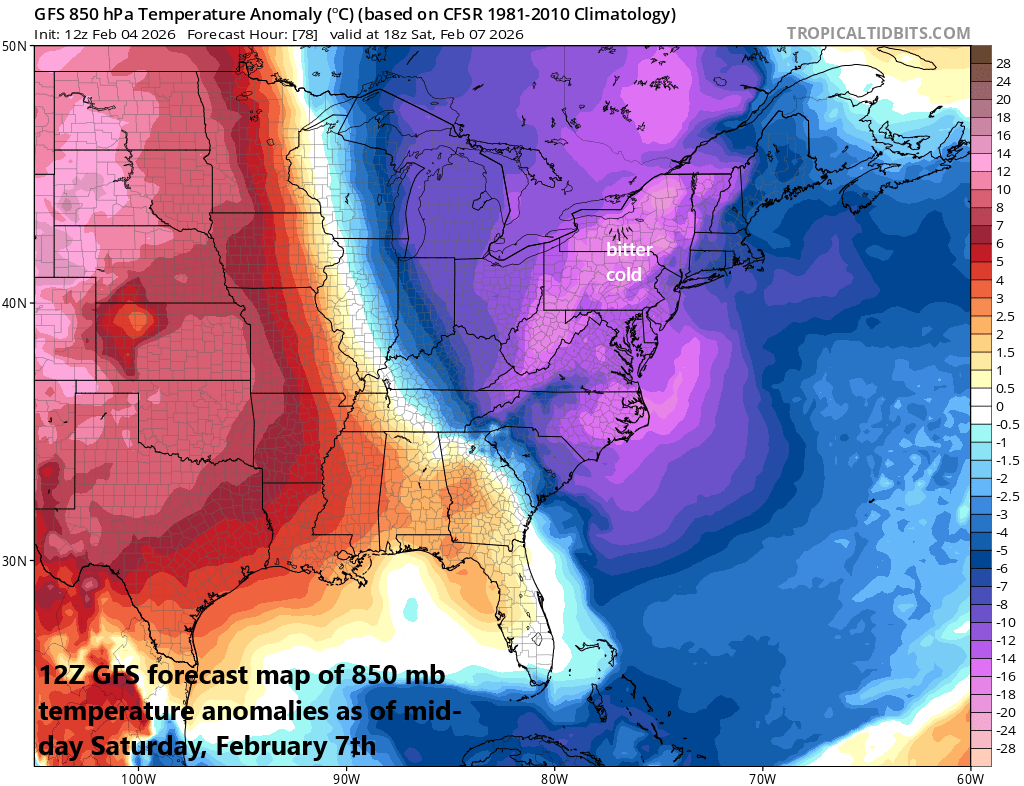
Bitter cold air will push into the Mid-Atlantic/NE US for the weekend and it will be accompanied by powerful winds gusts of 50+ mph. The combination of the bitter cold and powerful winds will result in dangerously low wind chill levels of well below zero in many spots on both weekend days. Map courtesy NOAA, tropicaltidbits.com
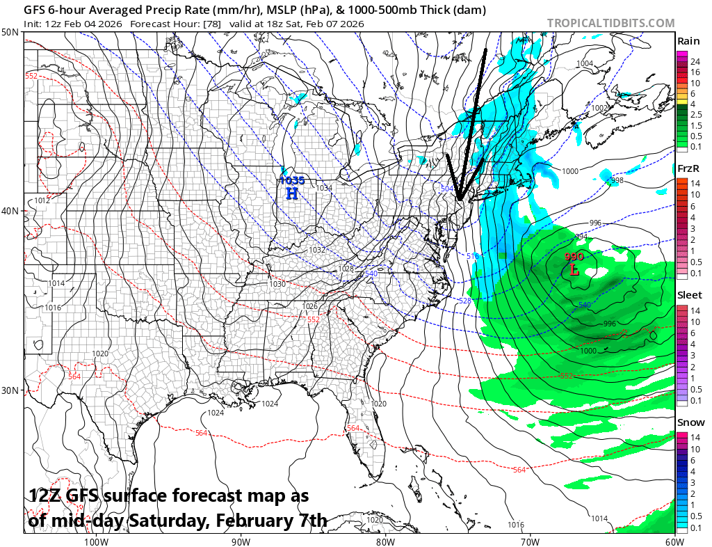
As a result, there can be some accumulating snow in the Mid-Atlantic/NE US on Friday afternoon that would be of the “overrunning” type associated with the warm front, and then additional snow or snow showers are likely on Friday night linked with the cold frontal passage, and perhaps even a few snow squalls will mix into the picture. Small accumulations of snow on the order of a coating to a couple of inches are possible on Friday afternoon and evening in the Mid-Atlantic/NE US, and there is an outside chance for a few inches somewhere in eastern New England. Any burst of heavier snow late Friday/Friday night can certainly create quickly deteriorating road conditions.
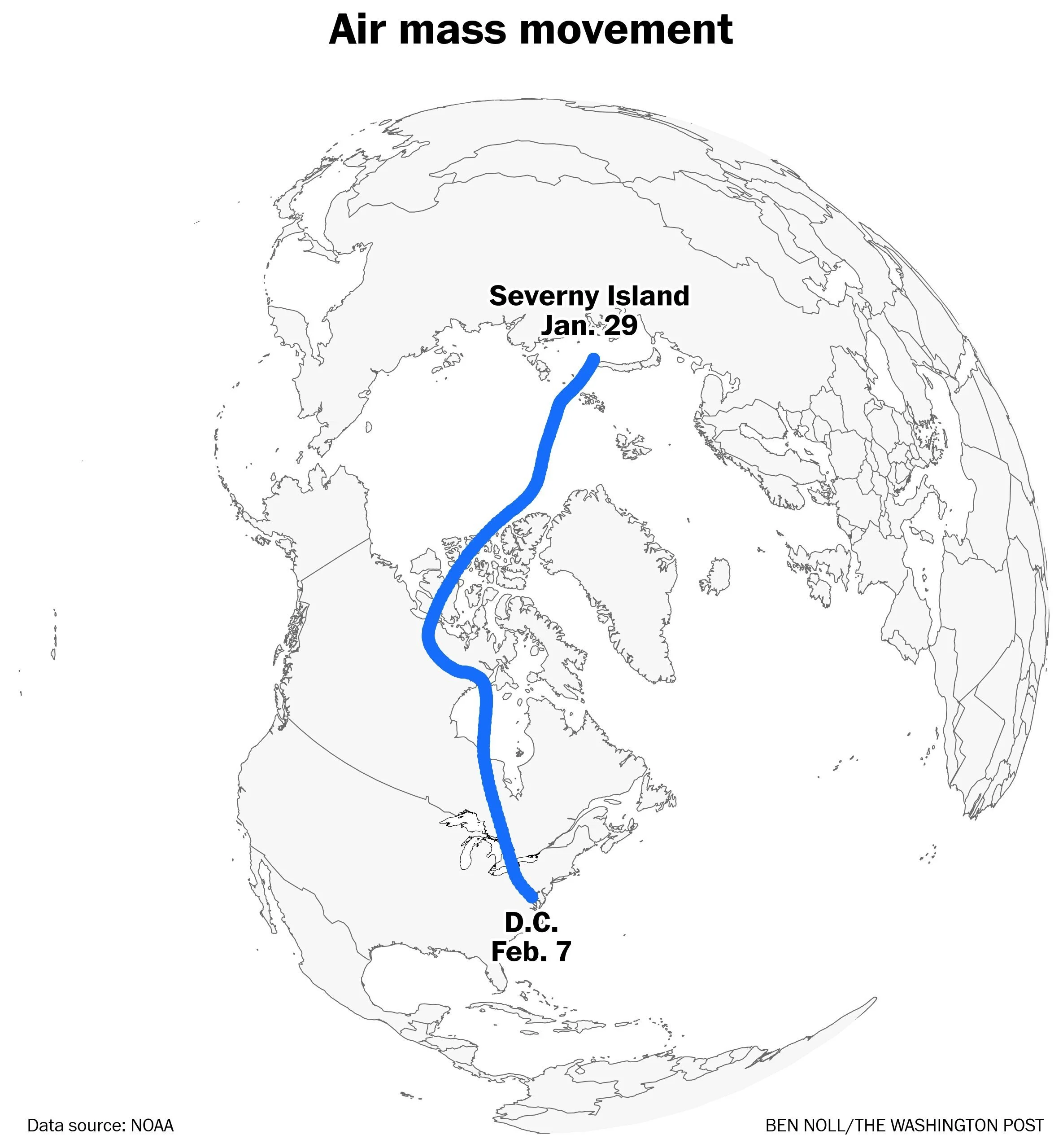
The Arctic air mass that pushes into the Mid-Atlantic/Northeast US this weekend will have its origins on the Siberian side of the North Pole. “Cross-polar” flow has transported this air mass in recent days to the North America side of the pole and it’ll move into the northeastern US this weekend in a “north-to-south” fashion. Map courtesy NOAA, Washington Post (Ben Noll)
On the heels of the cold frontal passage, there will be a direct discharge of Arctic air into the northeast US from the frozen tundra region of eastern Canada. This Arctic air mass is the real deal with its origins on the Siberian side of the North Pole...cross-polar flow of air has transported it to the North America side of the pole in recent days. The “north-to-south” trajectory of this incoming Arctic air mass from eastern Canada into the northeastern US is important and differs from the more typical “northwest-to-southeast” influx that crosses the Great Lakes.
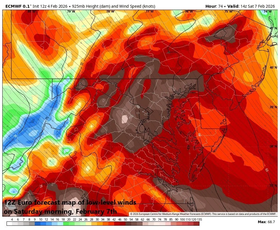
Powerful and potentially damaging winds are likely this weekend raising the possibility of power outages which would come at the worst possible time considering the bitter cold conditions that are expected. Map courtesy ECMWF, Weather Bell
When Arctic air crosses over the Great Lakes into the Mid-Atlantic/NE US, it tends to be modified through a couple different processes. First, Arctic air is modified by the time it reaches the I-95 corridor as it descends from the Appalachian Mountains and undergoes adiabatic compression which warms the air (“downsloping”). Second, Arctic air is modified from underneath as it crosses over the relatively warm waters of the Great Lakes which can still be largely unfrozen at this time of year. In fact, latest observations show that about 50% of the Great Lakes are unfrozen despite being well above historical averages in terms of total ice cover for the early part of February. Specifically, Lake Erie – the shallowest of the five Great Lakes - is almost completely frozen with 95% ice cover and this is its most ice coverage to start the month of February since 2003. Lake Huron is well frozen over as well with an impressive 77% ice cover in the most recent observation; however, Lakes Ontario, Superior and Michigan are currently at 37%, 34% and 33% respectively for their ice-cover levels.
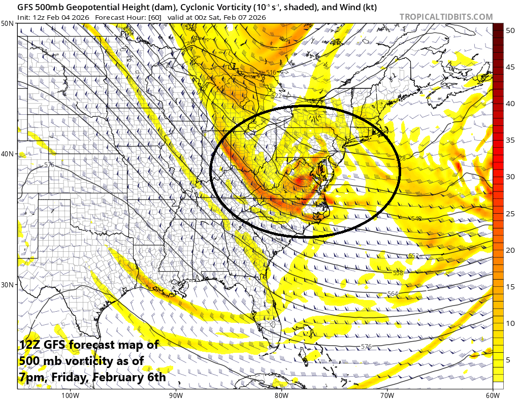
The Arctic frontal passage late Friday/Friday night will be supported aloft with an impressive area of “vorticity” (circled region) which will enhance upward motion in the Mid-Atlantic/NE US resulting in some snow and perhaps a few snow squalls. Map courtesy NOAA, tropicaltidbits.com
In the weekend scenario, the incoming Arctic air mass will not have those abilities for modification as it’ll push here from the snow-covered region of eastern Canada...directly to our north. In fact, some of the coldest air masses that have ever impacted places like Boston (MA) and New York City (NY) have arrived in this “direct discharge” fashion, and both urban areas will likely flirt with the zero degree mark this weekend. Elsewhere, single digit overnight lows will be widespread across the northeastern states in this weekend’s Arctic air invasion.
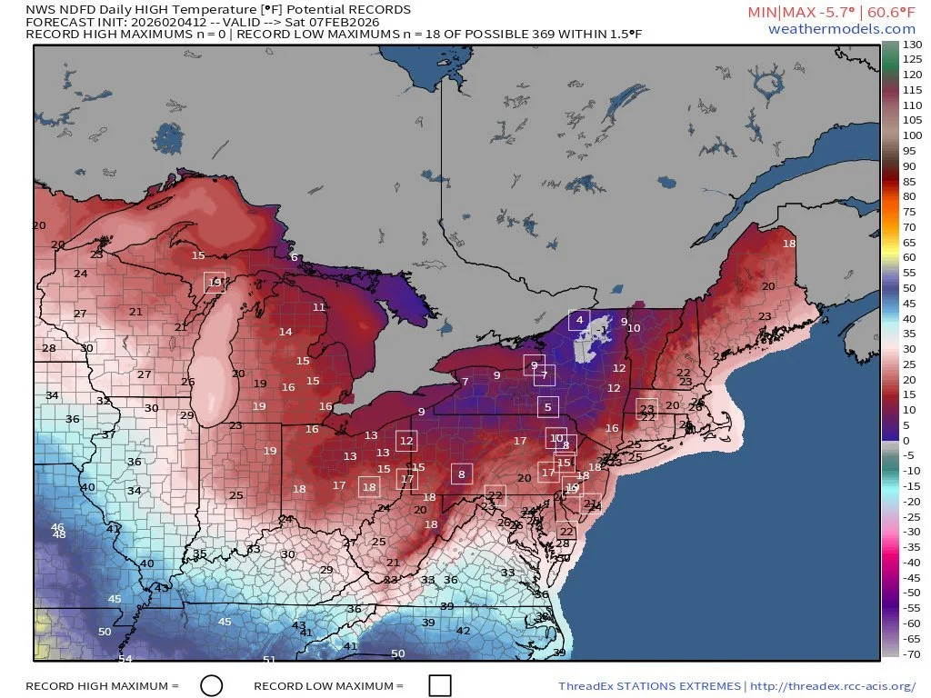
Many spots in the Mid-Atlantic/NE US will not be able to climb out of the teens or even single digits on Saturday for afternoon high temperatures and the result might be several record low high temperatures (as predicted here in the boxed-in locations). Map courtesy NOAA, weathermodels.com, BAM Weather
In addition to the bitter cold, the wind will become a major factor this weekend with gusts of 50+ mph on the table. The surface weather pattern will feature an intense departing low pressure system and a strong incoming high pressure and the pressure gradient between the two will become tight enough to result in powerful and potentially damaging winds on both weekend days. The combination of strong winds and bitter cold temperatures will likely result in dangerously low wind chill factors of well below zero in many spots on both Saturday and Sunday. By Sunday night, another clipper system is likely to drop southeast across the Great Lakes and into the Mid-Atlantic region and it might be able to some snow shower activity in parts of the area as we close out the Super Bowl weekend. The first part of next week will certainly feature below-normal temperatures; however, milder conditions are likely by the middle of next week…at least for a short time.
Meteorologist Paul Dorian
Arcfield
arcfieldweather.com
Follow us on Facebook, Twitter, YouTube
Video discussion: