
****An Arctic air invasion for the Mid-Atlantic/Northeast US...snow showers late Friday/Friday night...intense cold with powerful and potentially damaging winds...wind chills well below zero****
Paul Dorian
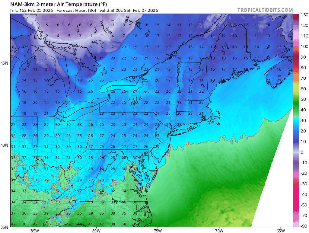
Arctic air will plunge into the Mid-Atlantic/NE US on Friday night and Saturday from the frozen tundra region of eastern Canada. Forecast loop of 2-meter temperatures courtesy NOAA (NAM), tropicaltidbits.com
Overview
An Arctic air mass will plunge into the Mid-Atlantic and Northeast US this weekend moving almost directly southward from the frozen tundra region of eastern Canada. Actually, this incoming Arctic air mass had its origins several days ago on the other side of the North Pole and was transported into North America from Siberia in a “cross-polar” overall wind pattern. The cold front at the leading edge of this bitter cold air mass will be quite active with strong support in the upper part of the atmosphere. As a result, numerous snow showers are likely on Friday night, and there can be bursts of heavier snow mixing into the picture...small accumulations and slick spots on the roadways are on the table. In addition to the bitter cold this weekend, biting and potentially damaging winds will become a major factor with gusts to 50+ mph raising the prospects for power outages in some areas. The combination of bitter cold air and powerful winds will result in dangerously low wind chill levels from later Saturday to early Sunday with apparent temperatures well below zero at times in many areas.
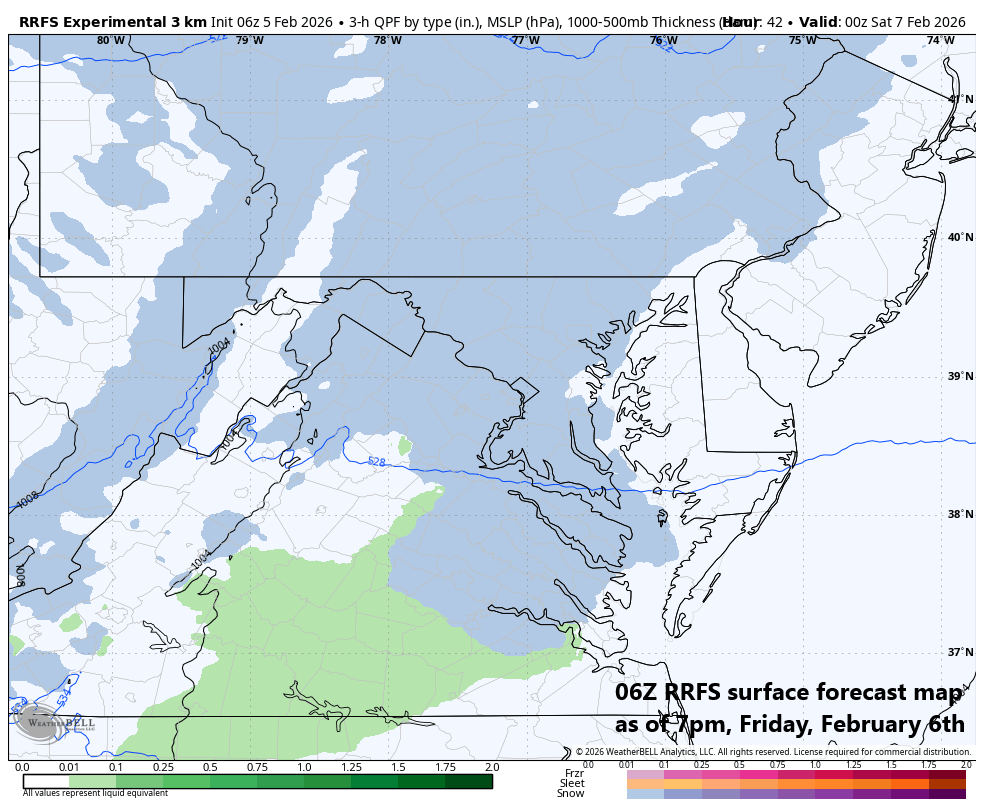
The approaching Arctic cold front on Friday night can generate numerous snow showers in the Mid-Atlantic region and a few heavier snow squalls are possible as well. Small accumulations of a coating to an inch or so are possible in the DC-to-Philly-to-NYC corridor…watch for slick spots. Farther to the north and east, a period of steadier snow is possible in the region from around Long Island to eastern Massachusetts where 3 or 4 inches can accumulate from later tomorrow night into early Saturday. Map courtesy NOAA, Weather Bell
Details
A clipper low pressure system will track across southern Canada on Friday passing well to the north of the Mid-Atlantic/NE US. Its associated warm front will lift across the area during the day on Friday and then its trailing Arctic cold front comes through from Friday night into early Saturday paving the way for a brutally cold weekend. This cold front will be strong and quite active with lots of support in the upper part of the atmosphere from an impressive shortwave of energy that will enhance upward motion across the northeastern states by later Friday and Friday night.
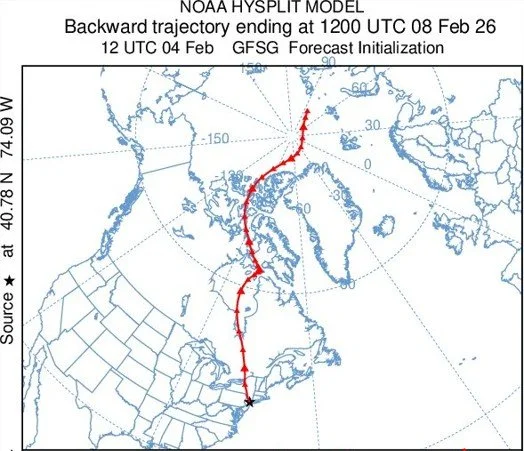
The weekend Arctic blast for the Mid-Atlantic/NE US originated on the Siberian side of the North Pole and rode into North America on a “cross-polar” overall wind flow. Map courtesy NOAA (12z GFS 7-day back trajectory at 100 meter level).
As a result, there can be numerous snow showers in the Mid-Atlantic/NE US later Friday and Friday night linked with the approaching cold frontal system, and perhaps even a few heavier snow squalls will mix into the picture. Small accumulations of snow on the order of a coating to an inch or so are possible in the DC-to-Philly-to-NYC corridor and slippery spots can form on the roadways; especially, during any heavier bursts of snow. Farther to the north and east in the region from Long Island to eastern Massachusetts, a period of steady snow is likely from later tomorrow night to early Saturday, and accumulations there can reach 3 or 4 inches.
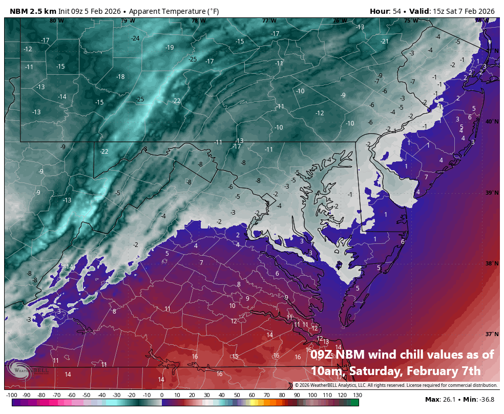
Wind chill values are likely to drop to well below zero this weekend due to the combination of the bitter cold conditions and powerful winds that can gust to 50+ mph. These apparent temperature levels can be dangerous for anyone stuck outdoors for any lengthy period of time. Map courtesy NOAA, Weather Bell
In addition to the bitter cold, the wind will become a major factor this weekend with gusts of 50+ mph on the table. The surface weather pattern will feature an intense departing low pressure system and a strong incoming high pressure and the pressure gradient between the two will become tight enough to result in powerful and potentially damaging winds on both weekend days and this raises the prospects of power outages in some areas.
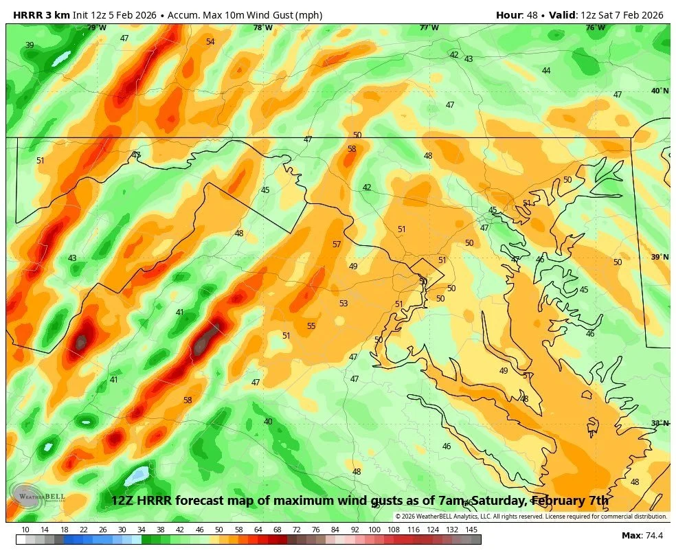
Powerful winds this weekend can gust past 50 mph raising the possibility of power outages in some parts of the Mid-Atlantic region and Northeast US. Map courtesy NOAA, Weather Bell
The combination of strong winds and bitter cold temperatures will result in dangerously low wind chill factors well below zero in many spots; especially, in the period from Saturday afternoon to Sunday morning. The first part of next week will certainly feature below-normal temperatures; however, milder conditions are likely by the middle of next week…at least for a short time.
Meteorologist Paul Dorian
Arcfield
arcfieldweather.com
Follow us on Facebook, Twitter, YouTube
Video discussion: