
*****Great Lakes blizzard on the way Sunday night and Monday...heavy rain, strong winds, severe thunderstorms on Monday in Mid-Atlantic/Northeast US****
Paul Dorian
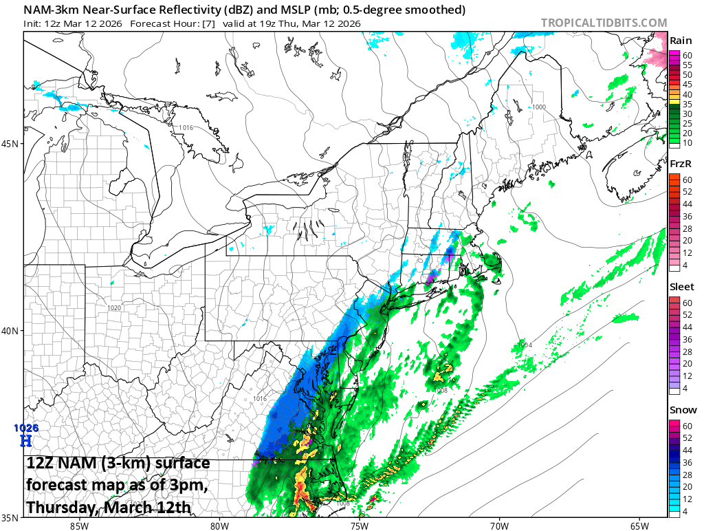
After record-warmth on Tuesday and Wednesday, many parts of the Mid-Atlantic region can experience some heavy, wet snow this afternoon as much colder air pours into the area on the backside of an intense cold front. Map courtesy NOAA, tropicaltidbits.com
Overview
An intense cold front barreled through the Mid-Atlantic region earlier today and temperatures have dropped sharply from early day highs in the 60’s and should reach the middle 30’s by early-to-mid afternoon. Rain is abundant on the back side of the front and - as colder air becomes better established - a changeover to snow is going to take place in many of the same areas of the Mid-Atlantic region that experienced 80-degree high temperatures during the past couple of days. Any snow that falls this afternoon will be of the heavy, wet variety and can certainly cling easily to grassy surfaces.
Over the weekend, another strong cold front will enter the weather picture as it moves to the nation’s midsection with a widespread colder-than-normal air mass on its backside and charging to the south and east. A strong storm system is likely to form along the frontal boundary zone as upper-level support arrives, and the Great Lakes may end up with an all-out blizzard come Sunday night and Monday with plenty of snow and powerful winds. In fact, there can be accumulating snow and strong winds in this same Great Lakes region on Friday from a clipper-system and this would precede the potential blizzard. The intense cold front will bring heavy rain and strong winds to the Mid-Atlantic region/Northeast US on Monday and there can be strong-to-severe thunderstorm activity…much colder air will follow for Tuesday and Wednesday.
What a difference a front makes!!…accumulating snow in parts of the Mid-Atlantic
Rain is still falling along much of the immediate DC-to-Philly-to-NYC corridor at midday, but the change to snow is not too far away. At 11am, the changeover to snow has already taken place from Culpeper Virginia to Hagerstown, MD and this rain/snow line will push eastward during the next few hours with snow likely to develop in the DC metro region and then farther north into southeastern PA. Even the NYC metro area can see some flakes later in the day…just a couple of days after peaking at the 80-degree mark in Central Park…their earliest time for that in recording history. Any snow that falls this afternoon will be of the heavy, wet variety and it should be able to cling easily to grassy surfaces. If the snow comes down quite hard - which is indeed a real possibility – then it might be able to stick on untreated road surfaces as well. Accumulations of a coating to as much as a couple of inches are possible this afternoon in and around the DC metro area, a coating to an inch in the Philly metro region, and perhaps a coating in NYC.
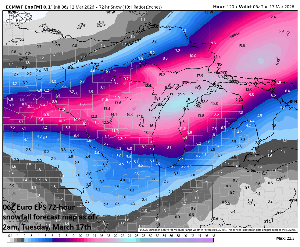
The Great Lakes region will be pounded by a blizzard on Sunday night and Monday and a Friday clipper-system can bring accumulating snow to the same part of the country. The combination of the two storms can result in as much as a foot and a half of snow by the time Monday evening rolls around. Map courtesy ECMWF, Weather Bell
Great Lakes late weekend blizzard (and a preceding Friday snowstorm)
Another strong cold front will enter the picture this weekend reaching the middle of the by Sunday and it will feature a sharp temperature gradient at surface level and there will be lots of support aloft with a deepening upper-level trough of low pressure moving overhead. Surface low pressure will deepen dramatically by late Sunday over the Great Lakes, likely leading to an all-out blizzard going into Monday with substantial snowfall and powerful winds potentially reaching 60+ mph.
Much of this same Great Lake’s region may actually experience accumulating snow and strong winds on Friday – two days before the expected late weekend/early week blizzard – as a clipper system moves through the area. The combination of these two storms may end up resulting in well over a foot of snow across portions of the Great Lakes by the time we get to the early part of next week.
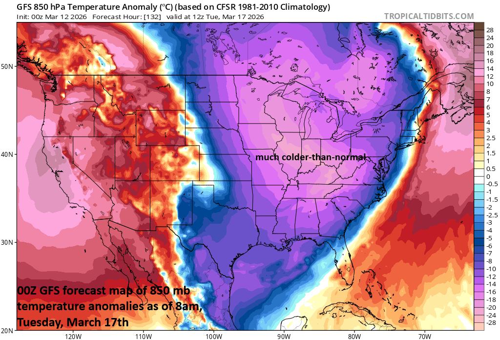
A much colder-than-normal air mass will reach the Mid-Atlantic region by Monday night and temperatures are likely to be confined to the 20’s and 30’s on Tuesday for afternoon highs. Map courtesy NOAA, tropicaltidbits.com
Heavy rain, strong winds on Monday in Mid-Atlantic/NE US with next intense cold front…possible severe thunderstorms as well…much colder air follows for Tuesday and Wednesday
This next intense cold front associated with the powerful Great Lakes storm system will close in on the eastern states on Monday and there will be very strong winds ahead of it along with heavy rain and the possibility for strong-to-severe thunderstorms. The cold front should clear through the area late Monday night ushering in a well below-normal air mass for Tuesday and high temperatures are likely to be in the 20’s and 30’s in much the same areas that experienced 80+ degrees earlier this week.
Talk about March Madness!
Meteorologist Paul Dorian
Arcfield
arcfieldweather.com
Follow us on Facebook, Twitter, YouTube
Video discussion: