****High risk of severe weather in parts of the Mid-Atlantic region… downpours, localized flooding, damaging winds, isolated tornadoes, power outages...all on the table****
Paul Dorian

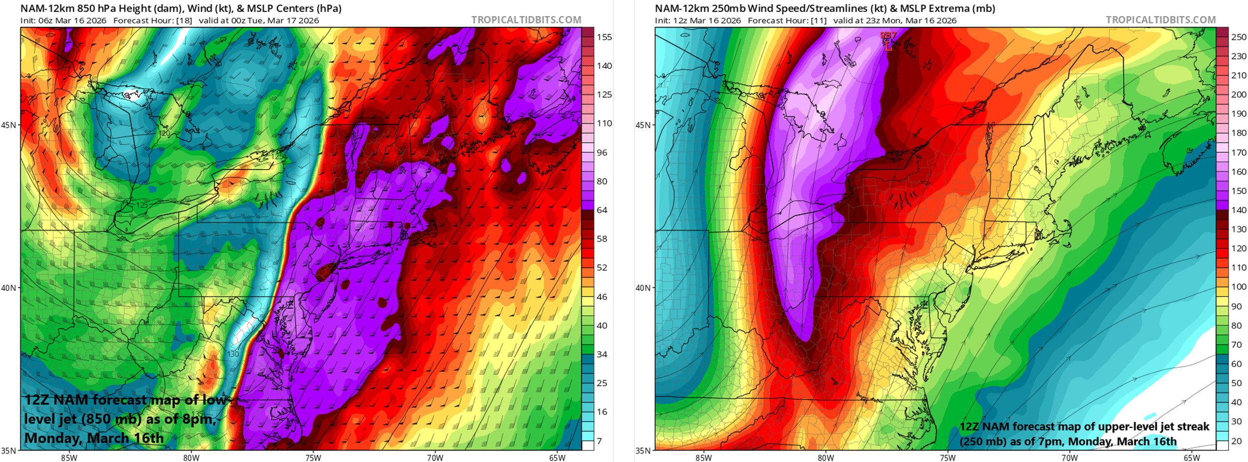
Multiple jet streaks will play critical roles later today in the severe weather and tornado threat across the Mid-Atlantic region. A low-level jet (left map) will increase low-level wind shear (and the chance for isolated tornadoes) and an upper-level jet (right map) will increase upward motion in the area…both leading to rapid destabilization of the atmosphere. Map courtesy NOAA, tropicaltidbits.com
Overview
There is an unusually high risk of severe weather in parts of the Mid-Atlantic region from today into the late evening hours with numerous ingredients coming together. The severe weather risk will include all the following weather parameters: downpours, localized flooding, damaging winds, lightning, hail, isolated tornadoes and power outages are all on the table. Multiple rounds of showers and thunderstorms are likely into the late evening hours and severe weather can develop with any of these bands from mid-day on through the late evening. Much colder air pours into the Mid-Atlantic region in the overnight hours and temperatures will be well below normal on Tuesday and lows tomorrow night can bottom out near the 20-degree mark in some suburban locations. The Great Lakes “snow machine” will be turned on as well on Tuesday with numerous snow bands likely just downstream and a few snow showers can make it into the I-95 corridor.
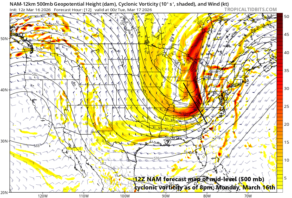
An upper-level trough will become “negatively-tilted” as the day progresses leading to enhanced upward motion in the Mid-Atlantic region…one of many ingredients coming together for this severe weather outbreak. Map courtesy NOAA, tropicaltidbits.com
Details
Multiple rounds of showers and thunderstorms will impact the Mid-Atlantic region today and severe weather can take place with any of these bands from mid-day on through the late evening hours. Of the big cities along the DC-to-Baltimore-to-Philly-to-NYC corridor, the greatest chance of severe weather is likely to be in Washington, D.C. and Baltimore, MD, and the lowest threat in New York City where the atmosphere will be a bit more stable compared to areas to their southwest.

Strong storms are pushing towards the western suburbs of Washington, D.C. as of late morning and severe weather is a possibility in the mid-day/early afternoon hours. Map courtesy NOAA
In fact, one batch of thunderstorms is approaching the western suburbs of DC as of late morning and could cause severe weather there during the mid-day and early afternoon hours…tornadoes are indeed a possibility. Other bands will form during the mid-afternoon hours and continue into the late evening and this activity could include an organized north-to-south oriented squall line. This organized squall line could produce damaging “straight-line” winds as it barrels from west-to-east across the area later today...and a few tornadoes are possible as well between the mid-afternoon and late evening hours.
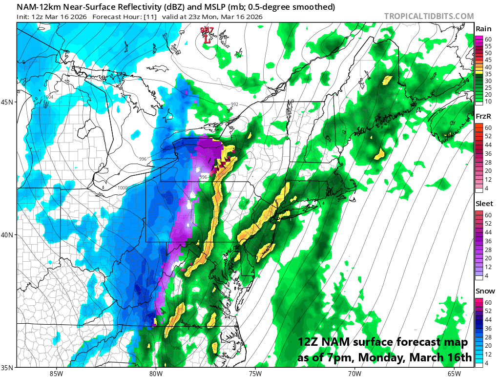
An organized squall line may form later today just ahead of the incoming strong surface cold front with powerful and damaging “straight-line” winds a possibility in the I-95 corridor and there can be isolated tornadoes as well. Map courtesy NOAA, tropicaltidbits.com
Numerous ingredients are coming together to enhance this severe weather threat in the Mid-Atlantic region including the passage of a warm frontal system this morning that ushered in warmer and humid air, and an incoming strong cold front that arrives later tonight with much colder than normal air on its backside. In addition, multiple jet streaks are to play a key role in the overall atmospheric instability with an upper-level jet acting to enhance upward motion in the area and a strong low-level jet which increases wind shear (and a tornado threat) just ahead of the frontal passage. Also, a strong upper-level trough will take on a “negative-tilt” as the day progresses also adding to the upward motion across the Mid-Atlantic region. Another note, winds today can be very strong even outside of any thunderstorm activity with southerly winds potentially up to 50 mph in localized areas ahead of the incoming surface cold front.
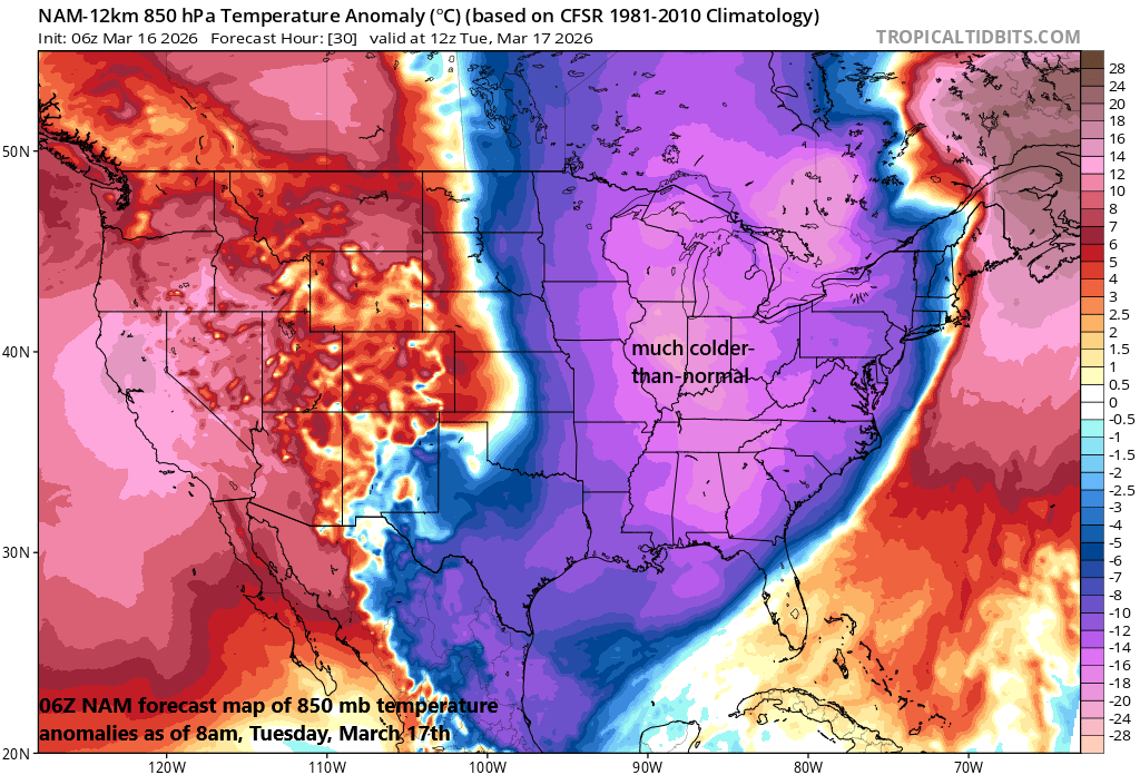
Much colder-than-normal air pushes into the Mid-Atlantic region late tonight and Tuesday and temperatures tomorrow night can plunge to near the 20-degree mark in some suburban locations. Map courtesy NOAA, tropicaltidbits.com
In the overnight hours, much colder air will flood the region, and the strong pre-frontal southerly winds will shift to a west-to-northwest direction and remain quite strong. As with the passage of last week’s intense cold front, some areas will see a changeover to snow for a brief time as the cold air arrives; especially, across some of interior higher elevation locations well to the northwest of I-95.
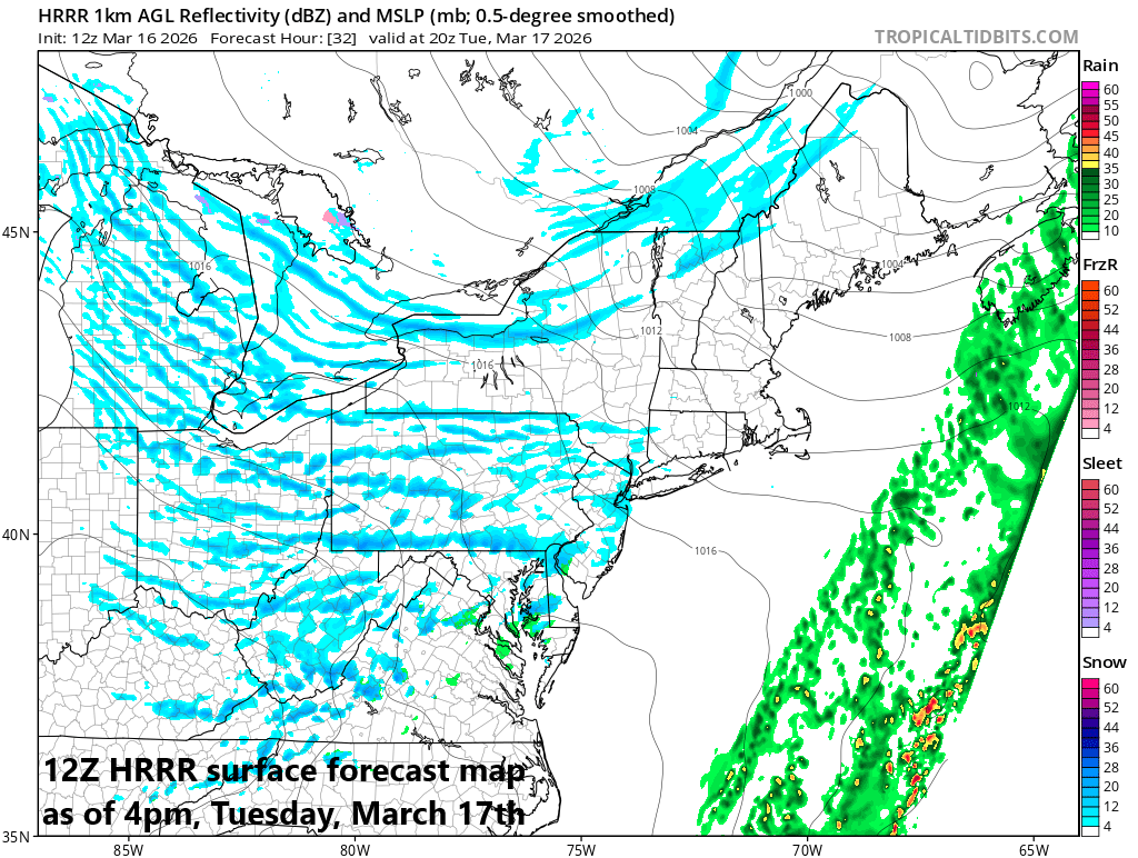
The Great Lakes “snow machine” gets turned on tomorrow and it’ll lead to numerous snow bands just downstream of the lakes…some snow shower activity can make it all the way into the I-95 corridor. Map courtesy NOAA, tropicaltidbits.com
During the day Tuesday, the Great Lakes “snow machine” will get turned on and lake-effect snow bands are likely to impact many areas just downstream of the lakes and a few snow showers can make their way into the I-95 corridor. The below-normal chill will stick around through the middle of next week and then milder weather returns by week’s end, but there may be some suffering to get through before we get to that point…stay safe…basement or lowest level if at home.
Meteorologist Paul Dorian
Arcfield
arcfieldweather.com
Follow us on Facebook, Twitter, YouTube
Video discussion: