Monday AM - ***Snow this afternoon in DC metro with small accumulations, freezing rain tonight...precipitation reaches Philly metro by daybreak on Tuesday in the form of freezing rain***
Paul Dorian

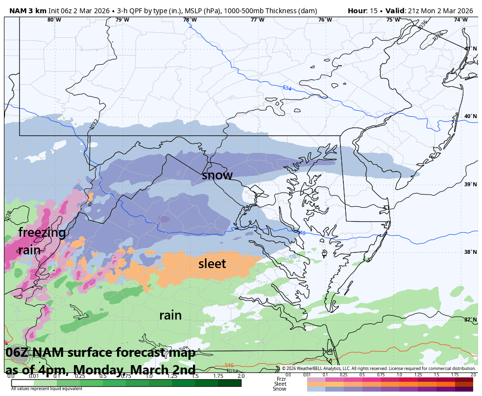
The 12z HRRR surface forecast map as of 4pm, Monday with snow across northern Maryland, much of Virginia and in the DC metro area. Map courtesy ECMWF, Weather Bell
Overview
After a very mild day on Saturday, a strong cold front passed through the Mid-Atlantic region on Sunday and ushered in a much colder-than-normal air mass for the early part of the new work week. The cold front has dropped just to the south of the area and low pressure will ride along the boundary zone today and snow is likely in the DC metro region this afternoon with some accumulations. By tonight, the dominant precipitation type in the DC metro region will be freezing rain and this could last into the early morning hours on Tuesday. Farther north, precipitation is likely to hold off in the Philly metro region until around daybreak on Tuesday and freezing rain will likely be the dominate precipitation through the morning hours. Watch for slick spots in both metro regions before a changeover to plain rain and above-freezing temperatures.
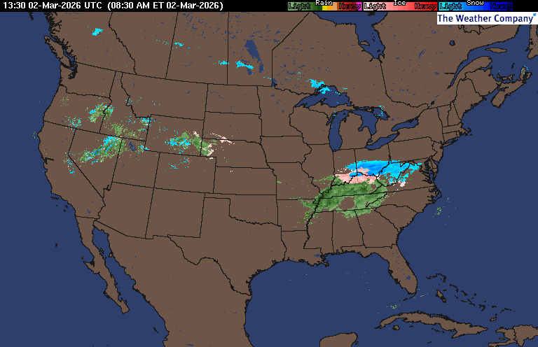
Latest radar images feature snow (in blue) just to the west of the DC metro region and this moisture field is moving from west-to-east. Radar courtesy WSI, Weather Underground, NOAA
Details
What a difference a cold front makes...after a spring tease on Saturday, a strong cold front passed through the Mid-Atlantic region on Sunday setting the stage for a cold start to the new work week and some frozen precipitation. Low pressure will push along the frontal boundary zone from later today into Tuesday and snow is likely to break out in the DC metro region around midday and continue into the evening hours. Accumulations are likely on the order of an inch or two; especially, on grassy surfaces where it will stick more quickly. The snow will then mix with and ultimately change over to freezing rain this evening in the DC metro region and continue into the early morning hours on Tuesday. Later tomorrow, plain rain is likely as temperatures climb towards an afternoon high near the 45-degree mark...watch out for slick spots during the “frozen precipitation” time period from this afternoon into early Tuesday.
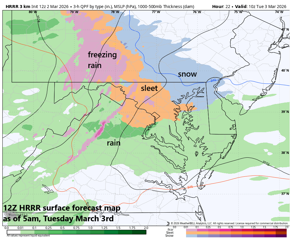
The 12z HRRR surface forecast map as of 5am, Tuesday with snow on the doorstep in the Philly metro region. Map courtesy ECMWF, Weather Bell
This initial batch of moisture associated with the low-pressure system will not push north of the PA/MD border until around daybreak on Tuesday. Clouds will thicken up across the Philly metro region this evening and precipitation could break out there around 5 or 6 am on Tuesday just in time for the AM commute and most likely in the form of freezing rain, but sleet and/or snow can be mixed in at times. There can be small accumulations of ice and/or snow in the morning before the precipitation changes to plain rain for the afternoon…watch out for possible AM slick spots in the Philly metro region.
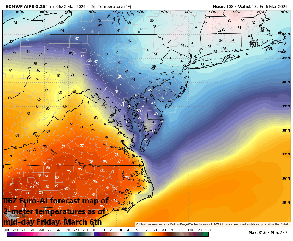
This time of year is famous for backdoor cold fronts in the northeastern part of the country which can quickly flip a spring-like day to winter’s chill. This kind of a flip is possible on Friday in the Mid-Atlantic region; especially, in the region from Philly and NYC to the north and east where colder low-level air could move in from the northeast. Map courtesy ECMWF, Weather Bell
At mid-week, much milder air will reach the northeastern part of the country, but it will be plagued with multiple rounds of showers. As is often the case this time of year, the warmup in the northeastern states can be interrupted by the dreaded backdoor cold front which can flip a much warmer-than-normal day into a winter-like scenario in a hurry. The chance of this kind of turnaround exists for Friday of this week; especially, in Philly and NYC and places farther north and east. If indeed it becomes colder on Friday, this would only be a temporary setback, and it should turn much milder again this weekend and early next week.
One final note of interest, the December/January/February time period in Washington, D.C. turned out to be the coldest since the winter of 2002-2003.
Meteorologist Paul Dorian
Arcfield
arcfieldweather.com
Follow us on Facebook, Twitter, YouTube
Video discussion: