**Possible record-breaking warmth today, but big changes are coming...much cooler on Sunday/Monday and again late April/early May...widespread frost/freeze potential late Monday night**
Paul Dorian

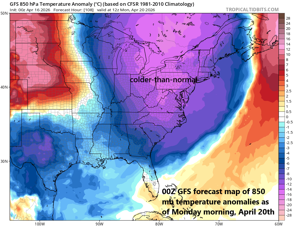
Much cooler air will push into the Mid-Atlantic region for Sunday and Monday and temperatures could drop way down in the 30’s by early Tuesday morning prompting frost and/or freeze advisories in most areas. Map courtesy NOAA, tropicaltidbits.com
Overview
The unseasonably warm conditions in the Mid-Atlantic region will continue for one more day and many spots today will challenge their daily high temperature record. It’ll remain on the warm side on Friday and Saturday, but not quite the record-challenging warmth experienced here during the past couple of days. The warmer weather pattern breaks down over the weekend as a strong surface cold front heads toward the eastern states at the same time intense high pressure ridging along the coast slides to the east.
The front will bring with it a good chance of much-needed shower activity late Saturday night and Sunday morning and it’ll usher in a much cooler air mass to close out the weekend and start the new work week. In fact, temperatures late Monday night/early Tuesday are likely to drop way down to freezing or below in much of the Mid-Atlantic region which could prompt widespread frost and freeze warnings. Temperatures rebound noticeably by mid-week, but an overall pattern change will bring additional colder-than-normal air masses to the central and eastern states during late April/early May.
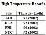
High temperature records are within reach today in the Mid-Atlantic’s I-95 corridor region. All of the listed record highs took place in another unusual early season heat wave in April of 2002.
90-degree highs on the table today...rare for April, but not unprecedented
While certainly rare, 90-degree heat in the Mid-Atlantic region during the month of April is not unprecedented. The most recent instance of this record-breaking type of early season warmth took place in April 2002 when Philly, as an example, reached 90+ degrees on 3 days between the 15th and 19th. In fact, the high temperature records for today along the I-95 corridor were set in 2002 with 91 degrees observed at Dulles Airport (IAD) in Virginia, 92 degrees at Reagan National Airport (DCA) in Washington, D.C., 90 degrees at Philly Intl Airport (PHL), and 92 degrees in New York’s Central Park...all within reach.
Prior to 2002, April of 1976 featured some extreme heat in the Mid-Atlantic region with an incredible 96 degrees recorded in New York’s Central Park on Easter Sunday (4/18). The 96-degree reading at NYC actually turned out to be the highest temperature measured for the entire year in the Big Apple. Also, in this early season heat wave of 1976, the city of Brotherly Love - where the Bicentennial was being celebrated - experienced 90+ degrees on 4 occasions at PHL between the 16th and 21st. Other notable heat waves that occurred in the Mid-Atlantic region during April were in the following years: 1962, 1960, 1954 and 1941 (credit Meteorologist Chris Martz).
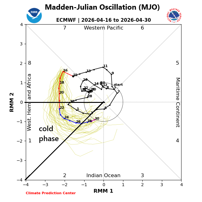
A tropical disturbance that is tracked by meteorologists using the Madden-Julian Oscillation will push into what is known as “phase 1” by late April. This location of the MJO is typically correlated with colder-than-normal conditions across the central and eastern US during this time of year. Plot courtesy NOAA, ECMWF
Warm weather pattern breaks down
While still quite warm for this time of year, the next couple of days will be less extreme than today and record highs are less likely to occur as changes get underway in the overall weather pattern. The record-breaking warmth of the past couple of days has been contributed to by an intense upper-level ridge of high pressure situated along the east coast, but this system will start to weaken in coming days and slide to the east. In addition, a strong surface cold front will push towards the east coast by late Saturday night, bringing with it a good chance of much-needed shower activity on Saturday night and Sunday.
The passage of the cold front will usher in a much cooler air mass for Sunday and Monday with highs closer to 60-degrees to close out the weekend as compared to the 90+ degrees possible later today. By Monday night, the atmosphere may be set up for excellent radiational cooling conditions in the Mid-Atlantic region with clear skies and light winds as high pressure edges overhead. As a result, temperatures could drop to freezing or below by late Monday night/early Tuesday potentially prompting widespread frost and/or freeze warnings to be issued. Temperatures may rebound quickly by mid-week; however, additional colder-than-normal air masses are likely to reach the northeastern states during late April and early May.
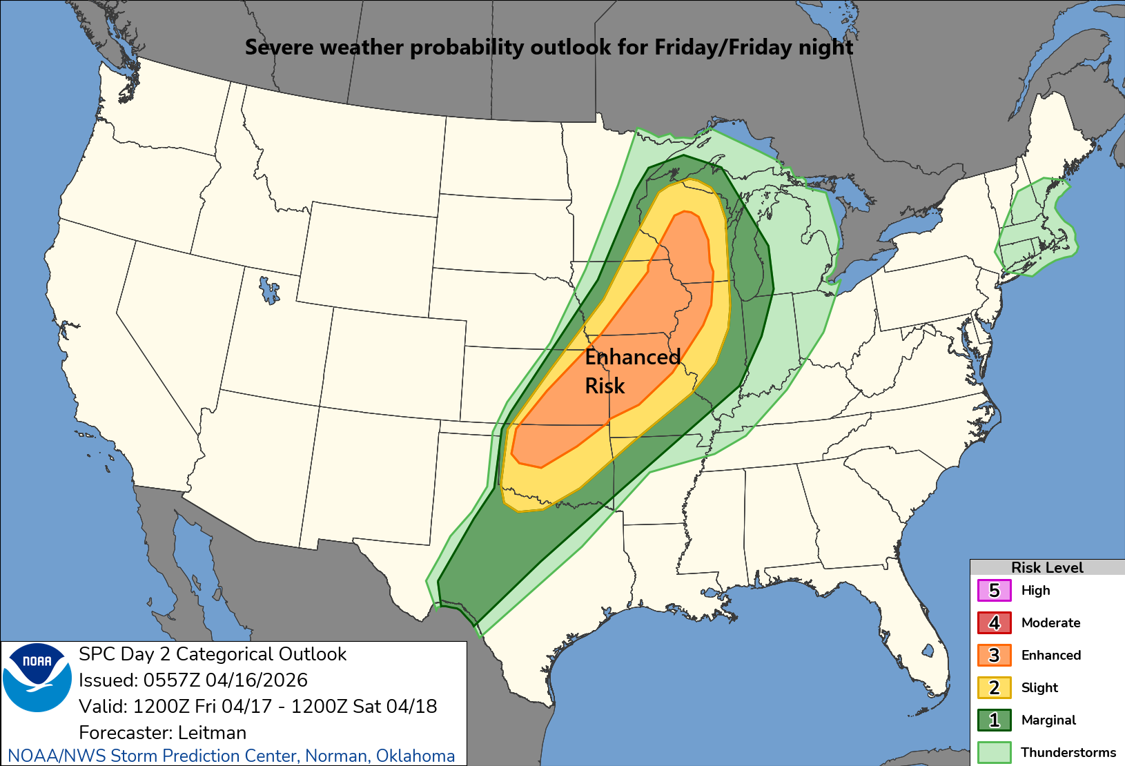
An enhanced risk of severe weather is on the table for later tomorrow and tomorrow night in the region from Texas to the Great Lakes. Map courtesy NOAA/SPC
Severe weather threat on Friday/Friday night Texas-to-Great Lakes
The strong cold front that is likely to reach the I-95 corridor region by late Saturday night will first push through the nation’s mid-section. The combination of warm, humid air flowing northward from the Gulf to the Mississippi Valley and cold, dry air dropping southeastward from Canada will create unstable conditions later tomorrow into tomorrow night. This is likely to lead to an enhanced risk of severe weather on Friday afternoon and night all the way from Texas to the western Great Lakes to include such cities as Kansas City, Missouri and Madison, Wisconsin. On Saturday, as the cold front shits to the east, the severe weather threat will re-develop across the northern Ohio Valley although likely not as widespread as it will be on Friday/Friday night across the nation’s mid-section.
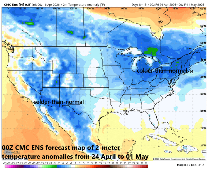
The overall weather pattern is likely to flip from today’s significant warmth across the central and eastern states to generally colder-than-normal conditions for the last week of April. Map courtesy Weather Bell Analytics, Canadian Met Centre
Looking ahead to late April/early May
A teleconnection index known as the Madden Julian Oscillation or MJO will be moving into what is normally a colder-than-normal “phase” this time of year for the central and eastern states. The MJO tracks a tropical disturbance that regularly treks from the Indian Ocean to the western Pacific Ocean. With movement of the MJO to the particular location known as “phase 1”, odds will be quite high for colder-than-normal air masses to move into the eastern half of the nation during the last week of April and early part of May. This “cold” outlook suggested by the MJO is supported by trends in other teleconnection indices such as the North Atlantic Oscillation (NAO) and Arctic Oscillation (AO).
Meteorologist Paul Dorian
Arcfield
arcfieldweather.com
Follow us on Facebook, Twitter, YouTube
Video discussion: