
****A flip on the calendar from June to July activates the atmospheric furnace in the northeastern states...100+ degrees on the table all along the DC-to-Boston corridor****
Paul Dorian
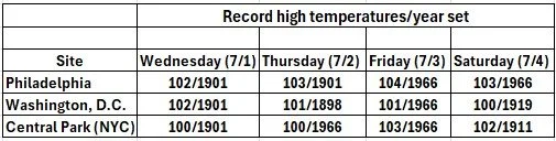
This coming heat wave can result in many record high temperatures including in the Mid-Atlantic’s I-95 corridor. The all-time temperature record happens to be the same 106 degrees in Philly, Washington, D.C., and Central Park (NYC).
Overview
The month of June has been relatively benign in terms of overall temperatures along the I-95 corridor, but the flip to July on Wednesday will set off the atmospheric furnace in the northeastern states. The time period from tomorrow through Saturday, the 4th of July, will feature afternoon high temperatures near or even slightly above the 100-degree mark in much of the DC-Boston corridor with record highs in jeopardy. Intense upper-level high pressure ridging will be the key player and catalyst for the excessive heat and humidity in the northeastern part of the nation. At the same time, the western states will enjoy colder-than-normal conditions with deep upper-level trough persisting in that part of the nation.
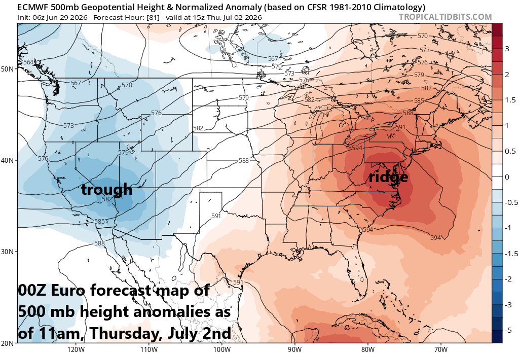
While the western US will deal with an upper-level trough in coming days, intense ridging will expand into the northeastern states and the result will be a major-league heat wave that can bring high temperatures to the 100-degree mark in many locations in the Wednesday through Saturday time period. Map courtesy ECMWF, tropicaltidbits.com
Details
So far this season, the I-95 corridor has largely escaped any sustained high heat and humidity, but the calendar flip from June to July will seemingly be the trigger for a major league heat wave in the northeastern states. June has been relatively benign in the I-95 corridor in terms of temperature anomalies (e.g., DCA +0.8 degrees, Central Park +1.3 degrees), but all of that changes as we begin the month of July with excessive heat on the way for Wednesday, Thursday, Friday and Saturday (4th of July). In fact, temperatures can reach or even slightly surpass the 100-degree mark during this 4-day stretch with records in jeopardy in many locations. The all-time temperature record in the Mid-Atlantic’s I-95 corridor happens to be the same 106 degrees in Washington, D.C. (July 20, 1930, August 6th, 1918), Philadelphia (August 7th, 1918), and Central Park in NYC (July 9th, 1936).
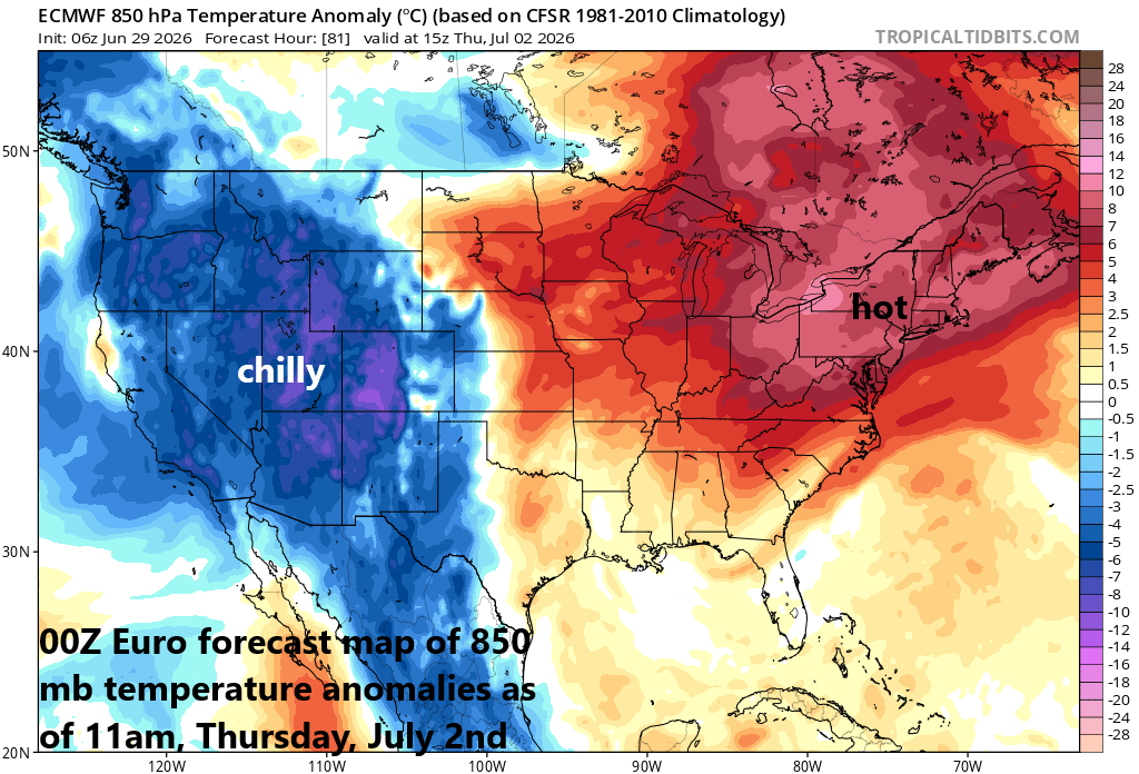
While the eastern states bake, the western part of the nation will feature below-normal temperatures as an upper-level trough hangs around that part of the nation for several days. Map courtesy ECMWF, tropicaltidbits.com
The main culprit in the outlook for excessive heat and humidity will be anomalously intense upper-level ridging which will end up centered over the Mid-Atlantic region. Interestingly, at the same time there will be a deep upper-level trough of low pressure centered over the western US leading to colder-than-normal conditions in that part of the nation and even some snow across portions of Idaho, Montana, and Wyoming. The upper-level ridge across the eastern US may begin to break down by the end of the week or early part of the upcoming weekend; especially, across the Northeast US as upper-level waves of energy rotate around the northern periphery of the high-pressure system. As a result, the chance for showers and thunderstorms will begin to rise on Friday and may increase some on the 4th of July (Saturday); especially, across the Northeast US. In many past heat waves of this nature, the end comes with a big bang so we’ll have to monitor the prospects for strong-to-severe thunderstorms by the weekend in some portions of the northeastern states.
Meteorologist Paul Dorian
Arcfield
arcfieldweather.com
Follow us on Facebook, Twitter, YouTube
Video discussion: