***Unfolding pattern can result in a severe weather/heavy rain threat for the Mid-Atlantic region this weekend...hot weather to precede with a spike to near 100 degrees...areas of smoke***
Paul Dorian
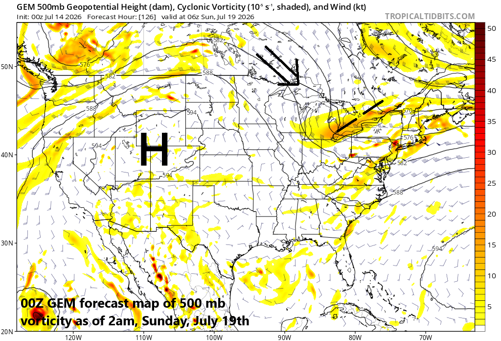
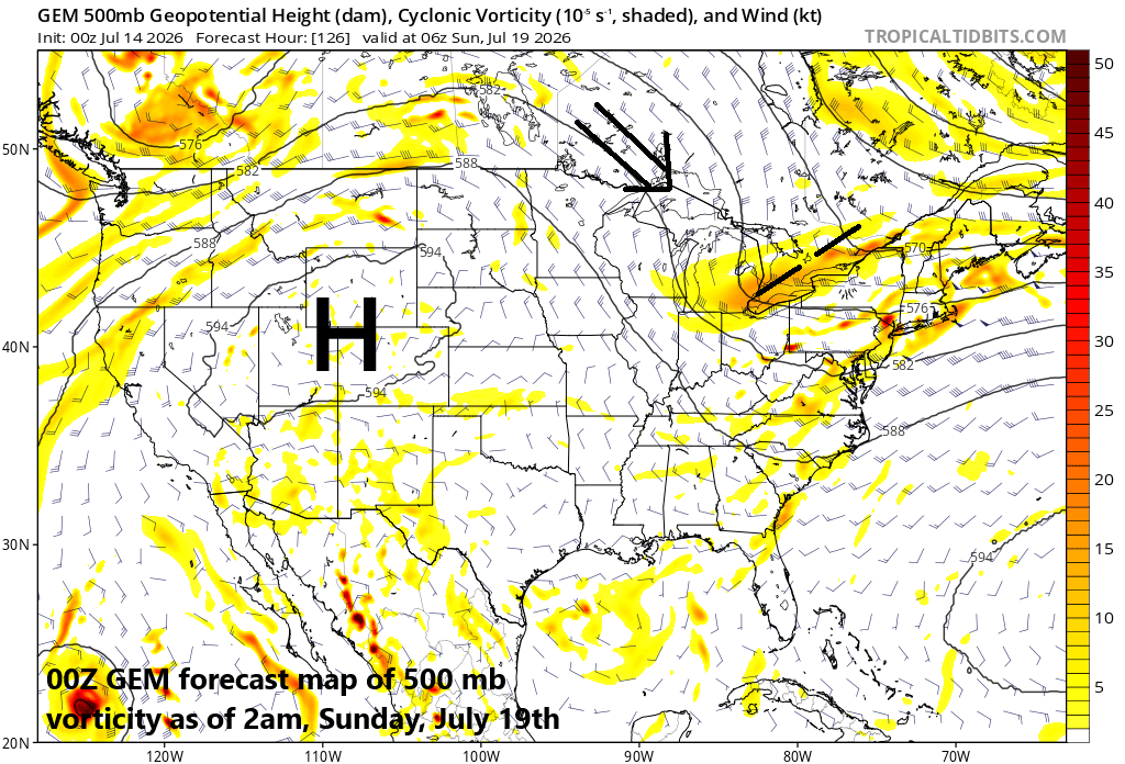
The outer perimeter of an intense ridge of high pressure can sometimes be an area in the summer season that feature lines or complexes of thunderstorms. In this case, the northeastern quadrant of the ridge will be an area to watch this weekend for the potential of severe weather and heavy rain. Map courtesy Canadian Met Centre, tropicatidbits.com
Overview
The overall weather pattern may be setting up for a severe weather and heavy rain threat in the Mid-Atlantic region during the first half of the upcoming weekend. The pattern will feature an intense ridge of high pressure centered over the Rocky Mountain States by the weekend with northwesterly flow over the Great Lakes/Northeast US. Often times, this kind of flow results in “lines” or “complexes” of thunderstorms dropping to the south and east from the Great Lakes to the northeastern states and that is on the table for Saturday. The potential exists for heavy rain/flash flooding as well as precipitable water in the atmosphere will climb to high levels. The weekend threat will be preceded by hot weather that can see temperatures surge to near the century mark on Wednesday anywhere along the DC-to-Philly-to-NYC corridor. One final note, wildfire smoke from Canada will likely drop south and east into the Mid-Atlantic region during the next couple of days and it certainly can dim the skies at times.
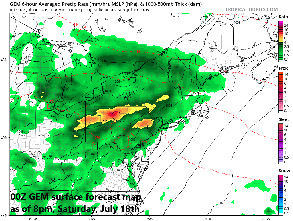
Still several days away, but there is the chance for severe weather and heavy rain this weekend in the Mid-Atlantic region as northwesterly flow on the periphery of an intense ridge combines with an impressive short-wave dropping southeast from the Great Lakes. Map courtesy NOAA, Canadian Met Centre
Details
The outer perimeter of an intense high-pressure ridge can be an area where severe weather develops during the summer season. Specifically, the far northeastern quadrant of an intense high-pressure ridge can feature “lines” or “complexes” of thunderstorms that drop to the south and east riding along in broad northwesterly flow of air. In fact, this is the type of upper air pattern that can produce derechos...long-lasting “lines” of thunderstorms that travel across a large area. By Saturday, intense ridging of high pressure will be centered over the Rocky Mountain States and northwest flow will be found aloft in the far northeastern quadrant of the ridge. In addition, a surface frontal system will sink into the area, and it could stick around into Sunday.
Another key player this weekend will be a wave of energy in the upper atmosphere that can enhance upward motion and shear all the way from the Great Lakes to the Mid-Atlantic...potentially resulting in strong-to-severe thunderstorms that can travel in a southeastward fashion. The moisture levels in the atmosphere will be quite high by the weekend in the Mid-Atlantic region (2+ inches precipitable water values), and should thunderstorms develop, they can generate some heavy rainfall, and flash flooding could be a concern.
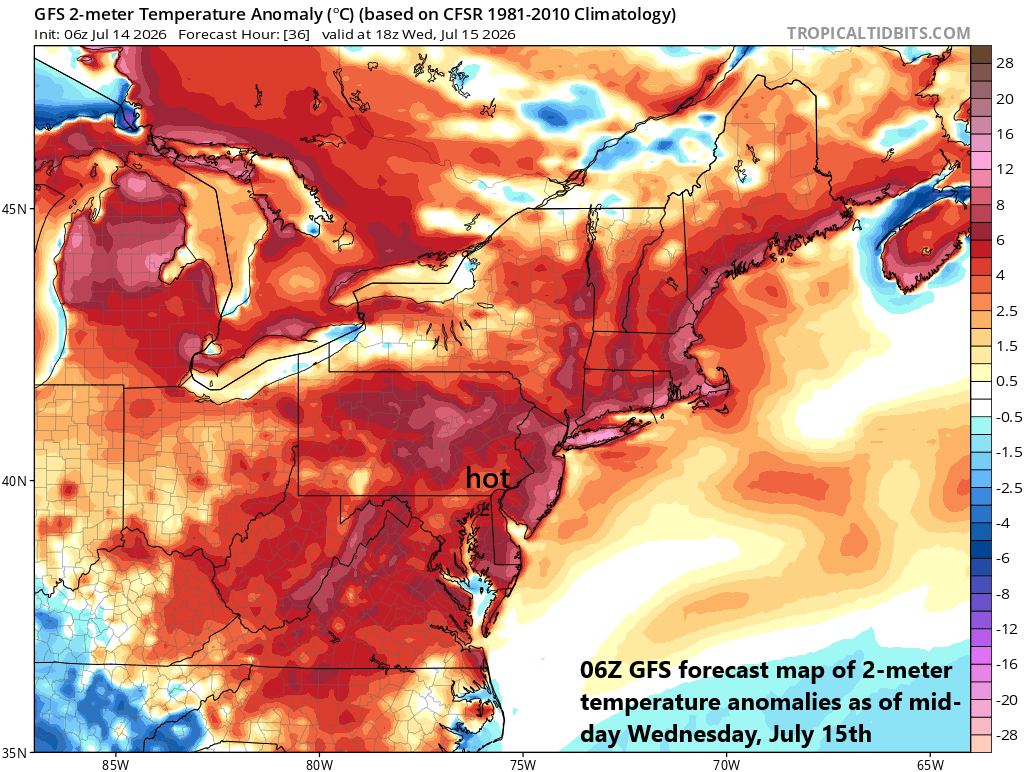
Wednesday could turn out to be the hottest day of the week in the DC-to-Philly-to-NYC corridor with near 100 degrees possible for afternoon highs. Map courtesy NOAA, tropicaltidbits.com
Before we get to the weekend event and whatever that brings us, hot weather will dominate the scene across the Mid-Atlantic and Northeast US. While not as intense or as long-lasting as the hot stretch earlier this month, this upcoming spell will feature at least one day (Wednesday) in which temperatures can top out pretty close to the century mark in the DC-to-Philly-to-NYC corridor. Indeed, tomorrow may turn out to be the hottest day of the week in DC, Philly and NYC, but it’ll remain quite hot as well on Thursday and Friday. Farther to the northeast, the hottest day of the week in Boston could turn out to be today with Tuesday afternoon temperatures likely reaching the upper 90’s. A deepening upper-level trough over southeastern Canada should knock down temperatures a bit on Wednesday and even more substantially by Thursday with highs likely confined to the 80’s up there.
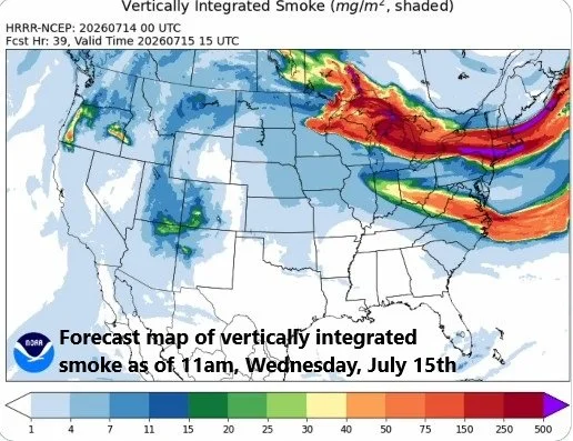
Some wildfire smoke can drop south and east into the Mid-Atlantic/NE US during the next couple of days as northwesterly flow develops aloft over the Great Lakes and this could dim the skies at times. Map courtesy NOAA
One final note, there has been some wildfire activity to our northwest in recent days, and some smoke can drop south and east into the Mid-Atlantic/Northeast US during at least the next 48 hours or so. This certainly can dim the skies at times and can act to shave off a few degrees to the afternoon high temperatures…something most will not complain about.
Meteorologist Paul Dorian
Arcfield
arcfieldweather.com
Follow us on Facebook, Twitter, YouTube
Video discussion: