Contact Us

Use the form on the right to contact us.

You can edit the text in this area, and change where the contact form on the right submits to, by entering edit mode using the modes on the bottom right. 


123 Street Avenue, City Town, 99999

(123) 555-6789

email@address.com


You can set your address, phone number, email and site description in the settings tab.
Link to read me page with more information.

backlit-stratus-clouds-2013-04-05.jpg

Blog

Weather forecasting and analysis, space and historic events, climate information

Filtering by Category: DC

1:00 PM | **Very significant rainfall with a tropical connection continues to threaten the Mid-Atlantic region for later this week and weekend**

Paul Dorian

GFS_6_day_total_rainfall.gif

Joaquin
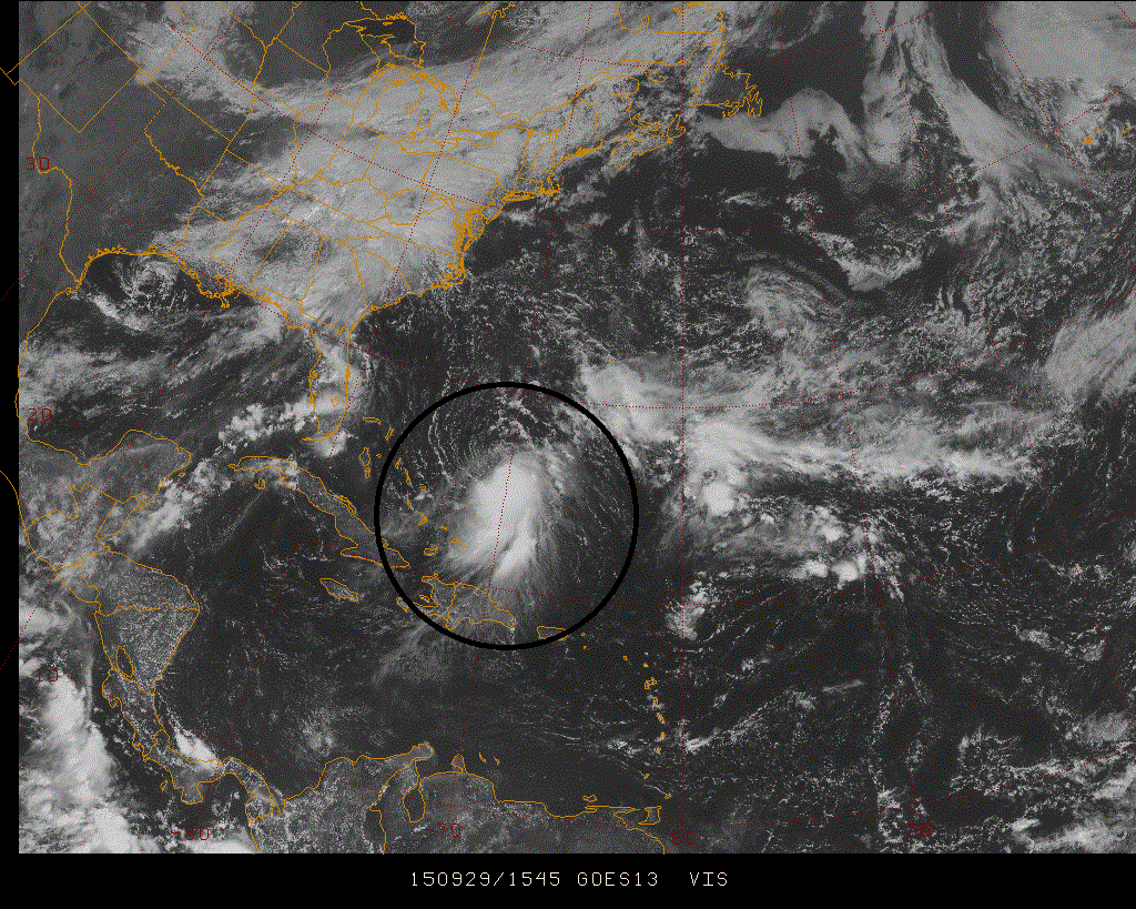
[Latest visible satellite image of Tropical Storm Joaquin; courtesy Penn State eWall]

Discussion

Quite a complicated weather pattern is unfolding for the Mid-Atlantic region with many players on the field and there are reasons for concern that it could all result in some very significant rainfall later this week and into the weekend. First, a strong cold front will slowly push through the region at mid-week and then will stall along the east coast. This frontal passage will generate some heavy rainfall in the Mid-Atlantic region from later tonight into Wednesday, but that is likely just the opening salvo. Low pressure now situated over the northeastern Gulf of Mexico is then likely to ride up along the stalled out frontal boundary zone generating additional significant rainfall later in the work week. Finally, the combination of a strong upper-level low in the Southeast US late this week and Tropical Storm Joaquin now spinning east of the Bahamas could bring more significant rainfall to the Mid-Atlantic region this weekend.

Tropical Storm Joaquin continues to churn at this hour in the waters east of the Bahamas with sustained winds at 35 knots. The development of the upper-level low later this week over the Southeast US has been consistently forecasted by the computer forecast models with Joaquin “pin wheeling” around it back towards the Mid-Atlantic coastline (“pin wheeling” is known in the meteorological community as the “Fugiwara” effect). Joaquin is currently in an area of wind shear which should suppress intensification somewhat in the near term, but once the shear weakens in 48 hours or so, it could very well strengthen into a hurricane later this week - perhaps even a category 2 or 3. One final note about Joaquin...it may or may not ever make a direct hit on the Mid-Atlantic coastline, but even if it does not, it could still have a major impact by supplying tremendous amounts of tropical moisture into the region.

Two other important factors in this unfolding weather event include strong and very slow-moving high pressure which will be situated across southeastern Canada at the end of the week and sea surface temperatures that are above-normal throughout the western Atlantic. Strong and very slow-moving high pressure across southeastern Canada at this time of year often results in tropical mischief along the US east coast. Above-normal sea surface temperatures in the western Atlantic (orange area in the map below) can only help with the intensification prospects for Tropical Storm Joaquin as tropical systems are fueled by warm waters.

SST_anomalies 
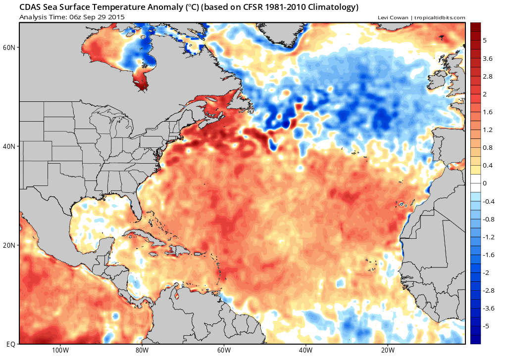
[Sea surface temperature anomalies in the western Atlantic; map courtesy "tropicaltidbits.com"]

Bottom line…our dry weather pattern of recent weeks will end in a dramatic fashion over the next several days. Very significant rainfall - on the order of 5 to 10 inches according to the latest GFS model run (below) - is on the table for the Mid-Atlantic region in the time period from later today through the upcoming weekend.

GFS_6_day_total_rainfall 
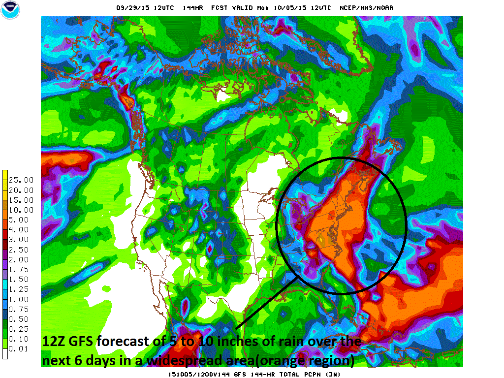
[12Z GFS total rainfall forecast over the next 6 days; courtesy NOAA]

Stay tuned.

Paul Dorian Vencore, Inc.

7:00 AM | *Heavy rain threat later today into early Wednesday as cold front slowly pushes through the region...tropical threat at end of week and/or during the weekend*

Paul Dorian

6-Day DC Forecast

Today

Mostly cloudy, still rather warm and muggy, showers likely after noon, possibly a thunderstorm, highs near 80 degrees

Tonight

Mostly cloudy, muggy, mild, occasional showers and possibly a thunderstorm, some of the rain can be heavy, lows in the upper 60’s

Wednesday

Showers likely, possibly a lingering thunderstorm, some of the rain can be heavy, cooler, low-to-mid 70’s

Wednesday Night

Mostly cloudy, cool, showers likely, upper 50’s

Thursday

Mostly cloudy, cool, showers possible, low-to-mid 60’s

Friday

Mostly cloudy, breezy, cool, rain possible and it could be significant, low-to-mid 60’s

Saturday

Mostly cloudy, breezy, cool, rain possible and it could be significant, low-to-mid 60’s

Sunday

Partly sunny, cool, still the chance for rain, mid-to-upper 60’s

Discussion

The overall weather pattern in recent days has generally been without significant rainfall, but heavy rain is a possibility on a couple of occasions during the next several days. A strong cold front will push some rain into the area later today, tonight and on Wednesday and some of that rain can be heavy at times. A few thunderstorms can also mix into the picture over the next 24 hours or so as the cold front slowly pushes through the region.

This frontal system will then stall out near the coastline and its boundary zone will act as a conduit for moisture to ride along later in the week and plenty of moisture will be available. In fact, a tropical depression near the Bahamas yesterday strengthened overnight into Tropical Storm Joaquin and there is a reasonable forecast scenario that brings this system back towards the Mid-Atlantic coastline at the end of the week and/or during the upcoming weekend. This type of track would certainly raise the prospects for more heavy rain and potential strong winds in at least coastal sections of the Mid-Atlantic. Stay tuned.

Video

httpv://youtu.be/xNXM4nZHbZA

3:00 PM | *Tropical connection is a late week/weekend concern*

Paul Dorian

12Z_Sat_Euro_t_t.png

12Z_Sat_Euro_t_t[12Z Euro model forecast for Saturday morning; courtesy tropicaltidbits.com]

Discussion

Our relatively dry weather pattern in the Mid-Atlantic region is coming to an end this week and there is some reason to be concerned about a potential heavy rain threat at the end of the week or over the weekend that could have a tropical connection. A strong cold front will push through the region on Wednesday generating heavy rain in the area along with possible thunderstorms. This front will stall out near the coastline and low pressure is likely to ride along the frontal boundary zone. There is a currently a tropical depression (#11) sitting well off the Southeast US coastline and it may get wrapped into this unfolding pattern. In fact, the latest Euro model (above) suggests the tropical system could strengthen later this week and then push back towards the Mid-Atlantic coastline (ala Sandy) over the weekend with heavy rain in its path. The key to this Euro model scenario is its forecast of a strong upper-level low in the Southeast US at the end of the week which "captures" the surface low pressure system and pulls it back towards the coast. Another model – NOAA's HWRF – which is specifically designed for hurricane forecasting has the track farther north than the 12Z Euro ultimately pushing the system into northern New Jersey (below) or thereabouts. Strong high pressure across southeastern Canada later this week does certainly allow for the possibility of a tropical system to “back in” towards the east coast, but the movement of the strengthening upper-level low is a difficult part of the forecast. Stay tuned.

HWRF_storm_track [Storm track of tropical system by NOAA HWRF model (in purple); courtesy NOAA]

7:00 AM | Strong cold front brings rain to the region later tomorrow into Wednesday - some of it can be heavy and maybe a thunderstorm - then much cooler air follows...more rain possible at week's end

Paul Dorian

6-Day DC Forecast

Today

Mostly cloudy, muggy, mild, patchy fog early, showers possible at times this afternoon, highs near 80 degrees

Tonight

Mostly cloudy, muggy, mild, chance for a couple of showers, patchy fog possible, lows in the upper 60’s

Tuesday

Mainly cloudy, still muggy and warm, showers likely, maybe a thunderstorm, near 80 degrees

Tuesday Night

Mostly cloudy, mild, showers likely, maybe a thunderstorm, some of the rain can be heavy, mid 60’s

Wednesday

Mostly cloudy and not as warm, periods of rain still possible early, some of the rain can be heavy, low 70’s

Thursday

Mostly cloudy, breezy, cooler, chance for showers, mid 60’s

Friday

Mostly cloudy, cool, chance for rain, low-to-mid 60’s

Saturday

Mostly cloudy, cool, chance for rain, low-to-mid 60’s

Discussion

A strong cold front will push through the region on Wednesday and it’ll likely generate some heavy rain later Tuesday into early Wednesday before a fall-like air mass follows for the latter part of the week. The front will stall near the coastline and this will allow low pressure areas to ride along the boundary zone at the end of the week perhaps bringing more substantial rainfall to the I-95 corridor.

7:00 AM | Onshore flow continues through the weekend and rain pushes northward into the DC metro region

Paul Dorian

6-Day DC Forecast

Today

Mainly cloudy, breezy, cool, highs in the low-to-mid 70’s

Tonight

Mostly cloudy, breezy, cool, chance for showers towards morning, lows in the upper 50’s

Saturday

Mainly cloudy, breezy, cool, showers likely, low 70’s

Saturday Night

Mostly cloudy, breezy, cool, rain likely, upper 50’s

Sunday

Mainly cloudy, breezy, quite cool, rain likely, near 70 degrees

Monday

Mostly cloudy, breezy, cool, still the chance for rain, mid-to-upper 70’s

Tuesday

Mainly sunny, warmer, near 80 degrees

Wednesday

Mainly sunny, pleasant, upper 70’s

Discussion

Strong high pressure from Canada is building southeastward and will combine with low pressure off the Mid Atlantic coastline to continue to produce an onshore flow of air into our area. The low pressure system will push slowly northwestward over the next couple of days and the result will be periods of rain in the DC metro region this upcoming weekend and perhaps lingering into Monday as well. Coastal locations could experience above-normal high tides, rip currents and even some beach erosion over the weekend given the expected long-lasting onshore flow of air and these effects will be exacerbated by the full “supermoon” which takes place on Sunday.

Video

httpv://youtu.be/AfHeoI4xatM

7:00 AM | Onshore flow on Friday, Saturday and Sunday with an increasing shower threat

Paul Dorian

6-Day DC Forecast

Today

Mainly sunny, warmer, highs near 80 degrees

Tonight

Partly cloudy, cool, lows in the upper 50’s

Friday

Mainly cloudy, breezy, cool, chance for showers late, low-to-mid 70’s

Friday Night

Mostly cloudy, breezy, cool, chance for showers, mid-to-upper 50’s

Saturday

Mainly cloudy, breezy, cool, chance for showers, low 70’s

Sunday

Mainly cloudy, breezy, cool, chance for showers, low 70’s

Monday

Partly sunny, cool, still the chance for showers, mid 70’s

Tuesday

Partly sunny, pleasant, upper 70’s

Discussion

Strong high pressure from Canada will build southeastward over the next 24 hours and this will combine with low pressure off the Mid Atlantic coast to continue a persistent onshore flow of air into our area. The low pressure system will push slowly northwestward over the next couple of days and the result will be an increasing chance for showers around here as we head into the weekend. Coastal locations could experience above-normal high tides, rip currents and even some beach erosion over the weekend given the expected long-lasting onshore flow of air and these effects will be exacerbated by the full “supermoon” which takes place on Sunday.

7:00 AM | Nice weather for today and Thursday...persistent onshore flow Friday, Saturday and Sunday with the threat for showers

Paul Dorian

6-Day DC Forecast

Today

Mainly sunny, warmer, highs rebound to the upper 70’s after a cool start

Tonight

Mainly clear, cool, lows in the low-to-mid 50’s

Thursday

Mainly sunny, nice, near 80 degrees

Thursday Night

Partly cloudy, cool, near 60 degrees

Friday

Mainly cloudy, breezy, cool, showers possible, low-to-mid 70’s

Saturday

Mostly cloudy, breezy, cool, showers possible, low 70’s

Sunday

Mostly cloudy, breezy, cool, showers possible, low 70’s

Monday

Partly sunny, cool, still the chance for showers, low-to-mid 70’s

Discussion

High pressure will build back into the region for today and Thursday and the resultant increase in sunshine will boost afternoon temperatures each day to noticeably warmer levels compared to the past couple of days. Low pressure off the Carolina coastline will push northward at a snail's pace at the end of this week and weekend and it will combine with strong high pressure to the north to generate a persistent onshore flow of air. Showers are beginning Friday and right through the upcoming weekend in the DC metro region; especially, in the southern and eastern sections of the area. Coastal locations could see some above-normal high tides, rip currents and even beach erosion over the weekend given the expected persistent onshore flow of air and all of these conditions will be exacerbated by the full "supermoon" on Sunday.

Video

httpv://youtu.be/JmIW3cFGDgE

2:45 PM | Persistent onshore flow, full “supermoon”, and potential coastal low pose problems this weekend/early next week for at least parts of the Mid-Atlantic region

Paul Dorian

gfs_mslp_pcpn_frzn_us_24
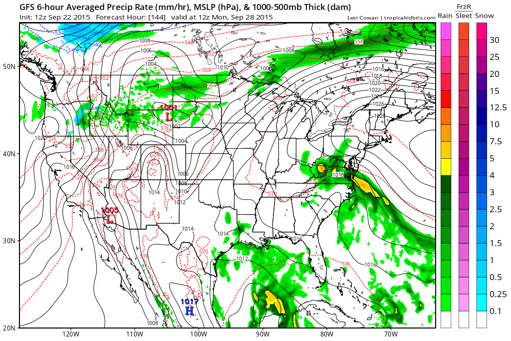
[12Z GFS forecast map for Monday morning; courtesy NOAA]

Discussion

High pressure will reassert itself in the Mid-Atlantic region during the next couple of days and sunshine should return in full force which will help boost afternoon temperatures to noticeably warmer levels. At the same time, abundant moisture will continue to reside just off the east coast. This area of moisture will push northward at a snail’s pace over the next few days at the same time strong high pressure slides to our north. Eventually, a significant rain event could very well occur in at least parts of the Mid-Atlantic region. The possible timing for this rain event is in the Sunday/Monday time period, but a quicker arrival of the moisture cannot be ruled out. The 12Z GFS forecast map above for Monday morning shows an area of precipitation (greens, yellows) in the southern part of the Mid-Atlantic region and there is an impressively strong flow of moist ocean air right into the area.

CPhdlofXAAAeSOt 
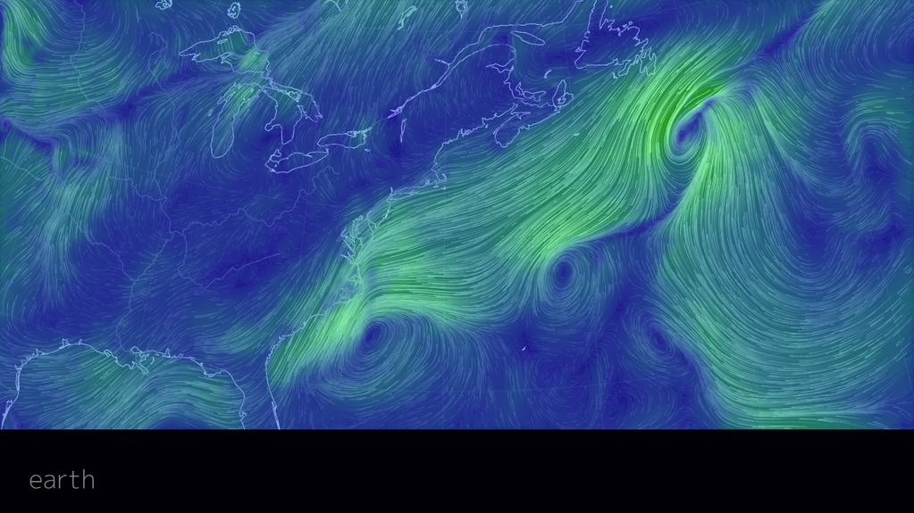
[Current "wind flow" map shows large fetch over the Atlantic Ocean; courtesy earth.nullschool.net]

Whether this significant rain event ever materializes, this persistent ocean flow of air will likely to lead to heavy surf, rip currents and beach erosion along coastal sections by the weekend. The wind flow map above shows a long fetch of onshore flow already in place along the Mid-Atlantic coastline (courtesy earth.nullschool.net). All of these coastal effects will be made worse this weekend by higher-than-normal tides as the moon will reach full “supermoon” status on Sunday. A “supermoon” occurs 6 times this year and is defined as when the new or full moon comes within 224,834 miles of Earth as measured from the centers of the moon and Earth. A full “supermoon” is 12 to 14 percent brighter than a full moon in its most distant approach to Earth. Stay tuned...especially along coastal locations.

7:00 AM | Still cool, damp today...nicer Wed/Thurs...end of week and weekend questionable

Paul Dorian

6-Day DC Forecast

Today

Mainly cloudy, cool, chance for an early shower, highs not far from 75 degrees

Tonight

Partly cloudy, cool, lows in the low-to-mid 50’s

Wednesday

Mainly sunny, warmer, upper 70’s

Wednesday Night

Partly cloudy, cool, low-to-mid 50’s

Thursday

Mainly sunny, nice, upper 70’s

Friday

Mostly cloudy, cool, showers likely, low 70’s

Saturday

Mostly cloudy, cool with the threat for more showers, breezy, cool, low-to-mid 70’s

Sunday

Mostly cloudy, cool, still a shower threat, mid 70’s

Discussion

High pressure sits over the Northeast US today and low pressure is located off the Southeast US coastline. The combination of the two systems has produced an ocean flow of air in our area and it will continue to generate some clouds and hold down temperatures. Increasing amounts of sunshine on Wednesday and Thursday will boost temperatures to noticeably warmer levels. The low pressure system off the SE US coastline will then drift back towards the Mid-Atlantic coast by the weekend and showers will threaten at least parts of the Mid-Atlantic region.

7:00 AM | Dry spell comes to an end...fall-like temperatures for much of the week...coastal low threatens at end of week and weekend

Paul Dorian

6-Day DC Forecast

Today

Mainly cloudy, quite cool, showers likely, highs no better than 70 degrees

Tonight

Mostly cloudy, cool, more showers likely, lows in the mid-to-upper 50’s

Tuesday

Mostly cloudy, still cool with the chance for a couple showers, mid 70’s

Tuesday Night

Partly cloudy, cool, upper 50’s

Wednesday

Mainly sunny, warmer, upper 70’s

Thursday

Mostly sunny, pleasant, near 80 degrees

Friday

Mostly cloudy, cooler, periods of rain likely, low-to-mid 70's

Saturday

Mostly cloudy, cool, chance for more rain, low-to-mid 70's

Discussion

High pressure dominated our weather pattern for much of last week and a new high pressure system is trying to take control early this week. However, an ocean flow of air out of the northeast and an area of moisture to our southwest will overcome the high pressure and bring our dry spell to an end. Showers are likely today, tonight and perhaps even into Tuesday in the DC metro region and temperatures will be quite fall-like into mid-week. It'll turn warmer on Wednesday and Thursday with the return of sunshine. Late this week and into the weekend, a coastal low pressure system will drift back towards the Mid-Atlantic coastline from off-shore and the result could be some rain and wind late in the week and into the weekend in the I-95 corridor region from DC-to-Philly-to-NYC.