
12:00 PM | ***Mesoscale banding setting up as coastal storm intensifies***
Paul Dorian

Heavier band of snow reaching the DC metro region at this time
A healthy environment is allowing for quick intensification of a coastal storm today and heavy small-scale (a.k.a., mesoscale) snowbands are forming on the storm’s northwestern flank. One such heavy snow band is moving into the DC metro region (arrows) right around the noon hour and this same type of banding should reach SE PA early this afternoon and then NYC by mid-to-late afternoon. Certainly, it is best to avoid driving during snowfall associated with these bands as visibility will drop quickly and accumulations on the roadways will be rapid. This banding will mean snowfall rates will be quite variable from one place to another and from one time to another. Another area of interest on radar is across southwestern Virginia (circled area). It is this area that holds some potential for additional bands of snow to reach DC, Philly and NYC later in the day and it will be monitored for its radar echo movement and (potential) expansion.
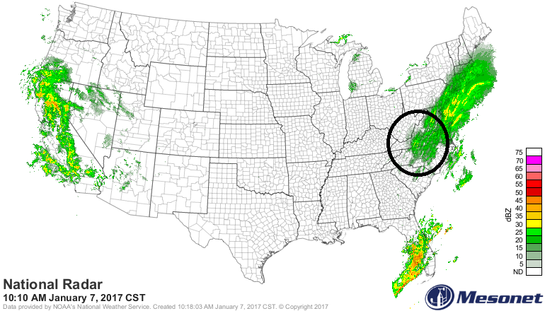
Area of radar echoes in circled region can affect DC, Philly, NYC later today
Expected snow totals continue to follow earlier thinking with more to the south and east of I-95 and less to the N and W. Specifically, 1-3 inches is likely in the immediate DC, Philly metro regions (“metro region” defined as the city and its immediate surrounding counties), 3-6 inches just to the south and east of these cities (e.g., interior southern and central NJ, southern Maryland) and 6-12 inches is possible at the coastline (e.g., Cape May, NJ, Atlantic City, NJ, Ocean City, MD). In the NYC metro region, a general 3-5 inches can be expected. Lightning strikes continue to accompany this intensifying coastal storm system (map below).

Latest lightning strikes indicating an energetic atmosphere
Ending times are roughly as follows: mid-afternoon in DC, late afternoon in Philly, early evening around NYC. Following the storm, brutal cold air will flood into the eastern US on northerly winds and temperatures in the northern and western suburbs of DC, Philly and NYC could drop to 10 degrees by early Sunday morning and then again early Monday (single digits are not out of the question).