2:00 PM | *Major coastal storm threat continues for the Mid-Atlantic/Northeast US*
Paul Dorian

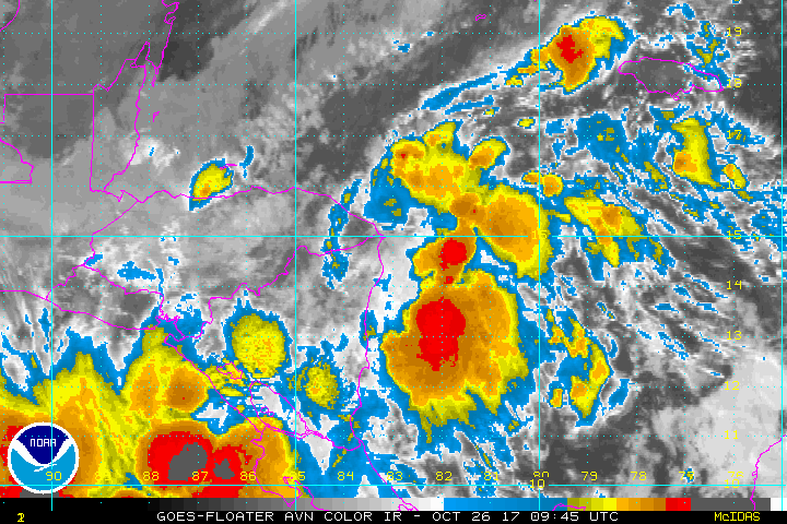
Colorized IR imagery loop over the western Caribbean Sea featuring a batch of showers and thunderstorms associated with "Invest 93L". Some of this tropical moisture is likely to become entrained into an intensifying storm this weekend near the Mid-Atlantic coastline. Courtesy NOAA
Overview
A major coastal storm is in the works for the Sunday/Monday time frame in the Mid-Atlantic/Northeast US and it will likely feature the entrainment of tropical moisture to its south and east and the intrusion of cold, polar air to its west and north. This potential storm could bring several inches of rain to portions of the Northeast US, significant rainfall to the DC-Philly-NYC corridor, and even some accumulating snow to the higher elevations of the Appalachians.

Deep upper-level trough of low pressure will change orientation from Sunday morning ("neutral", left map) to Sunday evening ("negative", right map) indicative of rapid intensification; courtesy tropicaltidbits.com, NOAA/EMC
Details
Deep upper-level trough of low pressure will drop southeastward into the Tennessee Valley on Sunday morning and it will have a relatively “neutral” tilt to its axis (i.e., north-to-south orientation). As a result of a strong blocking pattern in the northern Atlantic, this trough will "forced" to slow down and intensify rapidly as it develops a “negative” tilt to its axis by Sunday evening (i.e., northwest-to-southeast orientation) which will be correlated with in an intensifying surface storm near the Mid-Atlantic coastline. As far as the Mid-Atlantic's I-95 corridor is concerned, this type of "rapidly intensifying" scenario would likely produce a coastal storm with a bigger impact on New York City, for example, as compared with Washington, D.C.; however, all areas in this "big city" corridor should receive a significant rainfall.

12Z GFS forecast map of 850 mb temperature anomalies on Sunday evening with cold air pouring in on the west side of the coastal storm and warm, tropical air its east side; courtesy tropicaltidbits.com, NOAA/EMC
Tropical moisture associated with “Invest 93L” will ride northward over the next few days from the Caribbean Sea into the western Atlantic and as the deepening upper-level trough intensifies and reaches the eastern US, it will draw in some tropical moisture.

12Z Euro forecast map of precipitable water for early Sunday afternoon. Plume of high moisture content along the eastern seaboard is associated with tropical moisture from "Invest 93L" that will get entrained into an intensifying coastal storm. Map courtesy weather.us (Dr. Ryan Maue)
At the same time, cold, polar air will be charging southeastward on the northwest flank of the intensifying coastal storm and some of the rain could ultimately changeover to snow over the higher elevations of West Virginia and southwestern Pennsylvania.

NOAA's forecast map of 5-day precipitation amounts which are primarily as a result of the upcoming weekend coastal storm system.
Following the passage of the storm, strong northwest winds will usher in quite chilly air on Monday in the I-95 corridor and this cool down will stick around for awhile. In fact, Halloween Day (Tuesday) looks to be cooler-than-normal in the Mid-Atlantic and additional cold air outbreaks will likely make for a "below-normal" first half of November in much of the central and eastern US – quite a change from October which has been well above normal.
Meteorologist Paul Dorian
Vencore, Inc.
vencoreweather.com