
3:25 PM | *Major coastal storm near the Mid-Atlantic coastline by early Sunday night*
Paul Dorian
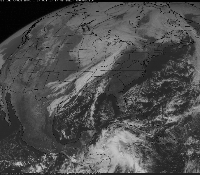
Latest GOES-16 visible satellite image featuring deep upper-level trough heading into the Tennessee Valley and a batch of showers and thunderstorms over the Caribbean Sea associated with "Invest 93L". Image courtesy NOAA/GOES
Overview
A major coastal storm is still in the works for later Sunday/Sunday night in the Mid-Atlantic/Northeast US and it will contain some tropical moisture from “Invest 93L” and cold air will be pouring in on its western flank into the Tennessee and Ohio Valleys. This storm should bring significant rainfall to the DC-Philly-NYC corridor with the highest amounts on the northeast end and the lowest amounts to the southwest. There will likely be two separate periods of strong winds in the Mid-Atlantic from this storm – one in the warm sector and the second following the passage of the strong cold front.

Loop of total precipitable water with lots of moisture (red, yellow) over the Caribbean Sea. This batch of moisture will soon push northward and some of it will get entrained in an intensifying coastal storm; image loop courtesy University of Wisconsin/CIMSS
Details
Three key factors will play a role in the formation of a major coastal storm by Sunday evening: 1) blocking pattern in the upper-atmoshere over the North Atlantic, 2) tropical moisture riding northward from the Caribbean Sea (Invest 93L) and into the western Atlantic, and 3) and cold air intrusion into the Tennessee and Ohio Valleys.
The latest water vapor loop indicates there is a lot of moisture over the Carribbean Sea associated with an intensifying tropical system and it is about to push to the north. Heavy rain is likely to break out over Cuba and much of southern Florida over the next 24 hours as this moisture pushes to the north and there is a chance that Invest 93L intensifies into tropical depression or storm status. If it were to become a named tropical storm, it would be known as “Phillipe”.
Deep upper-level trough of low pressure is already seen on the latest visible satellite image over the center of the country and it will slide to the Tennessee Valley by Sunday morning. At first this trough will have a relatively “neutral” tilt to its axis (i.e., north-to-south orientation), but then as a result of the strong blocking pattern over the north Atlantic, this trough will intensify rapidly and develop a “negative” tilt to its axis (i.e., northwest-to-southeast orientation) by Sunday evening. This will all result in a strong and intensifying surface low pressure system just off the coastline of the Delmarva Peninsula/southern New Jersey by early Sunday evening.
Winds will become quite strong with this storm in the Mid-Atlantic region with two bursts likely. The first burst of wind should take place ahead of the strong cold front and will feature strong south-to-southeast gusts from late Saturday into Sunday. The second burst of winds will take place late Sunday night/early Monday with strong west-to-northwest winds following the strong cold frontal passage. Strongest winds during this event are likely to occur from the coastline of New Jersey to across Long Island and into southern New England. The coastal storm will turn north from the coastline of the Mid-Atlantic not turn out-to-sea – all as a result of the strong blocking over Greenland - and ultimately head into the Hudson Valley region of New York.
Meteorologist Paul Dorian
Vencore, Inc.
vencoreweather.com
Video discussion: