
11:00 AM | **Winter is coming…significant pattern change begins late next week in the eastern US**
Paul Dorian
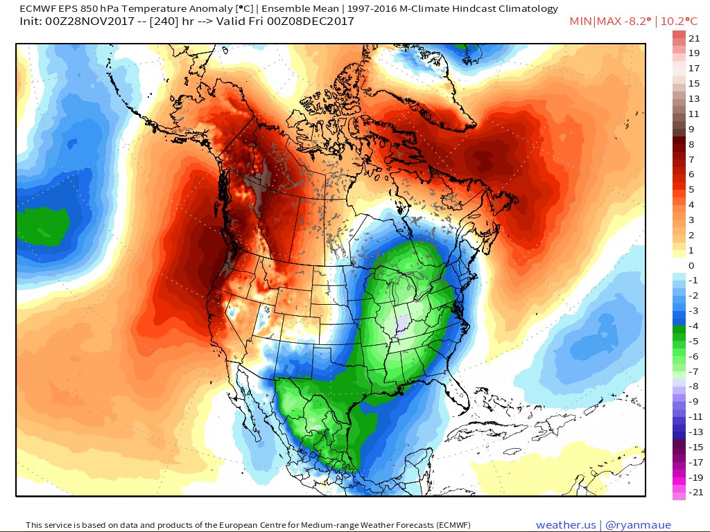
The 10-day (Friday, December 8th) forecast map of 850 mb temperature anomalies from the 00Z Euro Ensemble (EPS) featuring colder-than-normal conditions (blue, green) throughout the eastern half of the nation. Map courtesy "weather.us" (Dr. Ryan Maue).
Overview
If you still have to put up outside Christmas lights and rake some more leaves then this weekend may be the last chance for awhile with seasonal temperatures in the eastern US. There are increasing signs for a major pattern shift to winter weather conditions in the central and eastern US beginning late next week that will feature a combination of strong upper-level blocking over the northern latitudes and a deep trough of low pressure over the central/eastern US. Once this pattern sets up it could very well stick around for much of the month of December which would, of course, increase our odds for a white Christmas. Before that, however, the overall weather pattern will be rather quiet for the next week or so featuring mild conditions for the next two days and then a rather unimpressive cold frontal passage that will bring us seasonably chilly air for the end of the week, weekend, and early part of next week.

The 500 mb height anomaly forecast map from the 00Z Euro Ensemble (EPS) averaged over the next 5 days (i.e., days 1-5) featuring higher-than-normal heights (orange) throughout much of the US along with a rather benign zonal (west-to-east) flow of air. Map courtesy "tropicaltidbits.com".
Discussion
The next several days will feature above-normal heights across much of the US and a zonal flow of air (west-to-east) which will keep temperatures anywhere from well-above normal to normal for most parts of the country. There actually is some high-latitude blocking at the current time with abnormally strong high pressure across Greenland, but this will weaken by the weekend and any truly cold air masses over the next few days will be confined to Canada.
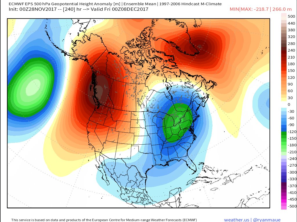
The 10-day (Friday, December 8th) forecast map of 500 mb height anomalies from the 00Z Euro Ensemble (EPS) featuring strong high-latitude blocking over Greenland and western Canada (orange, red), and a deep upper-level trough of low pressure (blue) centered over the eastern half of the nation. Map courtesy "weather.us" (Dr. Ryan Maue).
By the middle of next week, an upper-level trough will begin to form over the central US and this will ultimately expand into the eastern US by the latter part of next week. As a result, temperatures are likely to trend downward in the central and eastern US later next week and the potential for storms is likely to grow. Once this type of upper-level pattern becomes established with the combination of strong blocking over the northern latitudes, a deep upper-level trough over the central and eastern US, and strong ridging over the US and Canadian west coasts, it is likely to stick around for awhile. In fact, there is potential for a cold and perhaps stormy pattern to begin later next week and continue through much of the month of December - increasing our odds for a white Christmas in the Mid-Atlantic region.
Stay tuned.
Video discussion on the upcoming significant pattern change:
Meteorologist Paul Dorian
Vencore, Inc.
vencoreweather.com