
9:15 AM (Saturday) | ****Major storm threat continues for late Monday night/Tuesday…storm track still an important issue****
Paul Dorian

00Z GFS forecast map for early Tuesday; courtesy tropicaltidbits.com, NOAA/EMC
Saturday morning overview
All signs continue to point to a major storm along the Mid-Atlantic coastline by early Tuesday and it could result in a substantial snowfall for parts the I-95 corridor. This storm looks like it will have the potential to produce 1-2 feet of snow, but exactly where that heaviest snowfall sets up is still in question as the storm track could be anywhere from just inland to just off the Mid-Atlantic coastline - and this difference could be crucial to the I-95 corridor. The end result is that there is likely to be a sharp snow accumulation gradient with this storm – perhaps setting up from right along Route I-95 to the coast. By the way, the last great snowstorm during the month of March for the Mid-Atlantic region was the so-called "Storm of the Century" in March 1993.
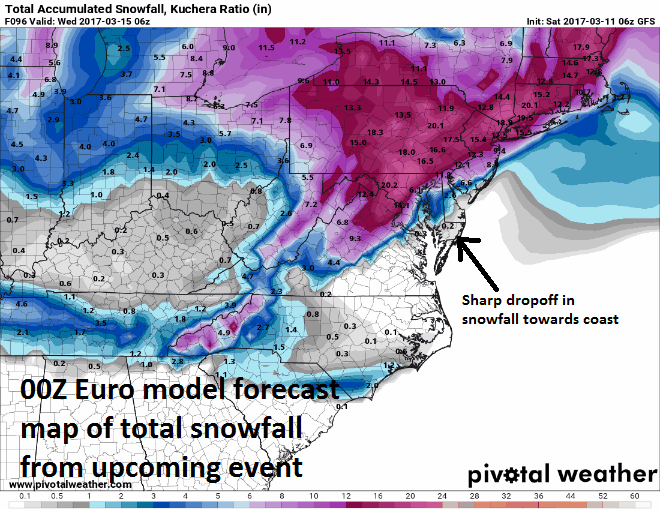
Total snowfall forecast map by the 00Z Euro; courtesy Pivotal Weather
There is going to be a “sweet spot” where the precipitation is "all" or "mostly snow" and 1-2 feet could possibly accumulate and perhaps this “sweet spot” will be in the northern and western suburbs of the big cities with mixing an issue from I-95 to the coast. The storm is likely to be a slow mover and there can even be some residual snow or snow shower activity as late as the day on Wednesday in the Mid-Atlantic region.

Many record or near record lows this morning in the Northeast US; courtesy coolwx.com
Discussion
Very cold air for this time of year is now firmly entrenched in the area and there are some record or near record lows in the Northeast US. It stays cold right through the day on Monday at which time low pressure will be dropping southeastward towards the Ohio Valley. By late Monday night/early Tuesday, a coastal low will begin taking over as the primary low probably along the South Carolina coastline. This low will intensify as it turns northeast likely reaching a position in the region between the Delmarva Peninsula coast to about 50 miles off the coast – this west-to-east spread in potential location will be crucial to where the “sweet spot” sets up with all or mostly snow and where there will be more of a mix between accumulating snow and rain/ice.

Upper-level features that will help spawn the powerful coastal storm; courtesy NOAA/EMC
The upper level features that will help spawn this major and slow-moving system will eventually coalesce into one deep upper-level trough in the Northeast US. The strength, location and orientation of these two pieces of upper-level energy will be critical. As of early Tuesday, there is one reflection of upper-level energy along the Mid-Atlantic coast and another one over the Great Lakes.
Stay tuned, this is an active and complicated pattern with big potential. One final note, turn the clocks ahead an hour early tomorrow.
Meteorologist Paul Dorian
Vencore, Inc.
vencoreweather.com