12:40 PM | **Active weather pattern to bring heavy rain to the Mid-Atlantic, significant snow to interior upstate NY/New England/Colorado Rockies, and severe weather to the Midwest, southern US**
Paul Dorian
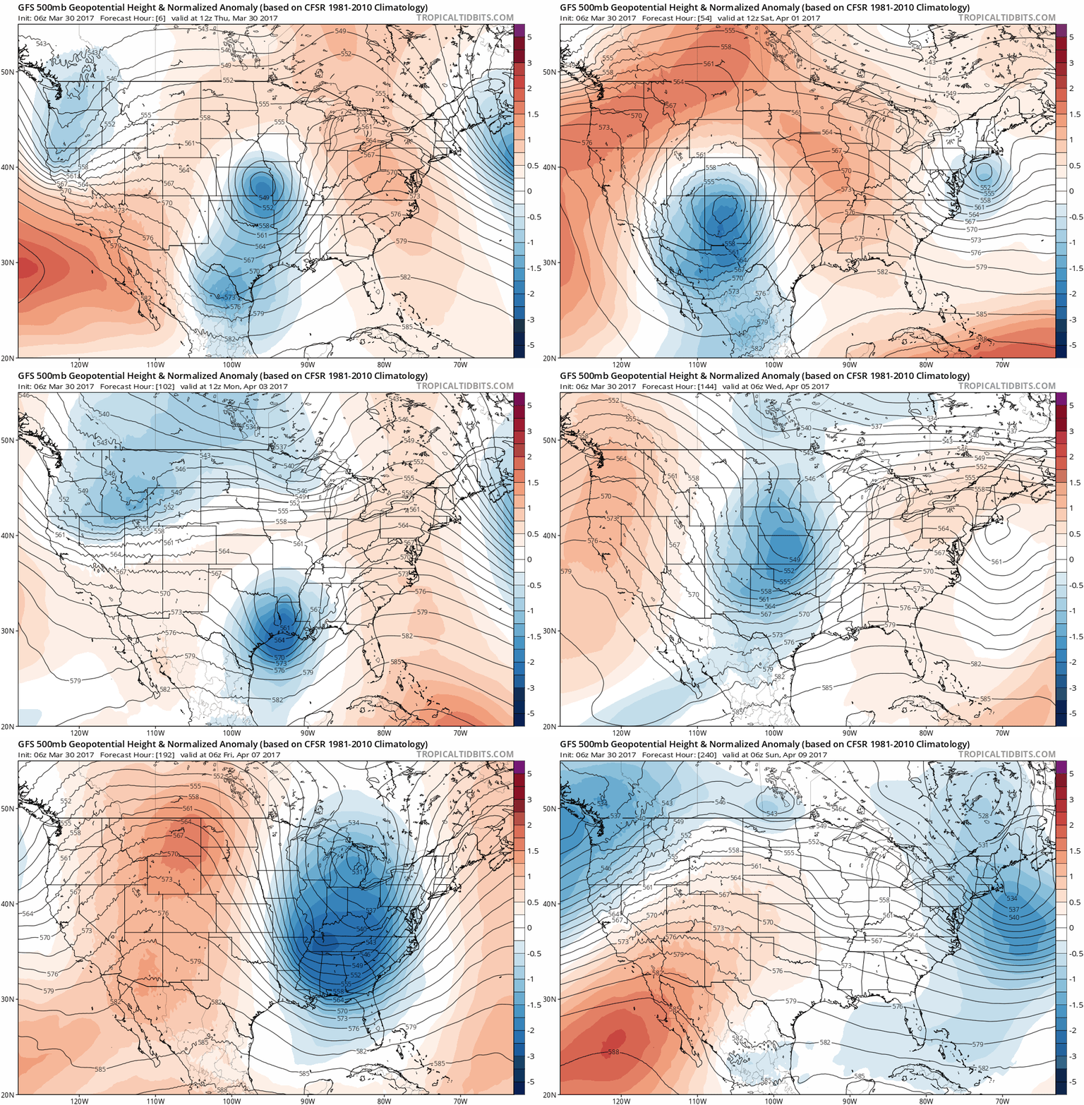
06Z GFS forecast loop over the next ten days of upper-levels troughs (in blue) in 6-hour increments; maps courtesy tropicaltidbits.com, NOAA/EMC
Overview
The next week to ten days will feature numerous strong upper-level waves of energy traveling from the eastern Pacific Ocean all way across to the northeastern US on a fairly regular basis averaging every few days or so. Today's tranquil weather in the Mid-Atlantic region will soon give way to a major rain event for the DC-to-Philly-to-NYC corridor that could result in more than two inches of rain by early Saturday in some spots. This active weather pattern will not only bring soaking rain to the Mid-Atlantic as we close out this current work week, but there will be another chance for significant rain early next week and then yet another chance late next week. In addition to the heavy rain in the Mid-Atlantic, this active pattern will bring substantial springtime snowfall to interior upstate New York and New England as well as across the Colorado Rockies in the western US. Severe weather will also be a major consequence of this energetic weather pattern with numerous threats coming to the Midwest, south-central, and southeastern US.
NOAA forecast map of total precipitation amounts (liquid) over the next 7 days
Significant Rain Threats in the Mid-Atlantic
Here in the Mid-Atlantic region, a soaking rain event is going to arrive after midnight and continue into early Saturday and the result could be more than two inches of rain in some spots. The rain will fall heavily at times on Friday and there can even be a strong thunderstorm or two in the mix. Any lingering rain and clouds early Saturday will give way to mainly cloudy skies and Sunday is likely to actually turn out to be a pretty decent day. However, the next wave in a series of waves traversing the country from west-to-east could bring more rain to the DC-to-Philly-to-NYC corridor later Monday into Tuesday. Following that early week threat, there are signs for another big event here in the Mid-Atlantic region late next week – most likely in the later Thursday/Friday time period - and this one looks like it could be followed by an impressive cold air outbreak in the eastern US.
Total snowfall over the next ten days as predicted by the 12Z GFS; map courtesy tropicaltidbits.com, NOAA/EMC
Significant Snow Threats in the interior Northeast US and Colorado Rockies
The air will remain cold enough for significant accumulating snow to fall in the Colorado Rockies during this active weather pattern as well as across interior sections of upstate New York and New England. In fact, there is the strong likelihood for a foot or more of snow by the early part of the weekend in areas just west of Denver, Colorado and in the higher elevations of interior Vermont, New Hampshire and northern New York. Snow accumulation is quite dependent on elevation this time of year so these higher elevation locations are the favored spots for significant accumulations. In fact, ski resorts in Colorado and New England, for example, should be going strong right into the middle part of April and they’ll be calling this the "spring that just won’t begin" in both of these regions. An interesting note, Boston, MA is likely to have an average monthly temperature that is colder in March than either January or February.
Today's severe weather threat concentrated from in the region from the the Upper Midwest to the Gulf of Mexico; map courtesy NOAA/SPC
Severe Weather Threats
This active pattern will feature warm, humid air surging northward from the Gulf of Mexico, entrenched cold air across the Northeast US, and vigorous upper-level waves of energy moving west-to-east across the country and this combination will result in many severe weather threats across the Midwest, south-central, and southeastern US. Today, for example, there will be an enhanced threat for severe thunderstorms including isolated tornadoes from the Midwest southward to the Gulf region including Louisiana, Mississippi and Alabama. The next wave in a series of waves will bring another round of showers and thunderstorms to this same general region of the country later in the weekend into early next week and this will also have a severe weather component.
Meteorologist Paul Dorian
Vencore, Inc.
vencoreweather.com
Extended video discussion:


