
11:50 AM | *Large scale precipitation event next few days to impact much of the nation*
Paul Dorian
A powerful jet streak will contribute to a large-scale precipitation event across much of the nation during the next few days; courtesy NOAA/EMC, tropicaltidbits.com
Overview
A strong cold front will slowly push across the nation over the next few days and it’ll have an important impact on a wide area from the Rockies to the eastern seaboard. A powerful digging jet stream in the upper atmosphere will help to carve out a deep upper-level trough by late in the week and the result of this overall unfolding weather pattern will be heavy snow across the Rockies, heavy rain in the Ohio and Tennessee Valleys, and a severe weather threat across much of the southern US. Rain will spread into the eastern US by Thursday night as the front continues to slide slowly to the east. The rain will likely continue into Friday night in the eastern US - possibly heavy at times - as low pressure forms along the frontal boundary zone.

Significant snowfall is likely next 24 hours across the central Colorado Rockies; courtesy NOAA/WPC
Discussion
A strong cold front is pushing across Colorado at mid-day and its passage will usher in much colder air that will contribute to significant snowfall in many of the central Colorado Rockies where more than a foot can fall by early tomorrow in some of the highest elevation spots. As this strong cold front slides eastward on Wednesday and Thursday, showers and thunderstorms will break out from the Great Lakes/Ohio Valley southward to the western and central Gulf coastal regions. Heavy rainfall on the order of at least a few inches is quite likely in this particular region and severe weather will become a threat on Wednesday afternoon across eastern Texas and the lower Mississippi Valley and then shift eastward to the Tennessee Valley and northern Gulf coast on Thursday.

Severe weather will become a threat on Wednesday and Thursday across much of the southern US; courtesy NOAA/SPC
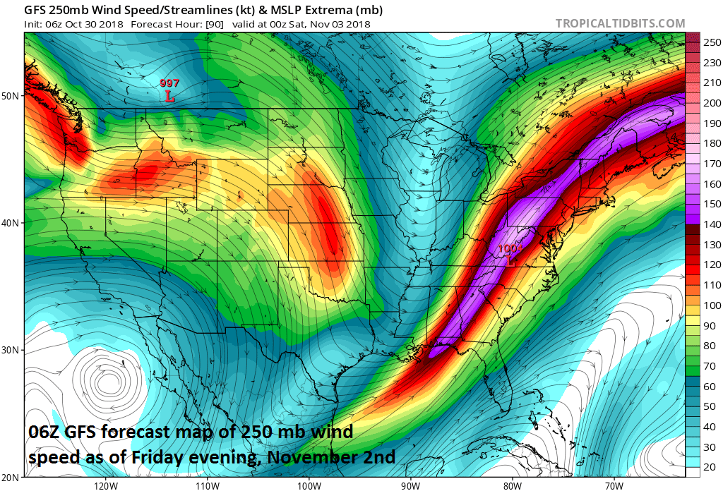
By Thursday evening, rainfall associated with the strong cold frontal system and associated powerful jet streak will push into the eastern states and the threat for rain will continue on Friday as well as low pressure rides along the frontal boundary zone. Some of the rain is likely to fall heavily at times in the eastern US and given the strong dynamics in the atmosphere associated with a powerful jet, strong thunderstorms will be on the table as well.

00Z Euro ensemble forecast map of 500 mb height anomalies features a deep upper-level trough at the end of the week; courtesy ECMWF, tropicaltidbits.com
Once the front clears the east coast at week’s end, cooler air will return and the upcoming weekend is likely to feature below-normal temperatures along with generally rain-free conditions. One final note, this upcoming weekend will be the time to “turn-the-clocks” back so get ready for darkness to arrive earlier in the evening beginning on Sunday.
Meteorologist Paul Dorian
Perspecta, Inc.
perspectaweather.com