12:00 PM | **Wintry precipitation threat on Thursday as strong coastal storm develops**
Paul Dorian
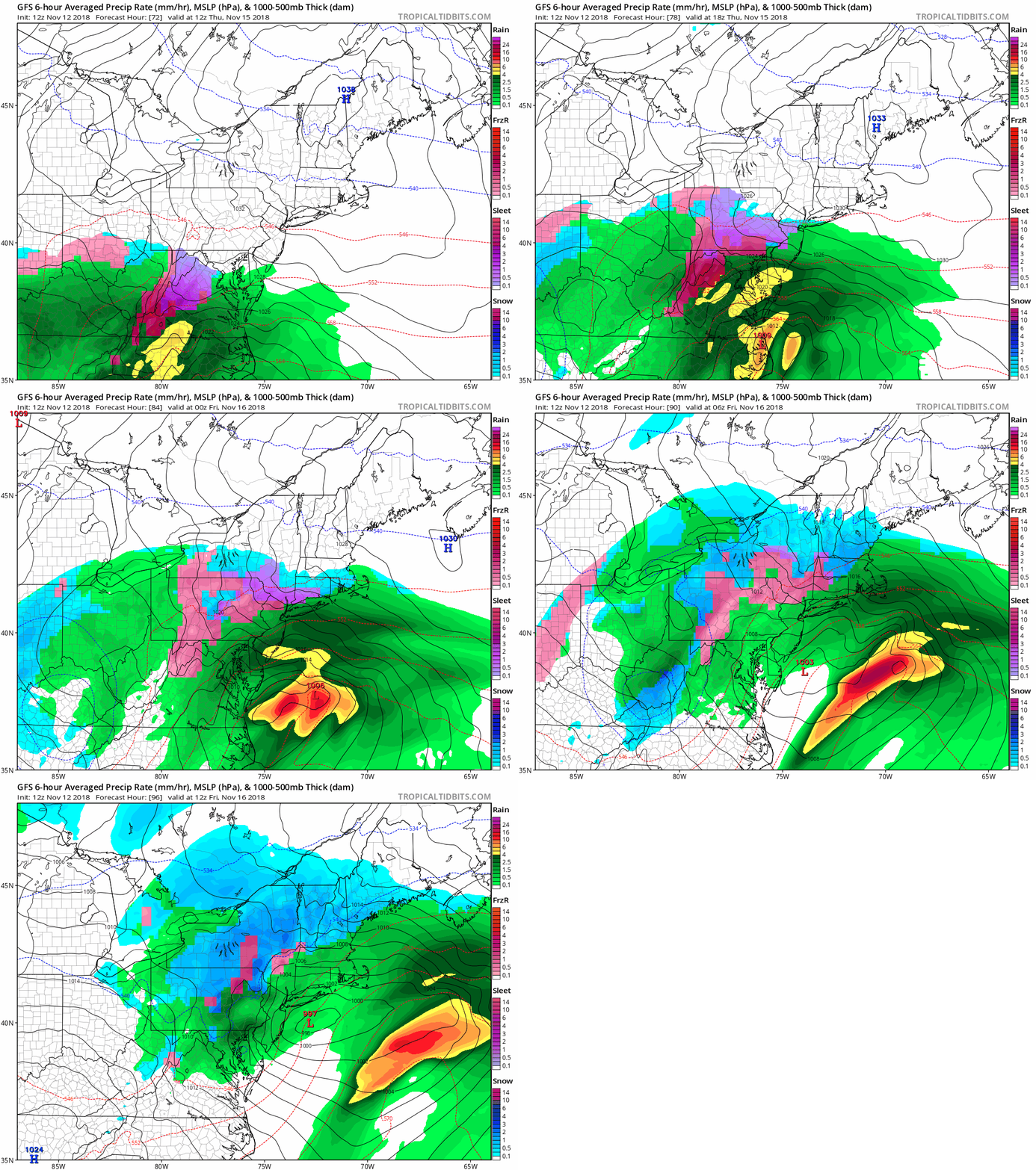
12Z GFS surface forecast maps from Thursday morning (hour 72) until Friday morning (hour 96) in 6-hour increments with wintry precipitation (i.e., snow-blue, sleet-purple, freezing rain-pink) seen from I-95 to points north and west; courtesy NOAA/EMC, tropicaltibits.com
Overview
Our active and cold weather pattern of recent days will continue through this week and there is the real possibility of some wintry precipitation for the first time this season in the DC-to-Philly-to-NYC corridor. Moisture associated with a strong coastal storm will arrive in this area on Thursday and cold air will be locked in place and anchored by sprawling high pressure over the Northeast US. As a result, the threat exists in the metro regions of DC, Philly and NYC of sleet, freezing rain and/or snow at the onset of this upcoming late week event with the highest probabilities of something frozen in the northern and western suburbs. Following the passage of the late week storm, yet another cold air mass will drop southeastward from central Canada and into the Mid-Atlantic region during the upcoming weekend.
Lots of moisture is headed this way for storm #1 of the week…rain will fall from late today into early Tuesday in the I-95 corridor; courtesy NOAA, College of DuPage
Details
There are two storms to deal with in the I-95 corridor during the next five days or so with storm number one likely to result in plain rain for the big city metro regions although a few ice pellets cannot be ruled out at the onset. Rain is likely to arrive by early tonight and continue into early Tuesday as low pressure intensifies along the Mid-Atlantic coastline. Some of the rain can come down pretty hard at times in the overnight hours and during the first part of Tuesday. Once this initial storm system pulls away later tomorrow, another cold air mass will drop southeastward and into our region tomorrow night and Wednesday. This mid-week cold air mass will be anchored by strong high pressure to our north which will be sitting right over northern New England come early Thursday morning. This is a quite a favorable position for the high pressure system to result in frozen precipitation for the I-95 corridor - at least at the onset of this event - as the cold, dense air will be reluctant to give up its ground.
As moisture arrives in the DC-to-Philly-to-NYC corridor on Thursday, enough cold air may be in place for the season’s first encounter with wintry precipitation; courtesy NOAA/EMC, tropicaltidbits.com
With cold air locked in place and reluctant to retreat, moisture is likely to arrive early-to-mid Thursday and it could be cold enough for frozen precipitation with the greatest chance of wintry precipitation to the north and west of the Route I-95 corridor. During the latter stages of this storm, rain will be the likely be the dominate precipitation type in the DC, Philly, NYC metro regions (later Thursday into early Friday). Farther inland, across interior higher elevations sections of the Mid-Atlantic and Northeast US, this late week coastal storm could actually result in several inches of accumulating snow (e.g., central and western PA, central and western NY). Once this late week coastal storm passes by to our northeast later Friday, yet another cold air mass will begin moving from central Canada to the Great Lakes region and this next cold shot will arrive here during the upcoming weekend.
Stay tuned…the fun is just getting underway.
Meteorologist Paul Dorian
Perspecta, Inc.
perspectaweather.com
Video discussion:


