
12:50 PM Friday | *Tropical Storm Florence to return to “major” hurricane status and remains a serious threat to the east coast…significant rainfall next few days from Gordon and frontal system*
Paul Dorian
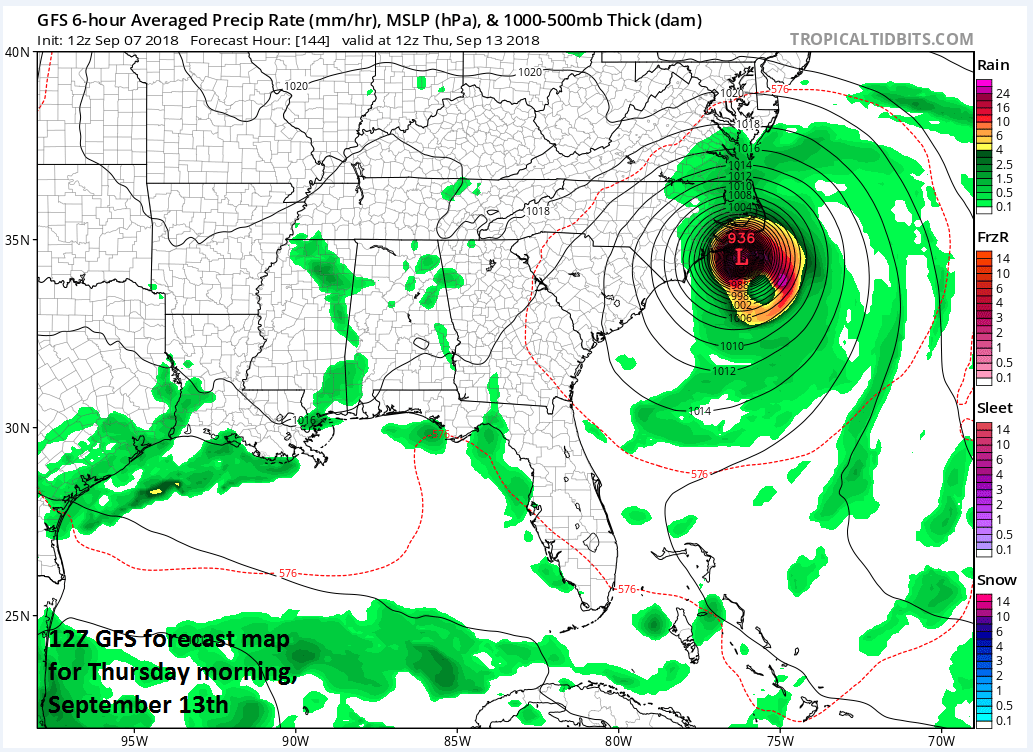
12Z GFS surface forecast map for Thursday morning, September 13th; courtesy NOAA/EMC, tropicaltidbits.com
Overview
Florence was downgraded in the overnight hours to “tropical storm” status, but it is quite likely to return to “major” hurricane status (i.e., category 3 or higher) in coming days. The evolving upper-level weather pattern will allow for Florence to head westward towards the US east coast over the next several days and it could have a significant impact during the latter part of the week. Meanwhile, Tropical Depression Gordon is currently drifting slowly to the north over Arkansas and it will combine with a strong cool frontal system to produce a wide swath of heavy rainfall through early next week extending from the south-central US to the Mid-Atlantic region. In addition, there are two other tropical systems in the eastern Atlantic that are very likely to intensify to hurricane level in coming days. The first of these trailing systems is likely to head on a “southern” track taking it towards the Caribbean Sea and there is a chance that the last system of the four will curve northward to the open Atlantic.

Total rainfall amounts over the next five days with a swath of significant rainfall from the south-central US to the Mid-Atlantic; courtesy NOAA/WPC
Gordon
With much of the (well justified) attention going to Tropical Storm Florence, the impact that the remains of Gordon may have over the next several days should not be ignored. In fact, significant rainfall is likely through early next week from the south-central US to the Mid-Atlantic region from the combination of Gordon and a frontal boundary zone and this is going to fall on already well-saturated grounds.
At 11am on Friday, Tropical Depression Gordon was drifting northward at 7 mph over the northern part of Arkansas. Gordon should continue drifting to the north over the next 12-24 hours and then take a turn to the northeast and accelerate from the south-central US towards the eastern Great Lakes. Meanwhile, a strong cool frontal boundary zone is currently stalling out across the southern Mid-Atlantic. As Gordon pushes to the eastern Great Lakes early next week, it’ll interact with the frontal system and pull it northward as a warm front. The combination of Gordon and the stalled out cool frontal system will result in a wide swath of heavy rainfall from the south-central US to the Mid-Atlantic region. Occasional showers are possible right through Monday with embedded thunderstorms possible and some of the rain can be heavy at times; especially, later Sunday into Monday when the front returns northward as a warm front. As strong high pressure builds over the next 24 hours into southeastern Canada and the Northeast US, our low-level winds will remain from an east-to-northeast direction and it’ll become noticeably cooler this weekend. In fact, both weekend days could have temperatures held to the lower 70’s or below for highs in the DC-to-Philly-to-NYC corridor.
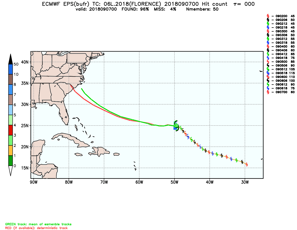
00Z Euro ensemble model "spread" of storm tracks forecasted for Tropical Storm Florence; courtesy NOAA/ECMWF
Florence
Tropical Storm Florence will head over warmer-than-normal water in coming days and is going to regain hurricane status this weekend and perhaps reach “major” hurricane status early next week over the western Atlantic. An upper-level trough of low pressure will swing by to the north of Florence this weekend and very likely not pull Florence to the north as earlier hoped.

Warmer-than-normal water in the Atlantic will favor intensification of Florence in coming days and play a role in the development of a strong ridge of high pressure across southeastern Canada and the northwest Atlantic; courtesy NOAA, tropicaltidbits.com
By early next week, the main feature in the upper atmosphere will be a very strong ridge of high pressure that will form over southeastern Canada and the northwestern Atlantic and it will open the door for Florence to head westward towards the US east coast. While still several days away, odds are increasing for Florence to reach the US east coast by the latter part of next week – perhaps initially into the Carolinas. Recent computer forecast model runs have tended to push Florence farther and farther to the west and this trend may continue as models tend to underdo the strength of upper-level high pressure ridging (to the north) from this far in advance of event time. In fact, if this trend continues, the ultimate path of Florence may be farther and farther inland after first making landfall somewhere along the east coast late next week.

The key player in the upper atmosphere in terms of the movement of Florence will be the anomalously strong high pressure ridge that sets up to the north early next week; courtesy NOAA/EMC, tropicaltidbits.com
Tropical systems 3 and 4
Another two tropical systems trail Florence in the eastern part of the Atlantic Ocean. The “frontrunner” of these two systems is likely to take a more “southern” route than Florence and head towards the Caribbean Sea. From there, this system could continue towards the Gulf of Mexico or even to the Southeast US. The final of the current four tropical systems is still near the west coast of Africa and there is hope that this one could curve to the north to the open Atlantic and never come close to land.

Tropical systems 3 and 4 in the eastern Atlantic will likely become hurricanes in coming days (named Helene and Isaac); courtesy NOAA/NHC
Stay tuned.
Meteorologist Paul Dorian
Perspecta, Inc.
perspectaweather.com
Extended video discussion on the remains of Tropical Depression Gordon and the continuing east coast threat from Tropical Storm Florence: