
2:30 PM | **Widespread cold later this week will have its coldest core over southern Canada, but the brunt of next week’s brutal cold air outbreak is headed right into the central and eastern US**
Paul Dorian
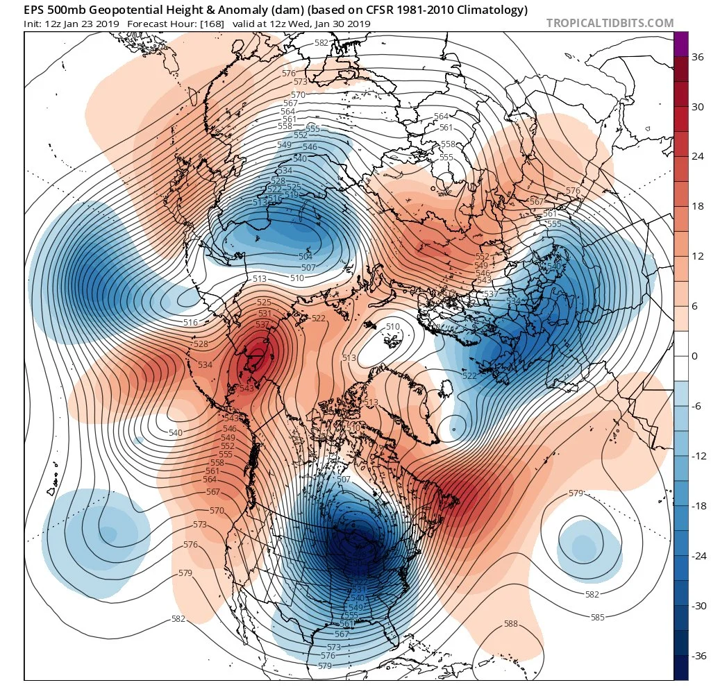
12Z EPS forecast map of 500 mb height anomalies by the middle of next week with a very deep upper-level low centered over the Great Lakes; courtesy ECMWF, tropicaltidbits.com
Overview
Despite the fact that it’ll turn unseasonably mild later tonight and early Thursday in much of the eastern US, the overall cold weather pattern shows no signs of slowing down. There will be another outbreak of cold air in the eastern US for the Thursday night/Friday/Saturday time period, but the coldest core of that air mass (relative-to-normal) will be centered over south-central and southeastern Canada. Next week, however, it looks like a brutally cold air mass will plunge southward right into the central US and eventually make its way to the east coast - and the coldest temperatures relative-to-normal will be in the US.

Brutal cold later this week will feature its coldest core (relative-to-normal) over the south-central and southeastern parts of Canada; courtesy NOAA, tropicaltidbits.com
Oh Canada
Low pressure is pushing northeast today over the Upper Midwest with significant snow on its north side (e.g., Wisconsin, Michigan) and rain to its south and east. This system will be over Quebec, Canada by early Thursday and will drag a strong cold front through the I-95 corridor and right to the western Atlantic. Temperatures are likely to drop from unseasonably mild levels early in the day (50’s) to the 30’s by day’s end in the DC-to-Philly-to-NYC corridor. It’ll be quite cold on Friday and Saturday in the Mid-Atlantic region despite plenty of sunshine as high pressure builds into the area. While temperatures here will be well below-normal on those days, the coldest core of this air mass will stay up to our north across southern Canada where they have had an incredible stretch of cold and snow.

Well below-normal temperatures last 7 days over Canada; courtesy Weather Bell Analytics, NOAA
Ottawa, for example, suffered its coldest snowstorm in more than 100 years earlier this week with temperatures around 10 degrees below zero as nearly a foot of snow piled up. [This is quite uncommon as the air is so dry at -10 degrees it is not easy to “squeeze out” a foot of snow]. In addition, the annual winter festival in Montreal was postponed this past weekend due to intense cold and snow. It’s the first time in a dozen years that weather interrupted the “Festival of Snow” in Montreal.

Brutal cold next week will feature its coldest core (relative-to-normal) over the Northern Plains/Upper Midwest/Great Lakes; courtesy NOAA, tropicaltidbits.com
Next week’s brutal cold
By the early part of next, the main piece of the polar vortex will drop southward to a position over the Great Lakes region and this will lead to another outbreak of bitter cold air. This time, however, the coldest core of the air mass will not be confined to southern Canada, but will head right into the central and eastern US and temperatures may drop to levels not seen in many years across the Northern Plains and Upper Midwest (watch out Chicago, Madison, Minneapolis!). This air mass will spread to the east coast by mid-week following the passage of a strong cold frontal system likely during the day on Tuesday.

12Z Euro 2-meter temperature anomalies look downright dangerous by Thursday of next week; map courtesy weathermodels.com (Dr. Ryan Maue), ECMWF