
10:45 AM (Tuesday) | ***Arctic blast has arrived in the eastern US…numerous record low temperatures by early Wednesday...watch for a brief changeover to snow in many spots***
Paul Dorian

Numerous record low temperatures were set this morning for the day and, in some cases, the all-time low temperature for November was recorded; map courtesy coolwx.com, NOAA
Overview
The strong cold front representing the leading edge of a widespread Arctic air mass passed through the DC-to-Philly-to-NYC corridor early this morning and temperatures have fallen into the 30’s from early day highs. Precipitation is being enhanced in the cold air behind the front as a strong jet streak aloft generates upward motion in the I-95 corridor. As a result, a changeover to snow is likely during the mid-day and early afternoon hours in the immediate DC-to-Philly-to-NYC corridor and this changeover to snow is likely all the way to coastal New Jersey and Delmarva. Some spots could receive small snow accumulations and as temperatures drop to near freezing later in the day, watch for the possibility of “black ice” on some roadways. Precipitation winds down later today and the cold will become the main story with record low temperatures in numerous Mid-Atlantic/NE US locations by early tomorrow. Widespread records were set earlier today from Texas to the Great Lakes with some stations recording their lowest temperature ever for the month of November and we are not even at the halfway point.
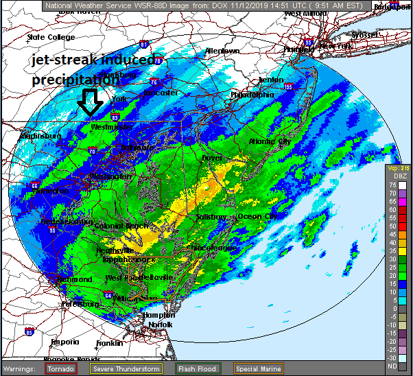
There is some post-frontal “jet-streak induced” precipitation (arrow) and this raises the chances for a changeover to snow from the immediate I-95 corridor all the way to the coastline; map courtesy NOAA
Details
Often times the passage of a frontal system signals the end of the precipitation, but that is not the case today as an upper-level jet streak is enhancing upward motion and helping to generate some post-frontal precipitation in the I-95 corridor. As temperatures continue to drop, the rain is changing over to snow in many locations and this changeover threat will extend all the way to the east coast over the next couple of hours. Small snow accumulations are possible and there is the possibility of some “black ice” to form on the roadways later today as temperatures slide towards the freezing mark.

An upper-level jet streak is helping to prolong the precipitation in the I-95 corridor as it helps to generate strong upward motion in the atmosphere; map courtesy NOAA, tropicaltidbits.com
A widespread region of the country experienced daily record or near record lows this morning and, in some cases, the lowest temperature ever recorded for the month of November took place which is particularly impressive since we haven’t even reached the mid-way point of the month. This area of record or near record lows will shift to the Mid-Atlantic/NE US by early tomorrow morning as many low temperature records are well within reach. For example, at Philly Int’l Airport (PHL), the record low for November 13th (Wednesday) is 24 degrees and this is certainly within reach and many suburban locations along the I-95 corridor will drop to the teens in the overnight hours. In addition to the potential for overnight low temperature records, high temperatures on Wednesday will be confined to the low-to-mid 30’s along the I-95 corridor and these may turn out to be the “lowest” high temperatures ever recorded for the date of November 13th.
This is one of the coldest starts to the month of November across the nation since the middle 1990’s. Map courtesy Weather Bell Analytics, NOAA
Some of the very impressive weather observations from this morning include monthly temperature records at Clinton, Oklahoma (12 degrees), Altus AFB, Oklahoma (13 degrees), Mt. Vernon, Illinois (10 degrees), and Fort Worth, Texas (20 degrees). This is especially impressive given the fact that we haven’t even reached mid-month and most monthly records are set near the end of the given month. In addition, the daily record set this morning at Indianapolis, Indiana of 8 degrees shatters the prior record set 108 years ago and Chicago, Illinois dropped to a record of 7 degrees - both are the lowest temperatures ever for so early in the season. In Detroit, Michigan, the Arctic blast resulted in nearly 10 inches of snow…the most ever there for the month of November. Finally, and not to be outdone, it dropped all the way down to 7 degrees in Amarillo, Texas earlier today.
Meteorologist Paul Dorian
Perspecta, Inc.
perspectaweather.com
Video discussion: