
11:00 AM (Sunday) | **Rain-to-accumulating snow scenario still on the table for the I-95 corridor late Tuesday night/Wednesday morning**
Paul Dorian

Upper-level energy (circled region) will enhance precipitation behind the cold frontal system early Wednesday; map courtesy NOAA; tropicaltidbits.com
Overview
A strong cold front will push across the Northern Plains and Upper Midwest on Monday and usher into these regions a bitter cold air mass for this time of year. This front will slow down in its advance to the south and east on Tuesday as it’ll become more aligned with an upper-level wind flow blowing front the southwest-to-northeast. At the same time, upper-level energy will be pushing along the southwestern portion of the front system in the Deep South and this is likely produce a wave of low pressure along the frontal boundary zone which could result in a rain-changing-to-accumulating snow scenario for the I-95 corridor from late Tuesday night into Wednesday morning.
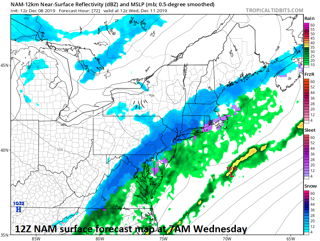
Surface forecast map for early Wednesday by the 12Z NAM features snow (in blue) in the I-95 corridor; map courtesy NOAA, trooicaltidbits.com
Discussion
Anytime a frontal system slows down in its advance to the south and east this time of year there is reason to worry as low pressure could form along the frontal boundary zone and precipitation can change from rain-to-snow as colder air filters into a given region. On Tuesday, a strong cold front will indeed be slowing down as it pushes to the southeast into the Great Lakes and Ohio Valley from the Northern Plains and upper-level energy is likely to be pushing into the south-central states. The upper-level energy in the south-central US on Tuesday may be just enough to form low pressure along the slowly-moving frontal boundary zone. Bitterly cold air will flood the Northern Plains and Upper Midwest by Tuesday with temperatures 20+ degrees below-normal for this time of year. As an example of the bitter cold, Minneapolis, MN may struggle to pass the 0 degree mark for highs on both Tuesday and Wednesday and wind chills can be -25 to -35 at midweek in that part of the country.

A bitter cold air mass reaches the Northern Plains, Upper Midwest early in the week and then the Mid-Atlantic region at mid-week; map courtesy NOAA, tropicaltidbits.com
Ahead of the front, temperatures in the DC-to-Philly-to-NYC corridor could actually climb towards the 60 degree mark for highs on Tuesday afternoon and there will be some rainfall, but temperatures will then drop Tuesday night with the arrival of the cold air mass. As low pressure develops along the frontal boundary and colder air arrives, the rain could change to accumulating snow late tomorrow night and continue into Wednesday morning and accumulations of a up to a few inches are certainly on the table for the DC-to-Philly-to-NYC corridor. Ultimately, the wave of low pressure that does form along the front will push to the northeast into New England and it is at this time that the flood gates will open and cold air will pour into the Mid-Atlantic region. Mid-week temperatures will be well below-normal in the Mid-Atlantic region with teens possible for lows on Thursday morning in many spots and overall conditions could be made even more harsh by a potential fresh snow cover - stay tuned on that.
Meteorologist Paul Dorian
Perspecta, Inc.
perspectaweather.com