2:55 PM (Monday) | *Another early spring night with below-freezing low temperatures…nor’easter forms on Tuesday and likely just skirts the Mid-Atlantic’s I-95 corridor*
Paul Dorian

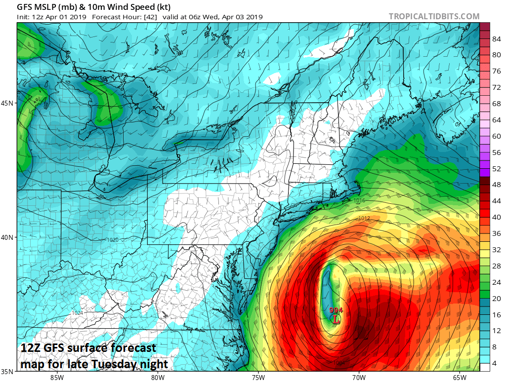
Strong low pressure will push to a position off the Mid-Atlantic coastline by later tomorrow night; courtesy NOAA/EMC, tropicaltidbits.com
Overview
After a spring tease on Saturday with temperatures in the 70’s, a strong cold frontal passage on Sunday ushered in a cold air mass for this time of year and it looks like another early spring night is coming to the DC-to-Philly-to-NYC corridor with low temperatures generally below-freezing. On Tuesday, low pressure will form and intensify along the Southeast US coastline and then it’ll make a push to the northeast tomorrow night and early Wednesday as a full-fledged nor’easter. The corridor between DC and NYC is likely to be spared the worst of the storm’s impact, but eastern New England could very well get hard hit with strong winds and some heavy precipitation.

Much colder-than-normal air will result in another early spring night with below-freezing low temperatures in much of the Mid-Atlantic region; courtesy NOAA, tropicaltidbits.com
Details
After another cold night for this time of year, skies may start off sunny on Tuesday morning, but clouds will increase during the afternoon hours as low pressure begins to form along the Southeast US coastline. This system will slip off the east coast and intensify tomorrow night into a strong nor’easter and will likely only skirt the region between DC and NYC. Showers are possible from later tomorrow into early Wednesday in the DC-to-Philly-to-NYC corridor and the winds may kick up for awhile tomorrow night, but there will be more impact in coastal sections of New Jersey and the Delmarva with somewhat higher rain totals and stronger wind gusts. By late tomorrow night and early Wednesday, this unfolding western Atlantic storm is liable to have a big impact on eastern New England (e.g., Cape Cod, MA) where strong winds and some heavy precipitation can take place – including the threat for accumulating snow. The ocean storm will pull away from New England on Wednesday and a return to sunshine here in the Mid-Atlantic region will result in milder conditions by later in the day.

A “negatively-tilted” trough axis (i.e., oriented from NW-to-SE) will help spawn a strong nor’easter late tomorrow that will likely skirt the Mid-Atlantic’s I-95 corridor, but it could impact more severely eastern New England; courtesy NOAA/EMC, tropicaltidbits.com
The next low pressure system to impact the Mid-Atlantic will first bring a warm front here on Thursday night and this will be followed by a cold front on Friday. As a result, rain showers are likely in the DC-to-Philly-to-NYC corridor on Thursday night and Friday with these two frontal systems and associated low pressure. In addition, there will be some cold air around in the Northeast US upon the arrival of the warm front which means snow showers are not out of the question in places like upstate Pennsylvania and just to the north and west of the NYC metro area. Once the late week system pushes away, it should turn milder during the weekend in the Mid-Atlantic region with the return of some early April sunshine. Looking ahead, there are likely to be a couple more cold shots coming this way from Canada as we progress through the next couple of weeks.
Meteorologist Paul Dorian
Perspecta, Inc.
perspectaweather.com
Video discussion: