10:10 AM | ***Severe thunderstorms, torrential rain a threat for later today, tonight and Thursday…excessive heat and humidity to peak Friday, Saturday and Sunday with a run to 100 degrees possible***
Paul Dorian
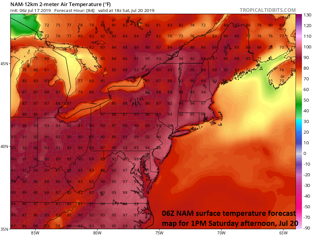
The forecast map of high temperatures on Saturday afternoon feature a large swath of mid-to-upper 90’s and 100 degrees is on the table in urban locations along I-95. courtesy NOAA, tropicaltidbits.com
Overview
There are two big weather stories unfolding for the Mid-Atlantic region for the next few days with the potential of severe thunderstorms and torrential rainfall later today and tonight as the remains of Barry pass through the region and then the hottest weather of the summer so far in the Friday through Sunday time frame. An already very warm and moist atmosphere will get even more unstable later today and tonight as a trough of low pressure associated with what was once tropical cyclone Barry passes through leading to numerous showers and thunderstorms.
Once this large tropical moisture field pushes away from the area, an atmospheric blow torch will setup and cause temperatures to soar on Friday in the I-95 corridor and it’ll stay excessively hot and humid this weekend with a run to 100 degrees possible during this stretch. There can be scattered showers and storms late Sunday with a weak frontal system and then more showers and storms on Monday associated with an even stronger frontal system which will usher in cooler air by next Tuesday. In fact, the remainder of July looks much more pleasant across the eastern half of the nation with normal-to-below normal temperatures and we could very well look back on this Friday-to-Sunday heat wave as the worst of the summer in the Mid-Atlantic region.
Strong-to-severe thunderstorms with torrential rainfall are likely later today/tonight in the Mid-Atlantic region as Barry’s remains pass through the area. The 06Z NAM model forecast map at 8pm features a line of storms in the I-95 corridor. Courtesy NOAA, tropicaltidbits.com
Severe thunderstorms and torrential rainfall
Low pressure associated with the remains of Barry will destabilize the atmosphere around here later today and this will lead to numerous showers and severe thunderstorms with torrential downpours and potential damaging winds. Given the already well saturated grounds, any heavy rainfall later today and tonight can result in flash flooding in the Mid-Atlantic region. Leftover moisture on Thursday will result in the threat for more showers and thunderstorms, but they are likely to be more of the scattered variety compared to the widespread rainfall expected later today and tonight. The most likely timetable for the showers and severe thunderstorms in the I-95 corridor will be from 4 pm to midnight. Temperatures today will reach well into the 90’s and the high (tropical) humidity will make it feel very oppressive – perhaps the worst day so far this season in many spots in terms of heat indices (i.e., combination of heat and humidity). There will be lots of clouds around on Thursday in the wake of Barry and this is likely to shave off a few degrees compared to today, but it’ll remain very humid and uncomfortable.
A major heat wave will grip the Midwest, Mid-Atlantic, and NE US over the next 5-days with a large area of above-normal 850 mb temperatures as depicted by the 06Z GEFS computer forecast model; courtesy NOAA, tropicaltidbits.com
Excessive heat Friday through Sunday
Once Barry’s tropical moisture field pushes away from here later tomorrow, the door will be open for very hot air to move into the Mid-Atlantic region from the west and southwest. As a result, temperatures should soar to the mid and upper 90’s for highs here on Friday and the excessive heat and humidity will persist this weekend and there can be a run to the 100 degree mark for afternoon highs. A weak front may produce scattered showers and thunderstorms late Sunday and more rain is likely later Monday with an even stronger frontal system.
A big change in the atmosphere will take place next week with an upper-level trough of low pressure forming over the eastern US and this will lead to a period of normal-to-below normal in the eastern half of the nation; courtesy NOAA, tropicaltidbits.com
Longer term relief
That stronger front will usher in a cooler air mass by the time we reach next Tuesday with highs likely confined to the 80’s. Looking ahead, the overall pattern is likely to evolve into one with an upper-level trough in the eastern US leading to normal-to-below normal temperatures for the remainder of the month of July. In fact, it is possible that we’ll look back at this Friday to Sunday stretch of excessive heat and humidity as the worst stretch of the summer.
Meteorologist Paul Dorian
Perspecta, Inc.
perspectaweather.com
Video discussion:


