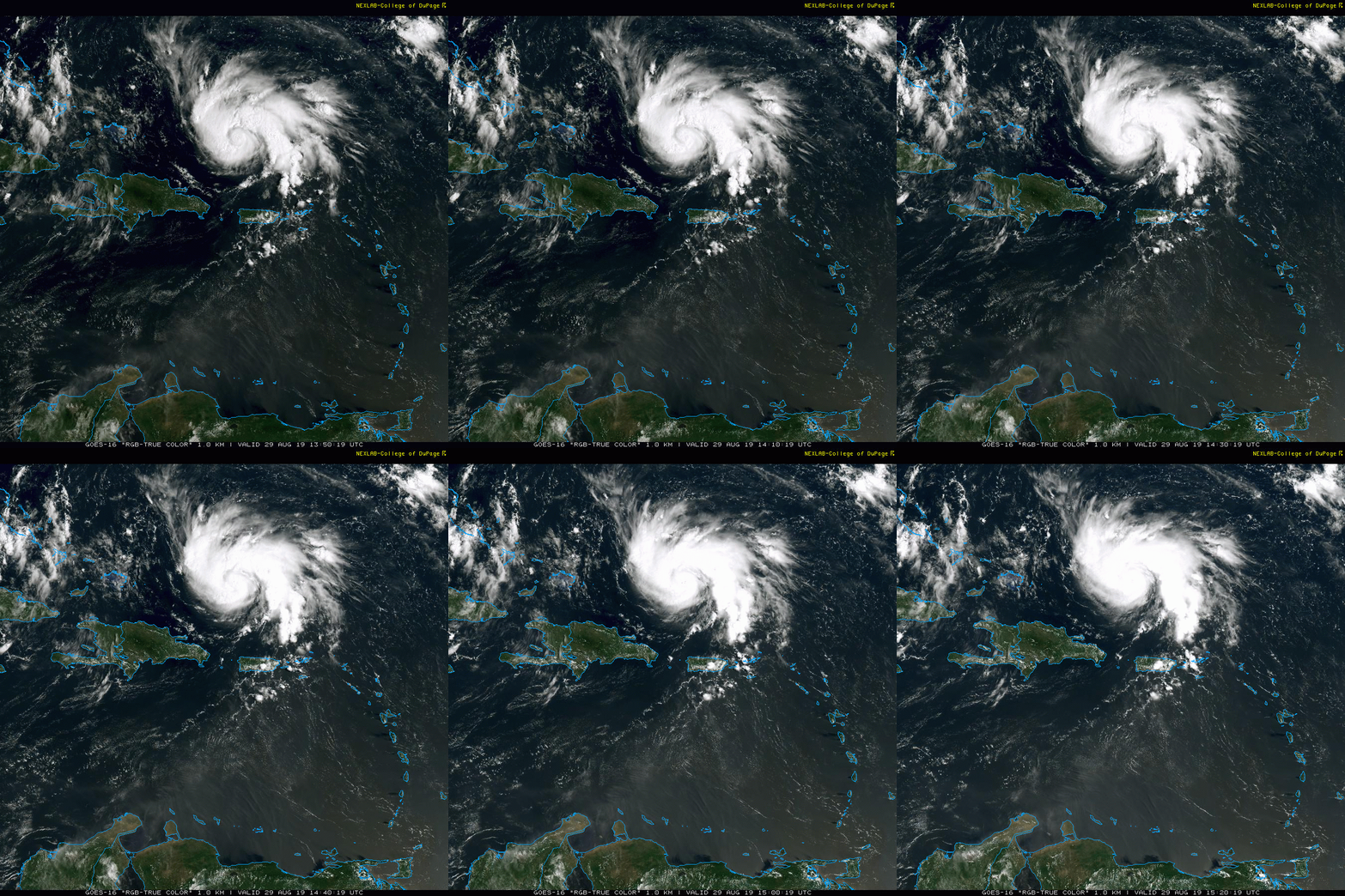
12:15 PM | ***Hurricane Dorian continues on a track towards the Bahamas and Florida...likely to become a “major” hurricane…residents in Georgia and the Carolinas need to stay on guard as well***
Paul Dorian
Hurricane Dorian has moved into the southwestern Atlantic where sea surface temperatures are quite warm for this time of year. There have been a few times during the past few hours where a small inner eye has appeared in the satellite imagery. Courtesy College of DuPage, NOAA
Overview
Hurricane Dorian continues to move to the northwest and is still categorized as a category 1 storm with max sustained winds at 85 mph. There have been intermittent signs of a small inner eye in satellite imagery during the past few hours. As atmospheric and oceanic conditions become more favorable over the next few days, Dorian is likely to strengthen into “major” hurricane status as it begins a shift from northwest-to-west with intensifying upper-level ridging to the north. On this track, Dorian would approach the east coast of Florida on Monday or Tuesday – likely as a “major” – but all residents from the Carolinas to Georgia have to stay on guard as a last minute turn to the northwest/north cannot be ruled out before it ever even reaches Florida.
Upper-level ridging will intensity over the western Atlantic Ocean over the next couple of days and this will result in an increasing westward flow of air that should shift Hurricane Dorian from a northwesterly direction to a westerly direction. By the latter part of the weekend, this upper-level ridging may weaken and pull to the east and this could result in a last minute shift to the northwest or north in the Sunday/Monday time frame and perhaps a slowing down of the storm. Courtesy NOAA, tropicaltidbits.com
Discussion
Hurricane Dorian is now out over the warm waters of the southwestern Atlantic and it has been relatively stable in terms of intensity during the past several hours although the central pressure has dropped a few millibars indicative of some minor strengthening. A key player in the ultimate strength and track of Hurricane will be the intensification of an upper-level ridge of high pressure over the western Atlantic. As this feature intensifies and spreads westward towards the east coast, atmospheric conditions will become more favorable for intensification. In addition, this ridge to the north will form a westerly flow of air on its southern flank and this will result in a subtle, but important shift in the track from northwest-to-west.
Often times when a tropical system makes a “bend” in this fashion significant intensification takes place. In the case of Hurricane Andrew (1992), it was during this “bending” phase that intensification became rapid and dramatic and it is certainly possible that the same type of scenario will occur with Hurricane Dorian (i.e, intensification to “major” status at the time of the “bend” in the track). As upper-level ridging intensifies in the general vicinity, there is usually divergence aloft with convergence in the lower levels and less wind shear and these favor strengthening. In addition, this is the time period in which Hurricane Dorian will be moving over very warm waters of the southwestern Atlantic.
GFS ensemble (left) and Euro ensemble (right) forecasted tracks of Hurricane Dorian bring it into east-central Florida and then shift it northward and ultimately northeastward. Courtesy NOAA, ECMWF
Numerous computer forecast models currently agree on movement of Hurricane Dorian into east-central Florida by later Sunday or Monday, but this is not yet a guarantee in my opinion. By the latter part of the weekend, signs point to a weakening of the all-important upper-level ridge and this could result in a last minute turn to the northwest or north as Hurricane Dorian arrives near the east coast of Florida raising the possibility of landfall up the coast in Georgia or the Carolinas. In addition, this potential weakening of the upper-level ridge at this particular time could also result in a slowing down of the storm by the late weekend or early part of next week.
The major intensification phase of Hurricane Andrew took place at the time of the “bend” (circled region) and this type of timing for strengthening may occur with Hurricane Dorian. Courtesy Wikipedia, NOAA
A look at “historical” storms that moved into the same general location as Hurricane Dorian currently exists suggests that this system may have trouble making it all the way west to the Florida Peninsula. More often than not, a tropical system in this particular location turned northwest or north just as it approached the east coast of Florida. If Hurricane Dorian does make landfall in Florida, it will be the fourth year in a row with a landfall in the state (Hermine 2016, category 1, Irma 2017, category 4, Michael 2018, category 5). The most consecutive years in Florida with landfalling hurricanes is 7 (1944-1950).
A historical look at tropical systems in the same general vicinity of Hurricane Dorian suggest it is difficult to make it all the way west to the Florida Peninsula. Courtesy NOAA, ESRI
Stay tuned…make preparations now for a potential “major” hurricane hit in Florida and pay very close attention if in Georgia or the Carolinas.
Meteorologist Paul Dorian
Perspecta, Inc.
perspectaweather.com
Video discussion:


