
9:30 AM | ****Hurricane Dorian regains “major” storm status…to significantly impact the coastal Carolinas next 24 hours…some impact in the Mid-Atlantic on Friday…tropical season far from over****
Paul Dorian

A broad look at Hurricane Dorian which has regained “major” hurricane status. Courtesy NOAA
Overview
Hurricane Dorian has regained some strength in the overnight hours and has been re-classified as a “major” category 3 storm with maximum sustained winds at 115 mph. It is moving slowly to the NNE at 8 mph and is currently just off the coast of South Carolina. There will be a major impact over the next 24 hours by Hurricane Dorian in the coastal Carolinas in places like Charleston, South Carolina and Wilmington and the Outer Banks in North Carolina. By mid-day Friday, Hurricane Dorian will be near the Outer Banks of North Carolina and it will become increasingly influenced by an advancing upper-level trough over the Great Lakes. As a result, Hurricane Dorian will accelerate to the northeast on Friday and pass well to the east of the Mid-Atlantic, but some impacts are likely that will in many ways resemble a “nor’easter” with the greatest impacts along coastal sections. Looking ahead, by no means does it look like the Atlantic Basin tropical season will slow down with the departure of Hurricane Dorian as numerous tropical waves are lining up over the continent of Africa.

A close-up view of Hurricane Dorian as it moves slowly near the South Carolina coastline. Courtesy NOAA, Penn State ewall
Discussion
Hurricane Dorian is to remain in an environment of light-to-moderate vertical wind shear and warm sea surface temperatures during the next 24 hours or so and this should result in either category 2 or 3 status as it pushes to the north and then northeast. Hurricane Dorian is moving NNE this morning just off the coastline of South Carolina and it will begin a turn to the northeast over the next 6-12 hours. This track will bring it very close to the South and North Carolina coastlines and then ultimately to a position right over the Outer Banks by midday Friday.
There is the chance that Hurricane Dorian makes landfall just inside the South and/or North Carolina coastlines, but even if no landfall is made, there will be a major impact in the region between Charleston, SC and the Outer Banks of NC including widespread power outages and some spots may experience worse flooding conditions than what took place a year ago with Hurricane Florence. In addition to the tremendous rain and wind in the coastal Carolinas, there have already been reports of numerous tornadoes and that threat will continue over the next 24 hours. Since 1950, 4 “major” hurricanes have made landfall in the Carolinas: Hazel (1954) - Cat. 4 - SC/NC border Gracie (1959) - Cat. 4 - SC Hugo (1989) - Cat. 4 - SC Fran (1996) - Cat. 3 - NC.

Hurricane Dorian regained some strength overnight in part due to a movement over warmer waters of the Gulf Stream and away from the “upwelling-induced” cool spot over the Bahamas that formed when the storm was nearly stationary in that region. Courtesy NOAA, tropicaltidbits.com
“Nor’easter-like” for the Mid-Atlantic on Friday
An upper-level trough of low pressure will cross the Great Lakes late tonight and Friday and this system will help to intensify a broader mid-latitude trough along the east coast. As a result, Dorian will accelerate to the northeast on Friday and pass well east of the Mid-Atlantic region and ultimately move to a position near Nova Scotia, Canada by the latter part of the weekend. However, despite the fact that the track of Hurricane Dorian will be well offshore, there can be important impacts from southeastern Virginia to the coastal sections of New Jersey and the Delmarva Peninsula.
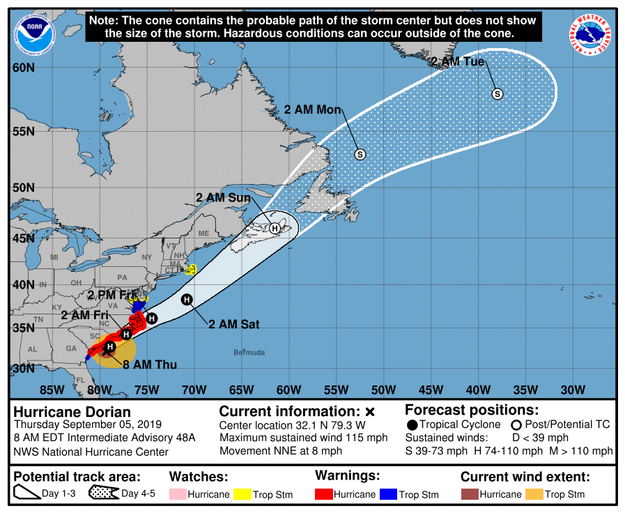
The latest “official” storm track for Hurricane Dorian as predicted by NOAA’s National Hurricane Center.
In many ways, this system will become similar to a “nor’easter” for the Mid-Atlantic region on Friday with the worst impacts along coastal sections where tropical storm force (northeast) winds of 40-50 mph are possible as well as some coastal flooding. The rain and wind can extend all the way back to the I-95 corridor as the rain and wind fields of what will become “post-tropical” Hurricane Dorian will actually expand to the northwest on Friday as a baroclinic zone develops (i.e., temperature gradient) between the warm air over the Gulf Stream and the much cooler air across interior the Mid-Atlantic. Much cooler air has pushed into the Mid-Atlantic region today following a cold frontal passage and it’ll remain quite cool on Friday as Hurricane Dorian slides to the east.
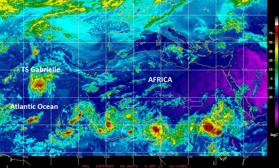
Tropical waves are lining up across Africa and there is no reason to believe the Atlantic Basin tropical season will quiet down with the departure of Hurricane Dorian later this weekend. Courtesy NOAA, CIMSS Wisconsin
Atlantic Basin tropical season far from over
Looking ahead, there is no reason to believe that Dorian will be the last of hurricanes in the 2019 Atlantic Basin tropical season. First of all, the typical season runs from about August 15th to October 15th so we have several weeks to go from a climatological point-of-view. In addition, numerous tropical waves can be seen in the latest satellite imagery over the African continent and they are all pushing to the west towards the tropical Atlantic Ocean riding along on tropical trade winds. With TS Fernand, TS Gabrielle and Hurricane Dorian in the Atlantic Basin at the same time as of a couple of days ago, this has become the 4th year in a row that we have had 3 or more named storms simultaneously during the hurricane season. Getting three named storms at the same time in the Atlantic Basin is a fairly common occurrence as it has about 52% of the time in the satellite era (since 1966; source Philip Klotzbach, CSU). Looking at the line-up of tropical waves currently over the continent of Africa, there is no reason to believe that the active weather pattern will change in coming weeks.
Meteorologist Paul Dorian
Perspecta, Inc.
perspectaweather.com
Video discussion: