
11:55 AM (Tuesday) | *Monitoring weekend storm threat…odds currently favor predominately rain in the DC-to-Philly-to-NYC corridor*
Paul Dorian
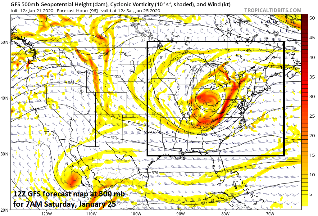
An important player in the upcoming weekend event for the Mid-Atlantic/NE US will be this wave of energy in the upper atmosphere. Its ultimate placement will have an impact on precipitation type in places like the I-95 corridor from DC-to-Boston. Map courtesy NOAA, tropicaltidbits.com
Overview
A strong wave of energy in the upper part of the atmosphere will drop into the Ohio Valley by the early part of the weekend and it’ll play an important role in the likelihood of rain and snow in the Mid-Atlantic/NE US. Initially, a wave of low pressure at the surface will push into the Ohio Valley, but ultimately, a secondary system should form near the Mid-Atlantic coastline. Odds currently favor rain in the I-95 corridor from DC-to-Philly-to-NYC, but a small change in the positioning of the upper level low to the south and east could result in a slightly colder solution for the big cities.

12Z GFS surface forecast map for Saturday evening with rain (green) in the immediate I-95 corridor and snow (blue) in some interior locations of the NE US; map courtesy NOAA, tropicaltidbits.com
Details
The next few days will continue to be dominated by strong high pressure now centered over the middle of the country which has brought some of the coldest air so far this season all the way down to Florida. Temperatures this morning bottomed out in the low-to-mid teens in many suburban locations along the I-95 corridor in the Mid-Atlantic and fell way down into the low-to-mid 40’s as far south as central Florida. Tonight’s actual temperatures could bottom out around 43 or 44 degrees as far south as Miami, FL with wind chills in the 20’s and 30’s - the coldest weather experienced down there in a couple of years. This high pressure system will weaken as it shifts to the eastern seaboard by the latter part of the week and this keep us dry and chilly through Friday.

12Z GFS surface forecast map for Sunday morning with snow (blue) in many interior locations of the NE US; map courtesy NOAA, tropicaltidbits.com
Attention will then turn low pressure that will form over the Ohio Valley by Friday night aided by strong upper-level energy. A secondary low will then form over the Appalachians by early Saturday and ultimately will become the main system as it intensifies near the Mid-Atlantic coastline this weekend. Then exact location of the key upper-level wave of energy is still in some doubt as is the strength and location of the secondary low that will form near the coastline. The timing and placement of these features will have an impact on precipitation type in the Mid-Atlantic region in the Friday night-Saturday night time period.
Currently, odds favor rain in the immediate I-95 corridor with snow likely in interior locations from upstate PA-to-New York State-to-New England. In fact, significant snow can fall with this weekend system in some of these interior locations from New York State to northern New England. As the low pushes off to the northeast late Saturday or early Sunday, there can be an intrusion of colder air which could cause a changeover from rain-to-snow in some areas close to Route I-95 and perhaps to the coastline. Stay tuned, there are still a few days to go before the weekend event and time for some changes in the overall setup.
Meteorologist Paul Dorian
Perspecta, Inc.
perspectaweather.com
Follow us on Facebook, Twitter, YouTube
Video discussion: