10:40 AM (Tuesday) | ***Accumulating snow now closing in on the DC metro region…reaches Philly in the mid-to-late afternoon hours...snow squalls on Wednesday***
Paul Dorian

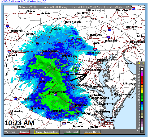
An impressive band of precipitation is heading towards the DC metro region. The precipitation should start in the DC metro region between about noon and 2 PM and it can start as a mix of rain and snow. However, given the quite cold air in the lower and middle atmosphere, any mixed precipitation at the onset should change rather quickly to all snow in the northern and western suburbs…it may hold on as a mix for a bit longer in the District. Precipitation reaches the Philly metro region during the mid-to-late afternoon hours. The snow is likely to come down quite hard at times so watch for slick spots on the roadways. Map courtesy NOAA
Overview
Low pressure is intensifying at this hour as it takes a path from the Tennessee Valley to the coastal waters of New Jersey and it will produce accumulating all along the I-95 corridor. Snow is closing in on the DC metro region and it should reach the Philly area during the mid-to-late afternoon hours and then into NYC by early tonight. While there can be rain mixed in at times in the initial stages of this event, the bulk of the precipitation in the DC-to-Philly-to-NYC corridor should be in the form of snow. General accumulations of 1-3 inches are expected from DC-to-Philly with isolated 4 inch amounts possible…slightly lesser snowfall totals are expected in NYC and Boston. Watch for slick road conditions this afternoon and tonight as the snow is likely to come down quite hard at times. In the wake of the storm, it’ll be cold and windy on Wednesday with gusts past 40 mph and snow showers and squalls are quite likely in much of the Mid-Atlantic region. The cold air mass that arrives in the wake of the storm will give way to a big warm up this weekend with the 60’s possible in the I-95 corridor.

A vigorous wave of energy in the upper atmosphere will help to intensify surface low pressure as it treks from the Tennessee Valley to the coastal waters of New Jersey by early tonight. Map courtesy NOAA, tropicaltidbits.com
Details
Low pressure system developed over the Tennessee Valley early today and it is intensifying at this hour as upper-level energy moves overhead. This system will trek to the coastal waters of southern New Jersey by early tonight and then will scoot off to the east-northeast of there in the overnight hours. The region from DC-to-Philly is in store for a general 1-3” snowfall and there can be isolated 4” totals in some spots; especially, to the west of the metro areas. With the movement of the surface low pressure system off to the east-northeast from the New Jersey coastal waters instead of up along the NE coastline, there will be somewhat less of an impact in NYC and Boston. The snow will likely last through much of the evening hours in southeastern PA and across southern/central New Jersey as moisture “wraps around” the intensifying low pressure system into its northwest sector. Temperatures will be marginal at the surface during the onset of this event so rain can be mixed in at times initially, but the bulk of the precipitation should be in the form of snow given the quite cold conditions in the lower and middle levels of the atmosphere.

“Wrap-around” moisture will extend the snow this evening across SE PA and much of New Jersey as low pressure continues to intensify just off the New Jersey coastline. Map courtesy NOAA, tropicaltidbits.com
Another cold air mass will follow the low pressure system on Wednesday with strong NW winds reaching 40+ mph and there can be snow showers across the Mid-Atlantic region; especially, to the north of the PA/MD border and we’ll have to watch for possible heavier snow squalls as well. Any snow squall on Wednesday can reduce visibilities in a hurry, create slick driving conditions, and cause small additional accumulations.

Wednesday will be a windy, cold day in the wake of today’s storm and there are likely to be snow showers and snow squalls scattered about the Mid-Atlantic/NE US. Map courtesy NOAA
As high pressure moves overhead late tomorrow night and Thursday, the winds will die down, but it remains cold. However, a sharp warm up will take place by the weekend as that same high pressure shifts off the east coast. In fact, temperatures could reach the 60’s on Saturday – just ahead of the next storm system – and more rain is likely to fall in the Mid-Atlantic region.

Snow depth change for this upcoming event as depicted by the 12Z NAM (12-km version). Map courtesy NOAA, tropicaltidbits.com
Meteorologist Paul Dorian
Perspecta, Inc.
perspectaweather.com
Video discussion: