12:15 PM (Friday) | *Arctic blast to send accumulating snow all the way down to Texas/New Mexico with numerous record low temperatures…tropical wave likely to head towards the southern Gulf of Mexico*
Paul Dorian

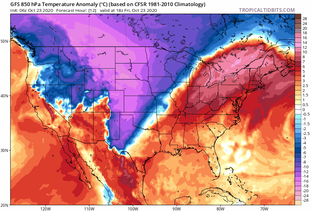
Unusually intense Arctic air for this time of year will spread from the northern Rockies to the southwest US and southern Plains in coming days and it will accompanied by accumulating snow. Maps courtesy NOAA, tropicaltidbits.com
Overview
It has already been quite cold for this time of year across much of the interior Northwest and Northern Plains with significant accumulating snow in many areas in recent days and the worse may be yet to come. An Arctic blast will send temperatures plunging over the next few days all the way down to the southwestern US and southern Plains and accumulating snow can fall all the way down to states like Texas and New Mexico. In addition, numerous record low temperatures are likely to fall from the Northern Rockies to the southern Plains during this unusual late October cold wave. Meanwhile, in the tropics, Hurricane “Epsilon” will turn to the northeast and accelerate this weekend out over the open waters of the North Atlantic. Another tropical system will intensify over the northwest Caribbean Sea – likely reaching tropical storm status this weekend – and then it could head towards the central Gulf coastal region by the middle of next week.

Total snowfall over the next five days will feature accumulations from the northern US all the way down to Texas and New Mexico. Map courtesy NOAA, tropicaltidbits.com
Arctic blast and accumulating snow
It was just last weekend that unusual early season cold and snow gripped the Northern Rockies and places like Great Fall, Montana had their snowiest October day ever with accumulations of more than 8 inches. That same winter storm pushed to the east and dumped significant and unusual early season snow on places like Minneapolis, Minnesota and this same region will receive more snow in coming days. In fact, Minneapolis reported 7.9 inches of snow on Tuesday which was the highest amount ever for so early in the season and it just missed out on being the most snow ever on an October day (8.2 inches on 10/31/1991). This next shot of snowfall this weekend could feature as much as 6-12 inches of snow from Montana to parts of the Dakotas and Minnesota.
This Arctic blast will be quite impressive in terms of temperatures and even more extreme relative-to-normal than the one experienced in early September. Temperatures could drop to as much as 30+ degrees below-normal for late October from the northern Rockies to the southern Plains with numerous record lows likely to be set. In fact, there may be many spots in Idaho, Montana and Wyoming, for example, that will feature temperatures close to zero in this unusual early season cold wave and low temperature records could be shattered by as much as 20 degrees in some spots. The all-time low for the month of October in Missoula, Montana is right at zero degrees set in 1971 and the low temperature expected there on Saturday night should be awfully close to that figure.

Hurricane “Epsilon” can be seen over the central Atlantic (far right) and a better organized tropical wave is visible over the Caribbean Sea (circled region). Image courtesy NOAA/NESDIS
Tropical activity hangs on
As the cold and snow grips part of the western and central US, the Atlantic Basin remains active in terms of late season tropical activity. Hurricane “Epsilon” is now located to the northeast of Bermuda with maximum sustained winds of 85 mph. It is pushing to the north at last reading and will accelerate to the northeast this weekend farther out into the open waters of the North Atlantic. Elsewhere, a strong tropical wave has become better organized over the northwestern Caribbean Sea. In fact, it is possible that this wave becomes an officially-designated tropical storm this weekend as it moves to the northwest over still relatively warm waters of the Caribbean Sea. By the early part of next week, this system will likely cross over or come close to the Yucatan Peninsula region of Mexico and then it may spill out over the southern Gulf of Mexico.
Meteorologist Paul Dorian
Perspecta, Inc.
perspectaweather.com
Follow us on Facebook, Twitter, YouTube