
12:30 PM (Tues) | *Astonishing cold and unusual early season snow…”Zeta” to make landfall later Wed. in SE LA…significant rain event for TN Valley/Mid-Atlantic…snow in the NE US and a cold Halloween*
Paul Dorian

Temperatures were 30-50 degrees below-normal late yesterday in a widespread area from the Dakotas to Texas and west to the Rockies. Map courtesy weathermodels.com, NOAA
Overview
While the Atlantic Basin tropical scene remains active, an Arctic blast continues to bring record-breaking cold to portions of the western and central US as well as some unusual early season accumulating snow and ice. Meanwhile, Tropical Storm “Zeta” is now entering the Gulf of Mexico after a brief encounter with the Yucatan Peninsula region of Mexico and it is quite likely to return to hurricane status (category 1) later today and then make a landfall later tomorrow in southeastern Louisiana. The remnants of “Zeta” will combine with a strong upper-level low now over the Southwest US to generate a significant rain event in the Tennessee Valley, Mid-Atlantic region and Northeast US from Thursday into early Friday. On Friday, enough cold air will get wrapped into the powerful system to cause a changeover to snow to result in the first accumulating snows of the season for portions of the Northeast US. All of this will be followed by a cold Halloween on Saturday with temperatures some fifteen degrees below-normal in the Mid-Atlantic/Northeast US.
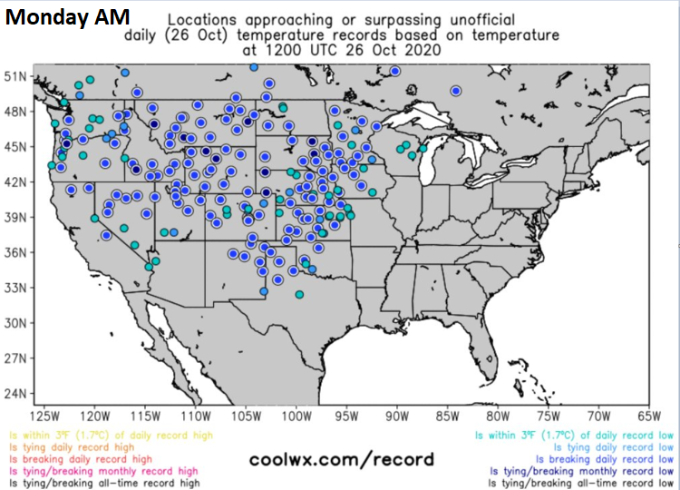
Numerous record or near record low temperatures on Monday, October 26th across the central and western US. In many spots, the lowest temperature ever recorded for the month of October was observed. Map courtesy coolwx.com, NOAA
Some amazing cold and unusual accumulating snow
The Arctic cold has been historic in recent days across portions of the western and central US with some long-standing low temperature records being absolutely annihilated. In fact, temperatures late Monday were running as much as 30-50 degrees below normal in a widespread area stretching from the Dakotas to Texas as well to the west across the Rockies.

Numerous record or near record low temperatures on Tuesday, October 27th across the central and western US. In many spots, the lowest temperature ever recorded for the month of October was observed. Map courtesy coolwx.com, NOAA
One example of the extreme cold took place in Denver, Colorado on Monday where the high temperature topped out at 15°F. This was not only the coldest high temperature ever recorded in Denver during the month of October, it completely shattered the previous daily record for October 26 by halving the comparatively “balmy” 31°F that was set in 1923. The records in Denver go all the way to 1872 (i.e., 142 years) and the prior coldest high temperature in October was 18°F. The low temperature in Denver this morning was a record-breaking 8°F. Another example of the extreme cold occurred in Bozeman, Montana where earlier today the low temperature recorded was -20°F, which is 31 degrees below the previous record of +11°F. Finally, the astonishing cold in the Rockies featured a low temperature earlier today of -26°F in Laramie, Wyoming which, if verified, would not only break the monthly record for the month of October by 8 degrees, it would tie the coldest temperature for any day in November.
In terms of snow, accumulations will be significant over the next 36 hours or so in parts of New Mexico and Texas with more than half a foot in some spots on top of what has already been received. In addition, ice will be a major problem in some parts of the southern/central Plains over the next 12-24 hours (e.g., Oklahoma). Yesterday, as much as a foot and a half of snow was observed in some parts of the Colorado Rockies. Earlier in this extended cold spell, there was impressive accumulating snow in an area extending from the interior Northwest to the Northern Plains. For example, Great Falls, Montana experienced its snowiest “one-day” ever in the month of October and also its greatest “two-day” snowfall total ever. In Alexandria, Minnesota, the snowfall this month has already made it the most ever for the month of October.

Tropical Storm “Zeta” is likely to make landfall late tomorrow in the southeastern part of Louisiana - perhaps as a category 1 hurricane. Map courtesy NOAA/NHC
Tropical Storm “Zeta”…significant rain event…accumulating snow threat on Friday in the Northeast US
While the western and central US experience unusual cold and snow, the Atlantic Basin is still featuring tropical activity. “Zeta” is now classified as a tropical storm after it weakened slightly in the overnight hours while encountering the northeastern part of Mexico’s Yucatan Peninsula. This tropical system is now entering the Gulf of Mexico and will likely return to category 1 hurricane status later today as it moves over the still relatively warm waters. By later tomorrow, “Zeta” will likely make landfall in the southeastern part of Louisiana – probably as a category 1 hurricane. This will make the 5th direct hit of the tropical season in the state of Louisiana and “Zeta” has put 2020 into the record books by matching the 2005 season for the highest number of named storms in a given year. While the number of named storms may now be equal, the strength of the storms in 2005 was on average notably higher than this year. Of the 27 named storms so far in 2020, only four have reached major hurricane status (i.e., category 3 or higher) whereas in 2005, there were seven majors, also a record.

A significant rain event is coming to the Tennessee Valley, Mid-Atlantic and Northeast US from Thursday into Friday with the combination of the remains of “Zeta” and a strong upper-level low. Map courtesy NOAA/WPC
After landfall, the remains of “Zeta” will turn northeast and combine with a strong upper-level low now over the Southwest US to generate a powerful storm system and a significant rain event across the Tennessee Valley, Mid-Atlantic region and Northeast US from Thursday into Friday. By late Thursday night and early Friday morning, this powerful storm will likely be situated off the Mid-Atlantic coastline and a cold air mass will begin to get wrapped in. As a result, there is a good chance that some of the higher elevation, interior sections of the Northeast US (e.g., Poconos, Catskills, Hudson Valley) experience a changeover from rain to snow with accumulations certainly on the table. In fact, there can be accumulating snow all the way down to the coastline of southern New England and flakes are possible as far south and east as New York City.

Accumulating snow is indeed a possibility on Friday in portions of the Northeast US as depicted here from the 06Z Euro model forecast. Map courtesy Weather Bell Analytics, ECMWF
First freeze possible and a cold Halloween in the Mid-Atlantic/Northeast US
Following the departure of the storm, it’ll turn quite cold on Friday night in the Mid-Atlantic and Northeast US with the first below-freezing low temperatures possible – even in the DC-to-Philly-New York City corridor. If, in fact, Saturday does bring the first freeze of the season, it’ll mark the shortest growing season in some areas (e.g., Chester County, PA: source Paul Callahan, Twitter) since 2002 at 174 days between freezes. On Saturday, temperatures could very well average out to be some fifteen degrees below-normal in the Mid-Atlantic/Northeast US making for quite a cold time of it for trick-or-treaters as we end the month of October. In fact, temperatures could actually dip into the single digits across the southern tier of New York State by early Saturday where there could be a decent snowfall on the ground.
One final note, this is the weekend to turn the clocks back as of early Sunday morning, November 1st.
Meteorologist Paul Dorian
Perspecta, Inc.
perspectaweather.com
Follow us on Facebook, Twitter, YouTube
Video discussion: