
12:45 PM (Wed) | *Zeta makes landfall later today…major rain event for the southern/eastern US…much colder on Friday with snow in parts of the NE US…first freeze of the season*
Paul Dorian
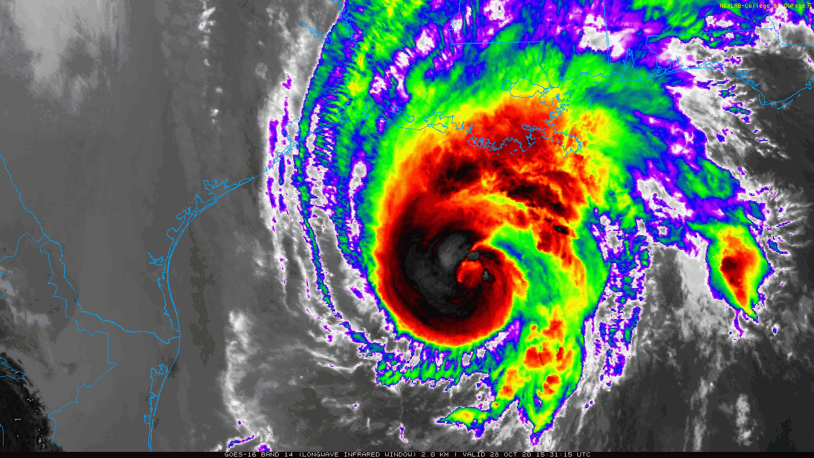
Hurricane Zeta is pushing fairly rapidly towards an afternoon landfall in the southeastern part of Louisiana. Images courtesy College of DuPage, NOAA
Overview
Hurricane Zeta is headed for a landfall later today in the southeastern part of Louisiana - perhaps as a category 2 storm - and this will make the 5th direct hit this tropical season in that particular state. After landfall, Zeta will combine with an upper-level low to generate a wide swath of heavy rain from the Gulf coastal region to the southern part of New England. By late tomorrow night, much colder air will begin to get wrapped into this powerful storm system as it exits off the Mid-Atlantic coastline. The result is likely to be a changeover to snow on Friday in some of the interior, higher-elevation locations of the Northeast US and accumulations are certainly on the table in some of these areas. The first hard freeze of the season is likely to follow on Friday night/early Saturday in much of the Mid-Atlantic region and Northeast US and a cold Halloween will follow on Saturday. Yet another impressive cold air outbreak will arrive in the Mid-Atlantic/Northeast US by early next week and there can be “lake effect” type snows in the Great Lakes - perhaps even snow showers reaching the I-95 corridor later Monday.

00Z Euro forecast map for Thursday afternoon depicts heavy rainfall from the Tennessee Valley to the Mid-Atlantic region. Map courtesy WSI, Inc., ECMWF
Zeta…significant rain event…cold/snow threat/first freeze of the season
As of 11AM, Hurricane Zeta was moving north at 18 mph with maximum sustained winds at 90 mph and is likely headed for an afternoon landfall in southeastern Louisiana. There is a decent chance that Zeta intensifies enough to attain category 2 status (96+ mph winds) before landfall later in the day. The fairly rapid movement is a bit of good news for the hard hit state of Louisiana as it will reduce somewhat the amount of time the state gets hit with damaging winds and torrential rains. The east side of the storm system will be the worst in terms of the storm surge and damaging winds with gusts likely at 100+ mph. Zeta will accelerate tonight and on Thursday resulting in significant rain making it all the way into the Mid-Atlantic region and southern part of New England by mid-day or early afternoon. Heavy rain will continue on Thursday night in these same areas at the same time colder air gets wrapped into the powerful system which should be exiting off the Mid-Atlantic coastline at that time.

The first hard freeze of the season is coming to much of the Mid-Atlantic/Northeast US late Friday night/early Saturday. Another impressive cold blast arrives on Sunday night/Monday in these same areas. Map courtesy NOAA, tropicaltidbits.com
On Friday, enough cold air will push into the Northeast US for a changeover from rain to snow; especially, in the interior, higher elevation locations from the Poconos (PA) to the Catskills (NY) to the Hudson Valley (NY). Some snow accumulations are possible on Friday in these areas and all the way down to the coastline of southern New England. The entire mess pushes off the east coast by late Friday and high pressure will push quickly into the Northeast US during the overnight hours of Saturday. This will set the stage for the first widespread freeze of the season by early Saturday morning in much of the Mid-Atlantic/Northeast US - even in the urban corridor along Route I-95. Halloween Day will feature temperatures as much as fifteen degrees below-normal and a cold time for trick-or-treaters.

Another cold blast will arrive in the Mid-Atlantic/Northeast US by early next week and this will contribute to “lake effect” type snow in the Great Lakes. Map courtesy NOAA, tropicaltidbits.com
Another cold shot early next week
If a freeze does not take place on Friday night/early Saturday, there will another opportunity early next week in the Mid-Atlantic/Northeast US as an even colder air mass pushes across the Great Lakes. Windy and cold conditions are likely on Monday and temperatures could drop once again to freezing or below late Monday night/early Tuesday in the Mid-Atlantic/Northeast US. This outbreak of cold air early next week may result in the first widespread “lake effect” types snows across the Great Lakes - perhaps even snow showers reaching the I-95 corridor later Monday.
Meteorologist Paul Dorian
Perspecta, Inc.
perspectaweather.com
Follow us on Facebook, Twitter, YouTube
Video discussion: