12:30 PM (Tues.) | *Hurricane Eta inches closer to Nicaragua…to pound Central America with tremendous rainfall amounts…threat from Eta likely shifts to Cuba, southern Florida later this weekend*
Paul Dorian

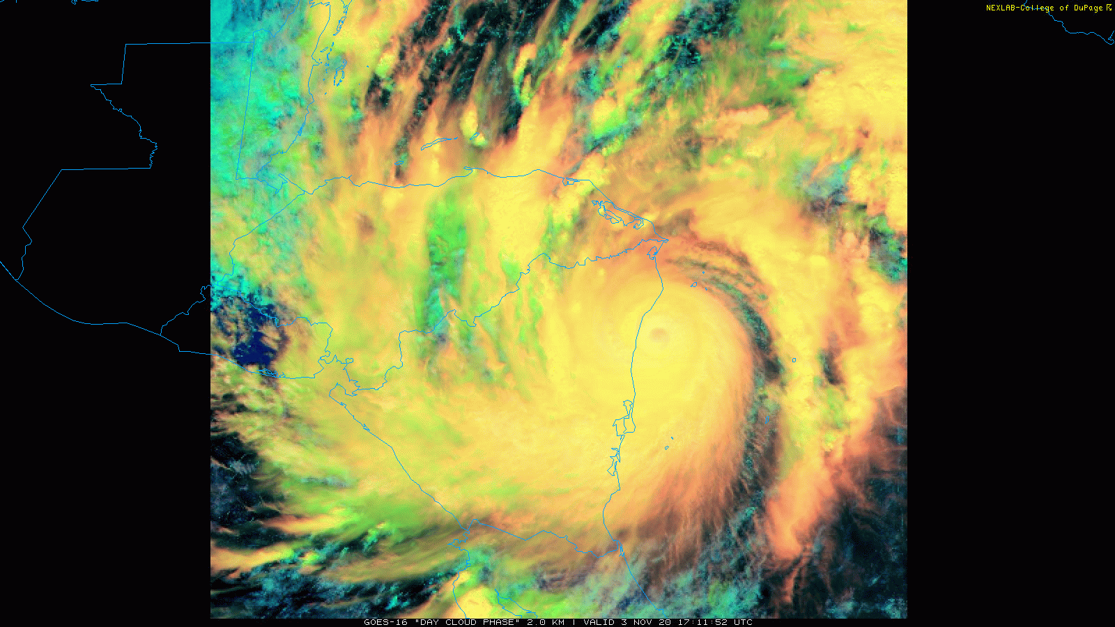
Hurricane Eta is about to make landfall in northeastern Nicaragua as a category 4 storm. Images courtesy NOAA, College of DuPage
Overview
Eta is a “major” hurricane and is edging its way to the northeastern coastline of Nicaragua in Central America. The extreme strength of Hurricane Eta combined with its very slow movement is bad news as it will likely result in catastrophic wind damage, tremendous rainfall amounts of up to three feet in some spots, and landslides in some of the higher terrain sections of Central America. After landfall in northeastern Nicaragua later today, Hurricane Eta will inch slowly westward over the next couple of days and push over Honduras on Thursday. Later in the week, a developing trough over the northern Gulf of Mexico should cause Eta (or its remnants) to turn northward and then to the northeast. This change in course will likely result in a re-strengthening of Eta as it pushes back out over the open waters of the western Caribbean Sea by the early part of the weekend and then the threat from this tropical system will perhaps shift to Cuba and southern Florida by the latter part of the weekend or early part of next week.

High pressure will build into the Northeast US/Southeast Canada in coming days and this often results in tropical troubles to its south of the ridge in the Gulf of Mexico/SW Atlantic. Map courtesy NOAA, tropicaltidbits.com
Details
Hurricane Eta - the 28th named storm of the Atlantic Basin tropical season - has intensified into a strong category 4 storm with maximum sustained winds of 145 mph. Its movement at 11 AM was only 4 mph in a west-southwest direction. Hurricane Eta deepened significantly during the last 48 hours with its central pressure plunging from 1005 to 923 millibars – a drop of 82 millibars. There have been only three other storms on record in the Atlantic Basin that have deepened that significantly in a two-day period: Andrew (1992), Rita (2005) and Wilma (2005).
Hurricane Eta is now on the doorstep of Nicaragua’s northeast coastline and will likely not be able to attain category 5 status. Nonetheless, the extreme strength of Eta combined with its very slow movement will likely result in up to three feet of rain over the next few days from Nicaragua to Honduras – despite weakening along the way. There have been three category 4 hurricanes in the Atlantic Basin during the month of November listed as follows: Lenny (1999), Michelle (2001) and Paloma (2008).

Hurricane Eta will have a major impact on the Central America countries of Nicaragua and Honduras over the next few days. Map courtesy NOAA/NHC
After Hurricane Eta impacts Nicaragua and Honduras, it is likely to turn to the north and then northeast and move over or near Belize on its way back to the open warm waters of the western Caribbean by the end of the week. The upper-level pattern that is unfolding in coming days will feature strong high pressure ridging over the Northeast US and southeastern part of Canada and this will allow for the remains of Hurricane Eta to push northwards by the latter part of the weekend. As such, the threat from Eta will increase in Cuba and southern Florida and this same system may meander around for several days. In fact, there are some signs that we may not only be monitoring Eta in a week, but perhaps as long as two weeks or so into the future.
Meteorologist Paul Dorian
Perspecta, Inc.
perspectaweather.com
Follow us on Facebook, Twitter, YouTube
Video discussion: