11:30 AM | **Wild weather pattern to include some freezing rain, heavy rainfall/flash flooding, and even the possibility of accumulating snow this weekend**
Paul Dorian
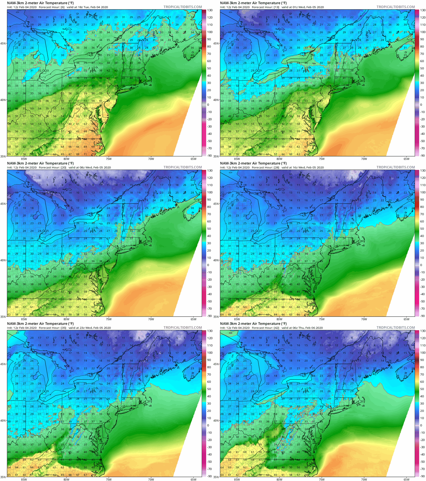
Temperatures will drop noticeably between late today and Wednesday morning following the overnight passage of a southward-moving cold frontal system; maps extend from 1PM Tuesday to 1AM Thursday, courtesy NOAA, tropicaltidbits,com
Overview
An active weather pattern will produce a freezing rain threat in the Mid-Atlantic region from later tomorrow into early Thursday, a heavy rain and flash flooding threat from Thursday night into early Friday, and then perhaps some accumulating snow from Saturday night into Sunday. A strong cold frontal passage in the overnight hours will result in a dramatic drop in temperatures from this afternoon’s well above normal levels to more winter-like conditions on Wednesday and Wednesday night. The same front will then push back to the north as a warm front late Thursday and pave the way for a strong low pressure system to generate some heavy rainfall around here from Thursday night into early Friday. Yet another low pressure system could generate some accumulating snow in the Mid-Atlantic region during the upcoming weekend.
A colder air mass will follow the passage of s southward-moving cold front and this will lead to some freezing rain (pink) in the Mid-Atlantic region from later tomorrow into early Thursday; map courtesy NOAA, tropicaltidbits.com
Details
Multiple low pressure systems will impact the Mid-Atlantic region in coming days with the possibility of freezing rain, heavy rainfall/flash flooding, and even accumulating snow. Yesterday’s very mild weather for early February is being followed up with another warmer-than-normal day, but a southward-moving cold front will flip temperatures quite noticeably between late today and early tomorrow. In fact, temperatures are likely to drop from the 50’s and 60’s on Tuesday afternoon to the 30’s by early tomorrow in the DC-to-Philly-to-NYC corridor and this change in air mass could lead to a period of freezing rain from later tomorrow into early Thursday. The best chance for freezing rain will extend from the northern and western suburbs of DC to inland areas north of the PA/MD border.
A strong low pressure system is likely to generate some heavy rainfall on Thursday night and early Friday in the DC-to-Philly-to-NYC corridor and there can be flash flooding issues; map courtesy NOAA, tropicaltidbits.com
By late Thursday, the same cold frontal system that drops southward through the Mid-Atlantic region later tonight will turn around and head back to the north as a warm front and temperatures will rebound to levels well above freezing. It is at this time that strong low pressure will pull out of the south-central states and head towards the Mid-Atlantic bringing with it a chance for some heavy rainfall on Thursday night and Friday morning and the potential of flash flooding. Colder air will follow the passage of this storm late in the day on Friday and NW winds will pick up in intensity.
A wave of energy aloft (circled region) is likely to generate surface low pressure early this weekend and perhaps result in some accumulating snow for the Mid-Atlantic region on Saturday night and early Sunday; map courtesy NOAA, tropicaltidbits.com
Another wave of energy in the upper part of the atmosphere will trek eastward this weekend and likely spawn the development of a low pressure system over the Ohio Valley by later Saturday. The air mass that follows the Thursday night/Friday rain event will be moderately cold and likely just cold enough for some snowfall in the DC-to-Philly-to-NYC corridor; however, a mix with rain is certainly on the table. Accumulations are possible in the Saturday night/early Sunday time period in parts of the Mid-Atlantic region from this weekend system, but the details still have to be ironed out given the borderline temperature pattern that is expected.
Meteorologist Paul Dorian
Perspecta, Inc.
perspectaweather.com
Follow us on Facebook, Twitter, YouTube
Video discussion:


