
10:45 AM | *Wind gusts to 50 mph in Mid-Atlantic region…near freezing in many spots early Saturday.…soaking rain event Sunday night/Monday…widespread severe weather outbreak likely later this weekend*
Paul Dorian

A strong cold front is approaching the east coast and the clearing skies ahead of it will allow for destabilization of the atmosphere and the formation of possible severe thunderstorms. Courtesy College of DuPage, NOAA
Overview
A very active weather pattern continues across the nation today and will so for at least the next week or so. A powerful cold front is closing in on the east coast and it will be accompanied by showers and perhaps a few severe thunderstorms. In addition, the winds will become a major factor later today as they’ll gust to 50 mph in the DC-to-Philly-to NYC corridor following the frontal passage. Winds will stay strong tonight and Friday as a much colder-than-normal air mass pours into the Mid-Atlantic region. After a quieter day on Saturday, a major storm will take shape over the middle of the nation. This system will head towards the Great Lakes while a secondary low forms in the eastern US. The impact of this late weekend storm will be wide-ranging from accumulating snow in parts of the Upper Midwest to heavy rain in the Mid-Atlantic on Sunday night and Monday to a potential widespread severe weather outbreak on Easter Sunday in the southern US extending from Texas/Louisiana to the Carolinas. Another cold air outbreak arrives in the eastern US next Tuesday and a rather sustained period of colder-than-normal weather can be expected through the remainder of April.

An intense pressure gradient between a departing storm and approaching high pressure system will lead to powerful winds in the Mid-Atlantic/NE US later today, tonight and on Friday. Map courtesy NOAA, tropicaltidbits.com
Details
An active weather pattern continues across the nation today with one storm swirling over California and producing some heavy rainfall along coastal sections and snows at inland higher elevations. In the East, a powerful cold front is advancing southeastward towards the east coast and it will not arrive unnoticed. Occasional showers are likely in the I-95 corridor as this front closes in on the area and there can be a few embedded severe thunderstorms that form in the Mid-Atlantic region by mid-day and continue into the afternoon hours. Winds will increase markedly in the Mid-Atlantic/NE US following the frontal passage this afternoon with the potential of damaging gusts to 50 mph or so. The strong winds will continue tonight and on Friday as the pressure gradient intensifies between an intensifying storm headed through New England and strong high pressure in the Plains. Much colder air will pour into the Mid-Atlantic region in the overnight hours and temperatures in DC, Philly and NYC should bottom out in the 30’s during the next couple of overnights.

A widespread severe weather outbreak is on the table later this weekend in the southern US and one of the contributing factors will be a strong flow of warm, humid air in the lower levels of the atmosphere. Map courtesy NOAA, tropicaltidbits.com
The weather will calm down a bit on Saturday after today’s severe thunderstorms and tomorrow’s strong winds, but a major storm will take shape over the middle of the country later this weekend. In fact, this storm that’ll develop on Sunday in the central Plains will actually be the remains of today’s “California” storm after it finally ejects to the east and moves through the southwestern US. The developing low pressure system on Sunday will have all the ingredients to intensify rapidly and ultimately, it’ll wreak havoc on a large part of the nation.
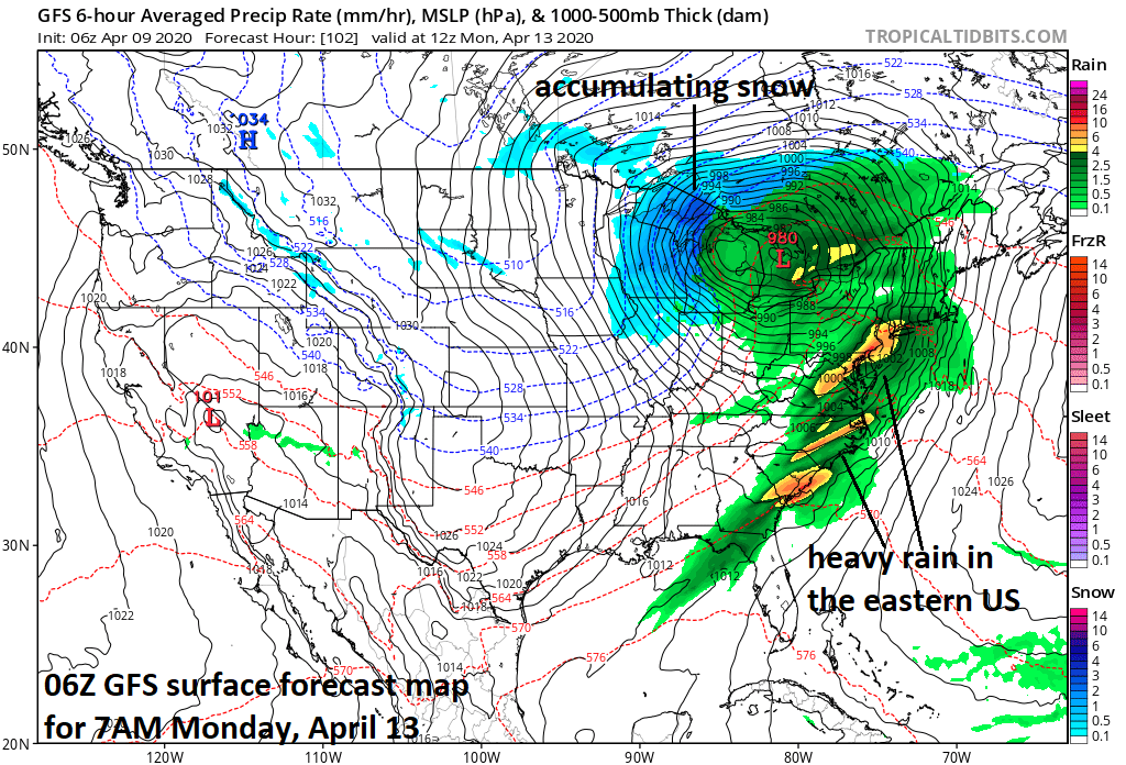
A major storm will have a wide-ranging impact on much of the nation from Sunday into Monday including heavy rainfall, accumulating snow and severe weather. Map courtesy NOAA, tropicaltidbits.com
In the southern US and in the storm’s warm sector, there will be an influx of very warm and humid air from the Gulf of Mexico. In addition, low level winds will be quite strong on the southeast side of the developing low pressure system. As a result, the threat exists for a widespread severe weather outbreak centered on Easter Sunday in the southern states likely extending from Texas/Louisiana to the Carolinas. In the Mid-Atlantic region, this storm will spawn a secondary low and the combination will likely result in a heavy rain event on Sunday night and Monday for places like DC, Philly and NYC. On the storm’s northwest (cold) side, there is likely to be accumulating snow in the Upper Midwest in places like Wisconsin and the Upper Peninsula of Michigan.

Today’s cold air outbreak in the Mid-Atlantic/NE US will be followed by another by the middle part of next week and more are likely to follow as we progress through the latter half of April. Map courtesy NOAA, tropicaltidbits.com
Another cold air outbreak is destined to follow this major storm and likely reach the eastern states on Tuesday. Once this cold air mass arrives, a colder-than-normal weather pattern may actually become quite sustained across the central and eastern US through the remainder of the month of April. This doesn’t mean that each and every day will be colder-than-normal in these areas, but it does mean that we are likely to see below-normal averages for the second half of the month in much of the central and eastern US…and a continuation of an active overall weather pattern.
Meteorologist Paul Dorian
Perspecta, Inc.
perspectaweather.com
Follow us on Facebook, Twitter, YouTube
Video discussion: