
11:20 AM | ***Very chilly air mass for this time of year reaches the Mid-Atlantic/Northeast US by the early part of the upcoming weekend…snow is even possible in higher elevation interior locations***
Paul Dorian
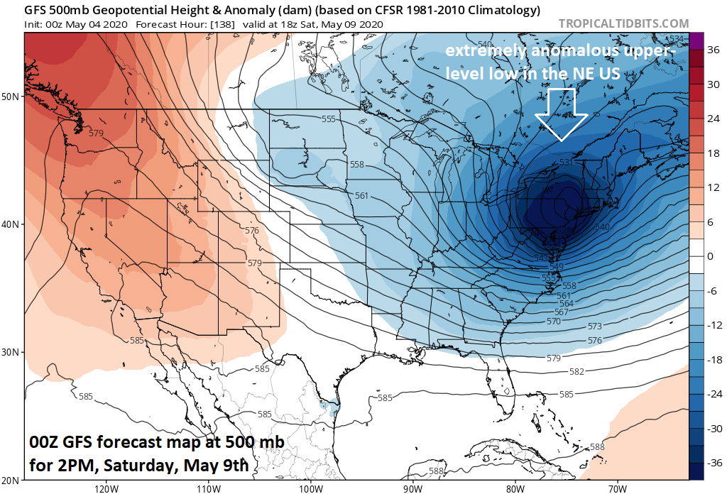
An extremely anomalous upper-level low will likely be situated over the Northeast US by the early part of this upcoming Mother’s Day weekend. Map courtesy NOAA, tropicaltidbits.com
Overview
The contrast between this past weekend and next weekend will be quite remarkable in the Mid-Atlantic region and Northeast US. An unusually cold air mass for this time of year will drop into the Mid-Atlantic and Northeast US by the early part of the upcoming Mother’s Day weekend and it will contrast markedly with the above-normal temperatures experienced this past Saturday and Sunday. In fact, the chill that is headed this way for the late week/weekend may very well result in near record lows across a wide region of the nation extending from the Rockies to the eastern seaboard and snow is even a possibility in the interior higher elevation locations of the Mid-Atlantic and Northeast US. Cold air outbreaks from Canada into the central and eastern US will quite likely continue until at least the middle of the month May.

A widespread area of colder-than-normal temperatures will extend this weekend across the eastern two-thirds of the nation. Map courtesy NOAA, tropicaltidbits.com
Details
All signs point to an unusually cold air outbreak for the central and eastern US late this week and for the upcoming Mother’s Day weekend. Some computer forecast models suggest near record lows for a large region of the country extending from the central US to the eastern seaboard. One example that the upcoming air mass means business is a forecast by the 00Z Euro of around -10 degrees (C) at ~5000 feet over Pittsburgh on Saturday morning - the lowest temperature at that level since the 1950’s is -9.3 degrees (C) for the entire month of May.

Snow is also a possibility by the early part of the weekend in interior higher elevation locations of the Mid-Atlantic/Northeast US. Map courtesy NOAA, tropicaltidbits.com
The anomalous pattern at even higher levels of the atmosphere is equally as impressive by the early part of the weekend. Indeed, the forecast map of 500 millibars height anomalies for Saturday morning features far below-normal heights associated with an upper-level low that may be sitting right over the Northeast US. This type of feature in the upper part of the atmosphere would likely result in quite an unstable environment that could result in snow shower activity – perhaps even some snow squalls – in parts of the Mid-Atlantic and Northeast US. In fact, there some accumulating snow is on the table by this weekend for higher elevation interior locations of the Mid-Atlantic/Northeast US (e.g., upstate PA, NY). A similar type of event took place in May of 1977 (9th, 10th) with accumulating snow from eastern NY through interior New England….even Boston and Providence had measurable snowfall during that particular event. Another unusual outbreak of cold air and snow in the Northeast US took place in May 2002 (17th, 18th).
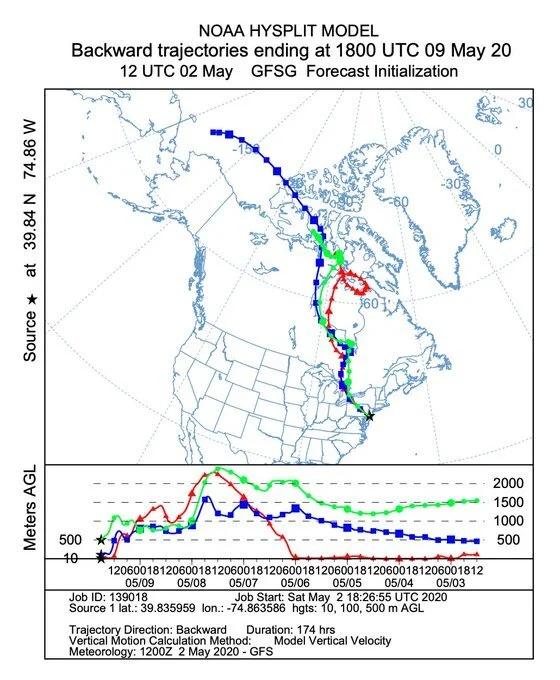
This “backward trajectory” forecast map indicates the air mass coming to the Mid-Atlantic region by the early part of the upcoming weekend will have its origins north of Alaska. Map courtesy NOAA
Looking ahead and also looking elsewhere, the pattern that continues to bring cold air outbreaks into the central and eastern US looks like it will continue into at least the middle of the month of May. At the same time the central and eastern US is chilled, strong high pressure ridging along the west coast of the US and Canada will bring much warmer-than-normal weather to those parts of North America with the potential for record-breaking heat.
Meteorologist Paul Dorian
Perspecta, Inc.
perspectaweather.com
Follow us on Facebook, Twitter, YouTube
Video discussion: