12:10 PM (Tuesday) | *Massive dust plume has reached the Caribbean Sea turning skies brownish…it could eventually reach all the way into the Mid-Atlantic region*
Paul Dorian

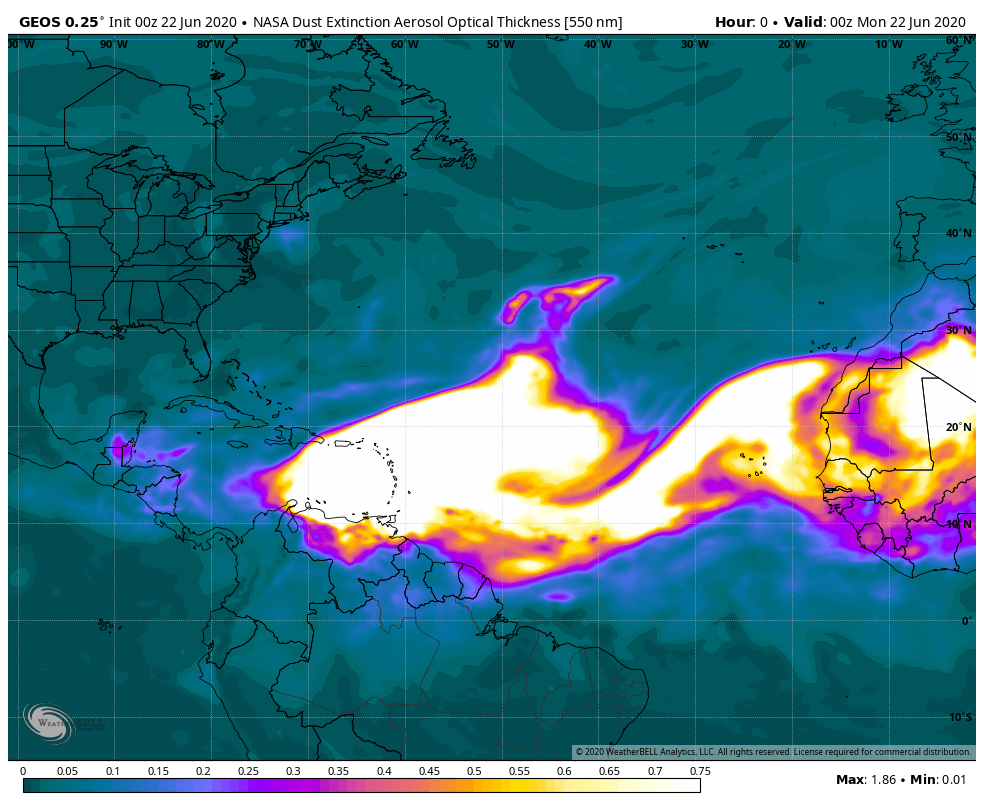
NASA’s GEOS-5 model 10-day forecast of “aerosol optical thickness” suggests that a dry, dusty desert air mass could move from the south-central states to the Mid-Atlantic region later this weekend. Maps courtesy NASA, NOAA, WeatherBELL Analytics
Overview
An unusually large and intense outbreak of dry, dusty air from northern Africa has crossed the Atlantic Ocean and is now turning skies brownish in the Caribbean Sea. There is a possibility that some of this dusty air mass makes it all the way into the Ohio Valley and Mid-Atlantic later this weekend after first moving over the southern US. This layer of dust is commonly referred to as the Saharan Air Layer (SAL) which is a mass of very dry, dusty air that forms over the Sahara Desert in northern Africa during the late spring, summer, and early fall and it can move westward over the tropical North Atlantic on a regular basis during the Atlantic Basin tropical season. SAL activity usually ramps up in mid-June and peaks in mid-August and sometimes the individual outbreaks can cover vast portions of the Atlantic Ocean and reach as far west as the central US and Central America.
The SAL has unique properties of dry air, strong winds and warmth that can have a significant inhibiting effect on the formation and/or intensification of Atlantic Basin tropical systems - at least on a temporary basis. In addition to its potential inhibiting effect on tropical activity in the Atlantic Basin, dusty air masses that travel over the Atlantic Ocean from Africa can actually have long term impacts on beaches in the Caribbean and soils in the Amazon. This particular outbreak of dry, dusty air is more widespread than usual - perhaps one of the most massive in several decades - and it likely formed during mid-June when strong winds from thunderstorms kicked up dust to an altitude of about 20,000 feet or so over the Sahel region of northern Africa.

The 2020 Atlantic Basin tropical season has gotten off to a quick start with four named systems already, but there is a lull in activity now in areas of the tropical Atlantic that have been infiltrated with the dusty air mass. Map courtesy NOAA/NHC
2020 Atlantic Basin tropical season is off to a quick start
The 2020 Atlantic Basin tropical season officially began on June 1st and it has gotten off to a rather fast start with four named systems already in the young season. Tropical Storms Arthur and Bertha formed during the month of May even before the “official” season got underway marking the sixth consecutive year with pre-season systems. In fact, this is the first time since 2012 that two or more storms formed in the month of May. Tropical Storm Cristobal became a named system on June 2nd and ultimately, it impacted the entire Mississippi Valley region from Louisiana to the Canadian border as it penetrated unusually far inland for a tropical system; especially, for the month of June. Tropical Storm Cristobal weakened and became extra-tropical by June 9th and there has been no newly named storm since that point in time. A “just-named” fourth tropical storm (Dolly) has developed well north of the dusty air mass and it should move northeast into the North Atlantic over the next couple of days. Certainly, one of the main reasons that activity has subsided in the region between the west coast of Africa and the Caribbean Sea is the fact that the large and intense Sahara Desert air mass has penetrated into this part of the tropical Atlantic Ocean.

“Before” (top) and “After” (bottom) photographs from Antigua Island in the Caribbean showing the impact of the intense dust plume on sky conditions (courtesy Twitter, cbsnews, PS Express).
Inhibiting effect on tropical activity – at least on a temporary basis
Saharan Air Layer’s dry, dusty air has about 50% less moisture than the typical tropical atmosphere according to NOAA. This layer of dust finds its origins in the Sahara Desert region of northern Africa and it typically resides between 500 and 850 millibars or 1500-5000 meters above the surface. This type of very dry (and dense) air can weaken a tropical cyclone by producing downdrafts around the storm or it can prevent one from actually forming in the first place. In addition, there are typically rather strong winds in the SAL (25-55 mph) which can substantially increase the vertical wind shear in and around the storm environment. This “mid-level jet” of enhanced winds, typically found at a height of 6,500-14,500 feet, can cause “tilting” of the tropical cyclone vortex with height which can disrupt the storm’s internal heat engine. Furthermore, the SAL’s warmth can act to stabilize the atmosphere which, in turn, can inhibit the formation of clouds over the tropical Atlantic Ocean. This stabilizing effect is produced when the Saharan Air Layer’s warm, buoyant air rides above relatively cooler and denser marine air of the Atlantic Ocean. In other words, since the SAL is warmer and drier than the surface of the Atlantic Ocean, it functions as a temperature inversion - rising temperatures with height – and this has a stabilizing effect on the atmosphere. The Saharan Air Layer’s suspended mineral dust also absorbs sunlight, which helps to maintain its warmth as it crosses the Atlantic Ocean.
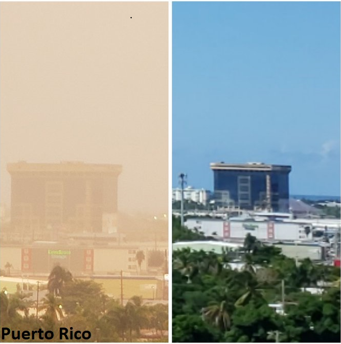
“Before” (right) and “After” (left) photographs from Puerto Rico showing the impact of the intense dust plume on sky conditions (courtesy Twitter, cbsnews).
Dusty air mass could make it all the way to the Ohio Valley and Mid-Atlantic
High-resolution computer forecast models such as NASA’s Goddard Earth Observing System Model, Version 5 (GEOS-5) suggest that the current outbreak of Saharan Desert air can reach the south-central US in coming days and then perhaps into the Mid-Atlantic region later this weekend. NASA’s GEOS-5 global atmospheric model is built on satellite data and it can provide up to a 10-day forecast of “aerosol optical thickness” among other things. In general, brighter colors that appear in the forecast loop represent thick aerosols while dull, darker colors are thin aerosols. Synoptic-scale computer forecast models such as NOAA’s GFS indicate strong high pressure will form over the Southeast US by Saturday and this could certainly result in the dusty air mass circulating around from the south-central US to the Ohio Valley and Mid-Atlantic region by the latter part of the weekend.

Dusty air can flow from the south-central US to the Mid-Atlantic region later in the upcoming weekend on the backside of strong high pressure which will be centered over the Southeast US. Map courtesy NOAA, tropicaltidbits.com
Other impacts
In addition to its potential impact on tropical activity in the Atlantic Basin, this dusty air mass can make sunrises and sunsets much more colorful than normal with a reddish or orange tint to the skies so be on the lookout for that in coming days, first in the southern US and then perhaps as far north as the Ohio Valley and Mid-Atlantic region later this weekend and early next week. The presence of dust in the mid and upper levels of the atmosphere creates an air mass that is rather dense and more apt to scatter red and orange light rays at sunset and sunrise.
Every year huge quantities of soil dust are carried by trade winds from Africa, across the Atlantic, and to the Caribbean. No other ocean region is so extensively and persistently impacted by such high concentrations of dust, a region that extends over 7000 kilometers from the coast of Africa to the Caribbean and to the bounding continental shores of the Americas. In effect, the Caribbean Basin can be thought of as the “receptor” site of the Saharan dust “source,” a source that accounts for over half of global dust emissions. Migrating dust helps to build beaches in the Caribbean over the long term and it actually fertilizes soils in the Amazon. According to a recent publication, the arid regions of North Africa are estimated to emit about 800 Tg yr−1 of soil dust each year, 70% of the global total and six times more than the next largest source, Asia.
Meteorologist Paul Dorian
Perspecta, Inc.
perspectaweather.com
Follow us on Facebook, Twitter, YouTube
Detailed video discussion on the Saharan Air Layer (SAL) atmospheric phenomenon: