11:00 AM (Friday) | ***Tropical Storm Fay continues to pound away at the eastern Mid-Atlantic...now with 60 mph maximum sustained winds***
Paul Dorian
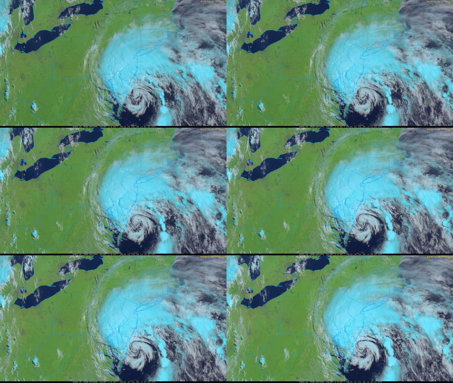
The latest satellite imagery loop of Tropical Storm Fay (courtesy College of Dupage, NOAA)
Overview
Heavy rain bands are rotating around Tropical Storm Fay at this hour and extending northwestward into eastern Pennsylvania, northern New Jersey and southeastern New York. There has already been a boat load of rain over the Delmarva Peninsula with several inches in some spots and flooding has been prevalent in some Delaware beach towns such as Bethany Beach. Tropical Storm Fay will continue to push in a general northerly direction over the next several hours though it could bobble around at times in slightly different directions. The storm’s center is likely to push through New Jersey from south-to-north later today and then continue northward tonight into the Hudson Valley region of New York State.
This loop of “total precipitable water” features very high moisture levels associated with Tropical Storm Fay leading to very heavy rainfall in the eastern Mid-Atlantic. Courtesy of University of Wisconsin/CIMSS, NOAA
Details
The latest measurements on Tropical Storm Fay show a central pressure of 999 millibars with maximum sustained winds at 60 mph. This central pressure is a bit lower than the readings from earlier this morning showing some intensification as the circulation center has remained over water and the winds have picked up slightly. The center of TS Fay will push into southern New Jersey shortly and then ride northward through the state later in the day. Heavy rain will continue for awhile longer over the Delmarva Peninsula and will continue to spread northwestward through eastern PA, New Jersey and southern portions of New York State. Given the already well-saturated grounds the the Mid-Atlantic region, flooding is an increasing concern in the eastern Mid-Atlantic and National Weather Service “flood advisories” have been placed in many areas of southern New Jersey and the Delmarva Peninsula. The DC metro region has escaped any heavy rainfall associated with TS Fay and there could actually be some sunshine there later in the day. By later tonight, Tropical Storm Fay will push northward into the Hudson Valley region of New York State.
The official position of Tropical Storm Fay as of 11 AM Friday. (Courtesy NOAA)
In addition to the rain, there will be strong winds today of 50+ mph along coastal sections of the Mid-Atlantic region as Tropical Storm Fay pushes to the north. Also, as is somewhat typical of land falling tropical systems, there is a threat for isolated tornadic activity on the east side of a south-to-north storm track. In this particular case, that would suggest to be on the lookout later today across eastern New Jersey during any embedded thunderstorm activity that might develop. Strong rip currents are also likely to form in the western Atlantic Ocean and these could stick around right through the upcoming weekend.
Looking beyond the tropical storm, it’ll remain unsettled this weekend and early next week in much of the eastern US with a frontal system to deal with and then an impressive upper-level trough. As a result, there will be a daily shot of showers and thunderstorms from Saturday into at least Tuesday of next week. The second half of next week could feature some rather hot weather conditions across the Great Lakes, Northeast US and Mid-Atlantic.
Meteorologist Paul Dorian
Perspecta, Inc.
perspectaweather.com
Follow us on Facebook, Twitter, YouTube
Video discussion:


