1:50 PM (Tuesday) | *Strong storms possible later today in the I-95 corridor…severe storms possible later tomorrow…an active tropical scene in the Atlantic Basin*
Paul Dorian

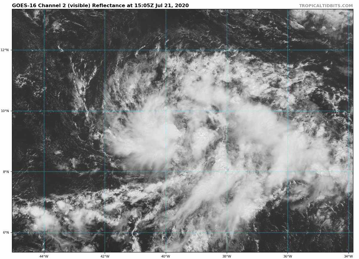
GOES-16 satellite imagery shows better organization today of a strong tropical wave over the central Atlantic. This system has a very good chance of further intensification in the near-term and could become a tropical depression by later today or tonight. Courtesy NOAA
Overview
A wave of energy in the upper part of the atmosphere is combining with a stalled out frontal boundary zone and plenty of moisture to spark some strong thunderstorm activity in the western part of the Mid-Atlantic region and some of these cells will make it into the I-95 corridor at day’s end. An even stronger wave of energy aloft will likely generate thunderstorms later tomorrow for the Mid-Atlantic region and some of these can reach severe levels with heavy rainfall, hail and potential damaging wind gusts. Elsewhere, the Atlantic Basin tropical scene has become more active with two systems to monitor over the next few days and additional waves are drifting westward over Africa assuring an active last stretch of the month of July.
Thunderstorms have fired up this afternoon across the western Mid-Atlantic and some of these make make it into the I-95 corridor by the end of the day. Courtesy University of Wisconsin, NOAA
Thunderstorm threat(s) for the Mid-Atlantic
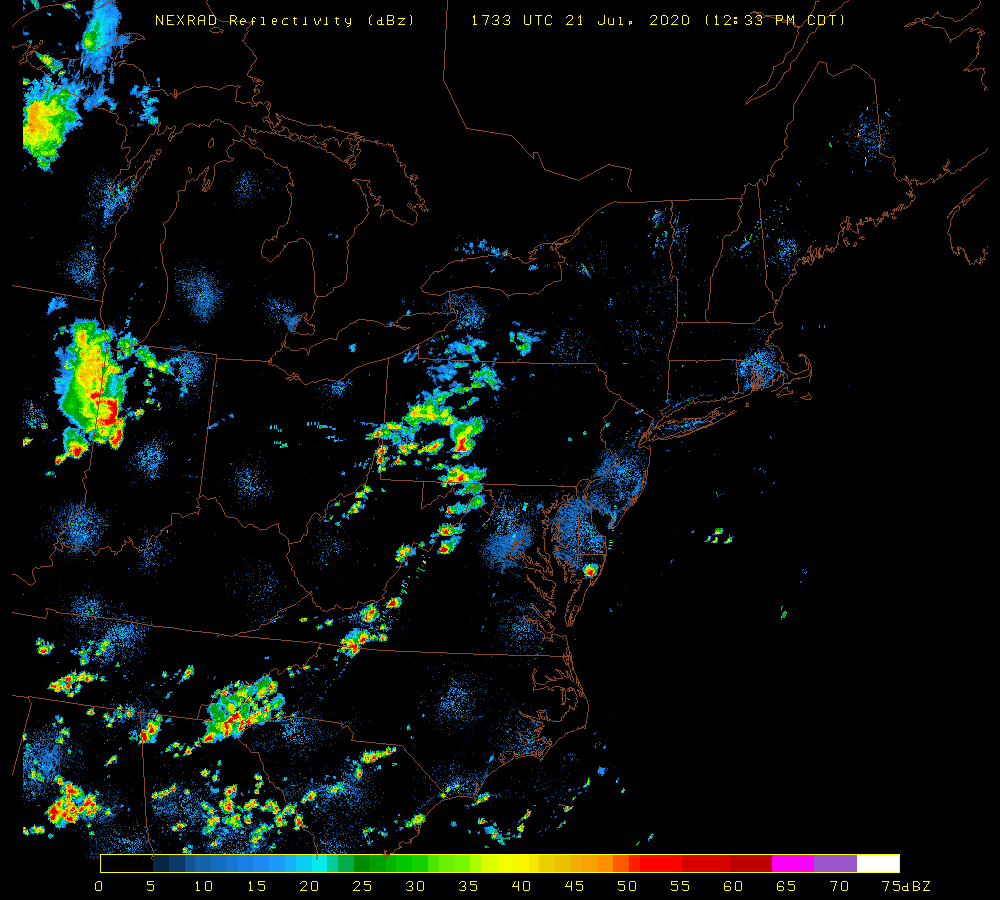
Hot and humid conditions continue today in the Mid-Atlantic region with temperatures in the 90’s at mid-day in most spots along the I-95 corridor. Thunderstorms have formed across the western Mid-Atlantic region as upper-level energy moves overhead with these storms extending from western PA to western VA and they are moving fairly rapidly from west-to-east. As a result, the chance for thunderstorms will increase markedly in the DC-to-Philly-to-NYC corridor later today and early tonight and some of these storms can be strong with gusty winds and brief heavy rainfall.

A piece energy in the upper atmosphere will move on top of the I-95 corridor by this evening contributing to the threat of thunderstorm activity in the DC-to-Philly-to-NYC corridor. Courtesy NOAA, tropicaltidbits.com
An even better chance for thunderstorms will develop later tomorrow as a stronger wave of energy drops southeastward into the Mid-Atlantic region from the eastern Great Lakes. The energy aloft will interact with moist and unstable air already in place in the Mid-Atlantic. Any storm late tomorrow could be on the severe side with potential damaging wind gusts and heavy rainfall. Another in a series of upper-level short wave troughs will move across the Mid-Atlantic region on Thursday and this is likely to result in more shower and thunderstorm activity and some of the storms can be strong-to-severe. Some relief in the recent excessive heat and humidity will arrive in the Mid-Atlantic on Friday following the passage of a frontal system and it should remain close-to-seasonal norms for Saturday. Looking ahead, a buildup of heat and humidity is likely once again for much of the eastern US as we head into the early part of next week.

Even stronger energy in the upper atmosphere will move on top of the I-95 corridor by early tomorrow evening and this will contribute to the threat of severe thunderstorm activity in the DC-to-Philly-to-NYC corridor. Courtesy NOAA, tropicaltidbits.com
An active tropical scene
A few noticeable tropical waves pushed across Africa last week and have now activated the Atlantic Basin during this week. One wave is currently located over northern Cuba and the Florida Straits and a second and more impressive wave is pushing across the central tropical Atlantic. The initial wave will push into the central Gulf of Mexico on Wednesday and then the northwestern Gulf region on Thursday and Friday. This system has about a 50/50 chance of intensify into tropical storm status over the next couple of days while it is out over the open warm waters of the Gulf of Mexico.

Wave #1 is located near northern Cuba and the Florida Straits…wave #2 is out over the central tropical Atlantic and another tropical wave can be seen over western Africa…all of these systems assure an active remainder of July in the Atlantic Basin. Courtesy University of Wisconsin/CIMMS
An even better chance for intensification will take place with the second tropical wave now over the central tropical Atlantic about midway between the west coast of Africa and the Lesser Antilles. Satellite imagery and wind data suggest that this system is much better organized today compared to yesterday and has an excellent chance of becoming a tropical depression as soon as later today. Its chances for reaching tropical storm status are very high as well given the amount of time it is likely to out over the warm waters of the tropical Atlantic. If this system does become a named tropical storm it would be “Gonzalo” and the 7th named system of this still relatively young tropical season. The current record for the “earliest” 7th named tropical system in the Atlantic Basin is “Gert” on July 24th, 2005. While the “number” of tropical systems is very high for this early in the Atlantic Basin tropical season, the Accumulated Cyclone Energy (ACE) is actually at a record low for having had six named storms. ACE factors in both the strength and duration of a tropical system and it is really a better overall measure of tropical activity compared to the number of storms. All of these tropical waves assure us a pretty active scene in the Atlantic Basin as we progress through the remaining stages of the month of July.
Meteorologist Paul Dorian
Perspecta, Inc.
perspectaweather.com
Follow us on Facebook, Twitter, YouTube
Video discussion: