1:35 PM | ***Low pressure that should become T.S. Fay threatens the eastern Mid-Atlantic with flooding rainfall…threat zone includes Delmarva Peninsula, eastern PA, New Jersey and southern New York***
Paul Dorian

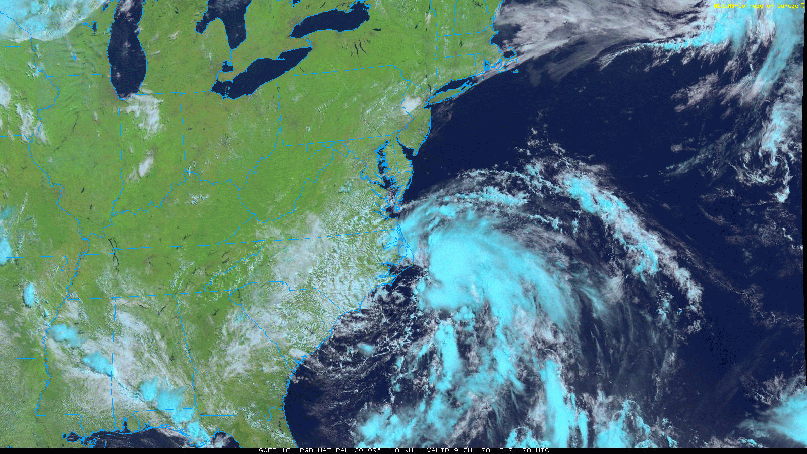
Satellite imagery shows thick clouds just off the coast with a circulation center near the coastline of North Carolina. Imagery courtesy NOAA (GOES-16), College of DuPage
Overview (Thursday PM)
The main focus today is on a low pressure system over the coastal sections of North Carolina as it poses a threat for heavy rainfall on Friday in the eastern Mid-Atlantic region. This system is likely to push to the northeast during the next several hours out over the warm waters of the western Atlantic and then make a move in a more northerly direction likely reaching a position over the southern half of the Delmarva Peninsula by early tomorrow. There is a good chance that when this system moves out over the ocean later today, it’ll intensify enough to become a “named” tropical storm (would be “Fay”). Whether or not it becomes a "named" storm, it has the potential to produce very heavy rainfall on Friday in the eastern part of the Mid-Atlantic region along with quite gusty winds along coastal sections.

The high-resolution (3-km) version of NOAA’s NAM computer forecast model has low pressure over the Delmarva Peninsula as of early Friday. Map courtesy NOAA, tropicaltidbits.com
Details
While isolated showers cannot be ruled out for this afternoon and evening in the Mid-Atlantic region, today’s weather represents a break in the action from recent active days. Meanwhile, bands of showers and thunderstorms are now affecting eastern North Carolina and southeastern Virginia and the rain is even more concentrated just offshore near the Outer Banks of North Carolina. The latest satellite imagery shows a circulation center associated with surface low pressure over the North Carolina coastline and this system is currently somewhat “displaced” from the copious amounts of moisture just offshore. Later today, as this surface low pressure pushes offshore in a northeasterly direction, it is likely to become “better aligned” with the moisture and it should intensify enough to become a “named” tropical storm (would be “Fay”) by NOAA’s National Hurricane Center.

12Z GFS forecast map of total precipitation amounts for the upcoming coastal storm event shows a swath of heavy rainfall in the eastern Mid-Atlantic. Map courtesy NOAA, tropicaltidbits.com
By later tonight, the low pressure system will take a more northerly track and it is likely to push into the southern half of the Delmarva Peninsula by early Friday. Bands of showers and thunderstorms are likely to develop on Friday morning in the eastern Mid-Atlantic region and some of the rain will become heavy at times. The best chance for the very heavy rainfall amounts of at least a few inches will be in the Delmarva Peninsula, eastern Pennsylvania, New Jersey and southern part of New York State. The immediate DC metro region will likely be too far to the southwest for getting in on the heaviest rainfall on Friday with the cutoff zone being around the western side of the Chesapeake Bay.

12Z Euro produces heavy rainfall amounts on Friday in the eastern Mid-Atlantic region. Map courtesy ECMWF, pivotalweather.com
In addition to the rain, there will be gusty winds on Friday associated with what may become Tropical Storm Fay; especially, along coastal sections of the Delmarva, New Jersey and Long Island, NY. In fact, tornadoes are usually a threat with land falling tropical systems; especially, on the east side of the storm track which might mean places like coastal New Jersey later in the day on Friday will be a threat zone. Given the recent heavy rainfall and well-saturated grounds in much of the Mid-Atlantic region, flash flooding is likely to become a serious concern on Friday and Friday night. Strong rip currents are also likely to form in the western Atlantic Ocean and these could stick around right through the upcoming weekend. By later tomorrow night, the low pressure system is likely to push northward through the Hudson Valley region of New York State bringing significant rainfall to portions of the Northeast US.

NOAA’s National Hurricane Center is closely monitoring low pressure over the coast of North Carolina as it could intensify enough later today or tonight to become a “named” tropical storm (“Fay”).
Looking beyond the coastal storm, it’ll remain unsettled enough this weekend for the chance of showers and thunderstorms in the Mid-Atlantic region. In addition, an impressive upper-level trough will drop southeastward from the Great Lakes by early next week and intensify in the eastern US. As a result, there will continue to be the threat for showers and thunderstorms for much of the eastern third of the nation on Monday and Tuesday and then the second half of next week could feature some hot weather across the Great Lakes, Northeast US and Mid-Atlantic.
Meteorologist Paul Dorian
Perspecta, Inc.
perspectaweather.com
Follow us on Facebook, Twitter, YouTube
Video discussion: