
12:00 PM (Wednesday) | ***Torrential downpours and flash flooding threat continues in the Mid-Atlantic region***
Paul Dorian
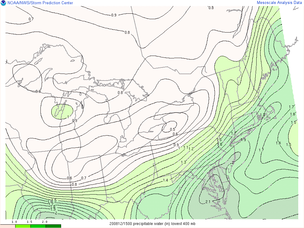
Several ingredients are coming together for heavy rainfall in the I-95 corridor region of the Mid-Atlantic including very high moisture levels in the atmosphere which are confirmed by high “precipitable water” levels shown on this map (courtesy NOAA).
Overview
The overall weather pattern will remain quite unsettled in the Mid-Atlantic region over the next several days with the threat for more torrential downpours with rates of 2+ inches per hour and flash flooding conditions. The combination of an extremely humid air mass, a stalled out frontal boundary zone, and multiple low pressure systems should be able to provide enough “lift” in the atmosphere to result in heavy rainfall in coming days and given the already well-saturated grounds, this can lead to some serious flash flooding. In fact, there were torrential downpours in the pre-dawn hours across northern Virginia that resulted in damage to roadways in places like Manassas Park and the entire DC-to-Philly-to-NYC corridor remains under “flash flood watches” as a result of the potential for more heavy rainfall and saturated grounds.

A high-resolution (3-km) version of NOAA’s NAM computer forecast model indicates that there will be scattered showers and thunderstorms by mid-afternoon in the Mid-Atlantic region. Any shower or thunderstorm that forms later today can be slow-moving and produce heavy rainfall. Map courtesy NOAA, tropicaltidbits.com
Details
The ingredients are in place for significant rainfall in the Mid-Atlantic region over the next few days with extremely humid air with dew points in the mid-to-upper 70’s and a stalled out frontal boundary system. This relatively stationary frontal boundary zone will act as a conduit for low pressure systems to ride along in coming days and this should provide enough “lift” in the atmosphere to “squeeze out” the excessive moisture and produce heavy rainfall.

The dew point temperature is a good measure of overall moisture content and they are very high for this area well up in the 70’s in some spots. Map courtesy NOAA/Philly NWS
Any shower or thunderstorm that forms later today will likely be slow-moving as a result of weak winds and virtually no shear and that raises the chance for substantial rainfall amounts in a particular spot. This same type of pattern with slow-moving storm cells will likely continue tonight, tomorrow - and perhaps right through the upcoming weekend.

Soil moisture levels are quite high in the I-95 corridor region of the Mid-Atlantic (circled area) thanks in large part to last week’s excessive rainfall associated with Tropical Storm “Isaias”. Map courtesy NOAA
Grounds are already well-saturated in the I-95 corridor region of the Mid-Atlantic thanks in large part to the significant rainfall of last week that occurred with the passage of Tropical Storm “Isaias”. In fact, some spots received as much as 6 or 7 inches of rain as the tropical system barreled northward through the region and soil moisture is still well above-normal in much of the Mid-Atlantic. Earlier this morning, a batch of showers and thunderstorms pushed through northern Virginia and resulted in a quick buildup of water which caused damage to a roadway in Manassas Park by opening up a sink hole.

Heavy rainfall caused flash flooding earlier today in the Manassas Park region of northern Virginia with damage to a roadway as a sink hole opened up. The threat for additional heavy rainfall and flash flooding will continue for later today, tonight and perhaps right into the upcoming weekend.
This batch of showers and thunderstorms has since dissipated, but additional showers and thunderstorms will re-form later today and likely continue to form tonight as well. Any shower or thunderstorm that forms both later today and tonight can produce heavy rainfall amounts in a short period of time and this may be a repeat performance each of the next few days.
Meteorologist Paul Dorian
Perspecta, Inc.
perspectaweather.com
Follow us on Facebook, Twitter, YouTube
Video discussion: