11:20 AM (Thursday) | ***Torrential downpours and flash flooding threat to continue through the weekend in parts of the Mid-Atlantic; especially, south of the PA/MD border***
Paul Dorian

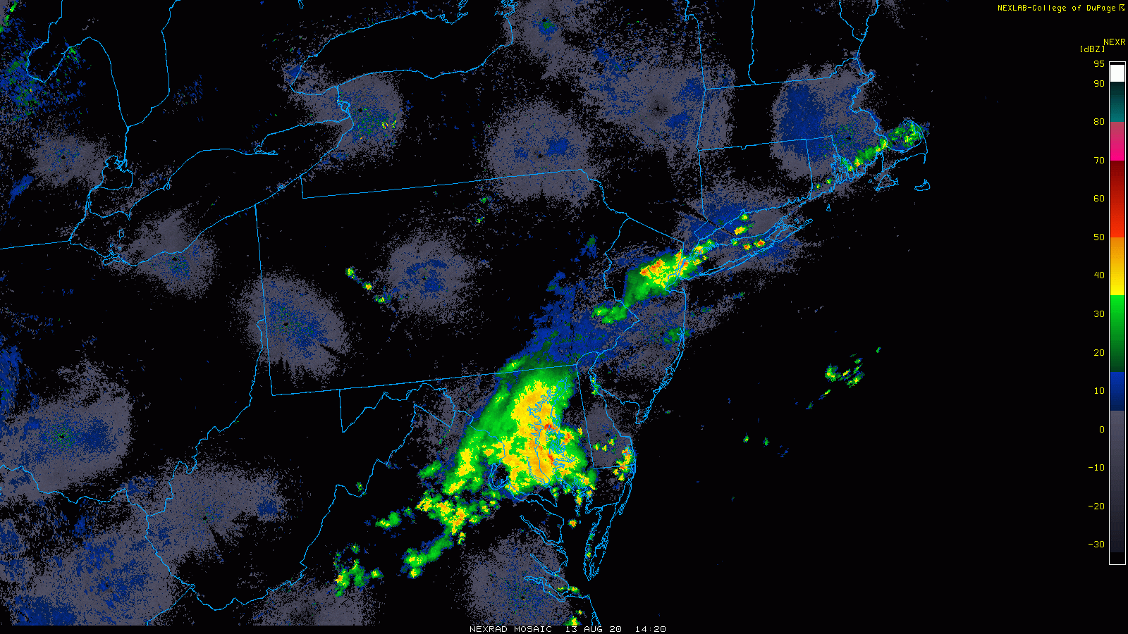
A batch of showers and thunderstorms that drenched the DC metro region this morning is pushing to the northeast towards southeastern PA, the Delmarva Peninsula and southern New Jersey. Imagery loop courtesy NOAA, College of DuPage
Overview
The overall weather pattern will remain very unsettled in parts of the Mid-Atlantic region right though the upcoming weekend with the threat for more torrential downpours and localized flash flooding; especially, south of the PA/MD border. The combination of an extremely humid air mass, a stalled out frontal boundary zone, and multiple low pressure systems should provide enough “lift” in the atmosphere to continue to produce heavy rainfall with rain rates of 2+ inches per hour. Given the already very well-saturated grounds, this additional rainfall can lead to some serious localized flash flooding conditions. With limited wind flow in the lower atmosphere, any shower or thunderstorm that develops in this pattern will be slow-moving and potentially resulting in a few inches of rain over a relatively short period of time.

The air mass is extremely moist at mid-day across the southern half of the Mid-Atlantic region and relatively dry in the Northeast US. Map courtesy NOAA
Details
The ingredients are in place for more significant rainfall in parts of the Mid-Atlantic region over the next few days with extremely humid air (dew points in the 70’s) and a stalled out frontal system. This relatively stationary frontal boundary zone is acting as a conduit for low pressure systems to ride along and each one of these will provide enough “lift” in the atmosphere to “squeeze out” excessive moisture and produce heavy rainfall. Any shower or thunderstorm that forms today and tonight will be slow-moving as a result of weak winds in the atmosphere and this raises the chance for substantial rainfall amounts in a given spot in a short period of time. This same type of pattern featuring slow-moving showers and thunderstorms will likely continue on Friday and perhaps right through the upcoming weekend; especially, in areas south of the Mason-Dixon Line.

Soil moisture levels are quite high in the I-95 corridor region of the Mid-Atlantic thanks to recent heavy rainfall and this is adding to the likelihood of localized flash flooding. Map courtesy NOAA
Grounds are already very well-saturated in the I-95 corridor region of the Mid-Atlantic thanks in part to the significant rainfall of last week that occurred with the passage of Tropical Storm “Isaias” and to the heavy downpours of the last couple of days. Some spots received as much as 6 or 7 inches of rain last week as the tropical storm barreled northward through the region and with the additional rainfall of the last few days, soil moisture levels are well above normal in much of the I-95 corridor region in the Mid-Atlantic.
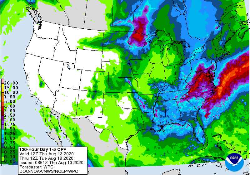
The 5-day forecast map by NOAA of total precipitation amounts between today and Tuesday morning with 3+ inches in parts of the Mid-Atlantic (shown in red). This will quite likely be way underdone in some spots south of the PA/MD border as I expect there can be many spots with several inches of rain in this coming 5-day period. Map courtesy NOAA
Earlier this morning, a batch of showers and thunderstorms pushed through the DC metro region resulting in localized flash flooding and this area of moisture is pushing northeast to the Delmarva Peninsula and towards southeastern PA and southern New Jersey. Another batch of showers and thunderstorms has pushed northeastward from east-central PA and central New Jersey into the New York City metro region. Both the DC and NYC metro regions may experience a lull in the action for awhile this afternoon, but other showers and thunderstorms are likely to re-form later in the day and impact parts of the Mid-Atlantic region with more downpours.
One final note of caution, if driving and water lies ahead of you on the roadway, it is best to turn around as it is often difficult to ascertain just how deep the water may be and how quickly it may be rising.
Meteorologist Paul Dorian
Perspecta, Inc.
perspectaweather.com
Follow us on Facebook, Twitter, YouTube
Video discussion: