11:15 AM (Wed.) | ****Major Hurricane Laura to make landfall later tonight near the Texas/Louisiana border…destructive winds well inland...some impact in the Mid-Atlantic region on Saturday****
Paul Dorian

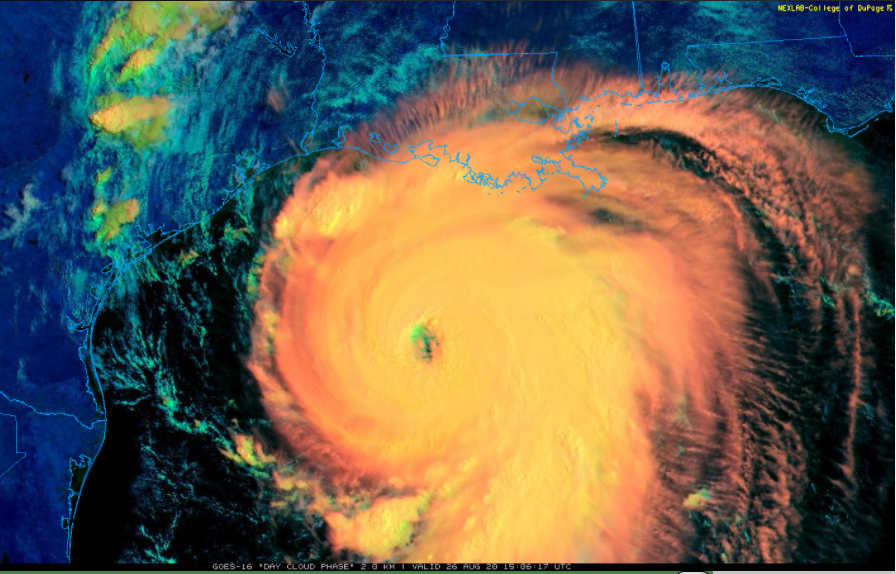
The “eye” of Major Hurricane Laura is becoming more noticeable on satellite imagery as it continues to intensify today on its way to becoming a category 4 storm with a likely landfall later tonight near the Texas/Louisiana border region. Image courtesy NOAA/GOES-East (“Day Cloud Phase”), College of DuPage
Overview
Hurricane Laura has reached “major” hurricane status as a category 3 storm and it should intensify into a category 4 system this afternoon as it heads on a collision course with the Texas/Louisiana border region and expected landfall later tonight. Hurricane Laura intensified rapidly during the past 24 hours in a favorable environment of low wind shear and very warm sea surface temperatures and continues to intensify today - now just a bit under the required levels for a category 4 classification. After Hurricane Laura makes landfall later tonight, its story line will not be over. Its remains will push northward into the south-central states on Thursday producing heavy rainfall, severe weather, and damaging wind gusts. By the early part of the weekend, the remains of Hurricane Laura will turn to the east and get intertwined with a frontal system and an incoming vigorous upper-level trough to potentially produce some heavy rainfall in portions of the Mid-Atlantic region. Once off the Mid-Atlantic coast, the remnants of Hurricane Laura could actually re-intensify as it moves out over the warm waters of the western Atlantic.

The storm surge could be as high as 15-20 feet in coastal regions of extreme eastern Texas and southwestern Louisiana and it may have an impact as far as 30 miles inland. Map courtesy NOAA
Details
“Laura” has climbed to a strong category 3 (“major”) hurricane level - the first “major” hurricane of the 2020 Atlantic Basin season - with maximum sustained winds of 125 mph at 11 AM and a movement to the NW at 16 mph. Hurricane Laura is very likely to attain category 4 status this afternoon as it is only a stone’s throw away at mid-day. In the last 24 hours, Hurricane Laura has undergone significant intensification with its maximum sustained winds climbing dramatically from 75 mph early yesterday to 125 mph by late this morning. The favorable environment that allowed for the rapid intensification included low wind shear and also the very warm waters of the Gulf of Mexico. In fact, sea surface temperatures in the Gulf of Mexico are some of the highest seen anywhere around the world with many spots greater than 30 degrees (C). Earlier this week, Hurricane Laura maintained its intensity level as it passed over the northern Caribbean islands of Hispaniola (Haiti/Dominican Republic) and Cuba and this was an ominous sign and suggestive of a very healthy inner core. These two islands tend to weaken tropical cyclones as their rugged terrain usually has a detrimental effect on the overall circulation field.

Winds will be destructive later tonight along coastal sections of extreme eastern Texas and southwestern Louisiana as Hurricane Laura makes landfall and then well inland on Thursday as the remains push northward. Map courtesy NOAA
Hurricane Laura will continue on a path to the northwest until it reaches the Texas/Louisiana border region later tonight – perhaps around or shortly after midnight. Intensification is likely to continue for the next several hours which should allow for the attainment of category 4 status (maximum sustained winds of 130 mph). The synoptic pattern that is influencing its movement consists of a weak upper-level ridge of high pressure over the Southeast US and an inverted trough hanging over Texas. There is a chance that as the upper-level trough over Texas reasserts itself later today, it may result in increased (southwesterly) vertical wind shear which could, in turn, cause a slight reduction in Laura’s intensity level right near the time of landfall – perhaps from a category 4 to a category 3 (i.e., still would be a “major” hurricane).

This sounding from Lake Charles, Louisiana shows strong southwesterly winds in the upper part of the atmosphere (above 400 millibars) and this wind shear could lead to a bit of weakening at the time of landfall later tonight. Courtesy NOAA, Levi Cowan (Twitter)
In general, the worst impact of an incoming hurricane on the Gulf coast is to the right of the storm track. Counter-clockwise winds around the approaching storm will tend to be “enhanced” on the right side of the storm track by the forward speed of the storm and this can also increase the storm surge in that particular region. In this case, the right side of the storm track is likely to be in the southwestern part of Louisiana and perhaps in extreme eastern Texas. Perhaps somewhat surprisingly, there have not been many “major” hurricane strikes over the years within 50 miles of the Texas/Louisiana border with the known short list as follows: Unnamed storm 1886, Unnamed storm 1918, Audrey 1957 and Rita 2005. There have been three category 4 hurricanes on record to have made landfall anywhere along the Louisiana coastline.

This is a radar image of Hurricane Audrey (June 1957) just before landfall in the same Texas/Louisiana border region that Hurricane Laura is expected to strike later tonight. Hurricane Audrey is the strongest hurricane ever recorded in the Atlantic Basin during the month of June. It was originally classified as a category 4 storm when it made landfall in 1957, but has since been re-classified by NOAA to a category 3. Image courtesy Wikipedia.
Post-landfall…destructive winds well inland…some impact in the Mid-Atlantic region
The remains of Hurricane Laura are likely to push northward into the south-central states on Thursday with heavy rainfall, damaging wind gusts and severe thunderstorm activity. By the early part of the weekend, the remnants of Hurricane Laura will take a turn to the east as it interacts with a frontal system and an incoming upper-level trough that will be moving across the Great Lakes in a northwest-to-southeast fashion. As a result, there can be some heavy rainfall on Saturday in the Mid-Atlantic region with possible strong-to-severe thunderstorm activity. Once the remains of Hurricane Laura push off the Mid-Atlantic coastline later this weekend, there could actually be some re-intensification as it pushes over the warm waters of the western Atlantic and on its way out-to-sea.

The east coast often becomes quite vulnerable to a tropical storm hit when there is upper-level ridging over the Northeast US/SE Canada this time of year. Indeed, the overall upper air pattern changes from the current 5-day period (left) with an upper-level trough over the NE US to one with an upper-level ridge (right) in days 10-14 (Sept 04-Sept 09). Maps courtesy NOAA, tropicaltidbits.com
Looking ahead, the overall weather pattern may be setting up for an east coast hit by a tropical system as we get to around the 10th of September or so as the current upper-level trough in the Northeast US reverses over the next couple of weeks to an upper-level ridge and this often opens the door for an east coast hit…stay tuned
Meteorologist Paul Dorian
Perspecta, Inc.
perspectaweather.com
Follow us on Facebook, Twitter, YouTube
Video discussion: