
11:30 AM (Thursday) | *Remnants of Hurricane Laura to impact the Mid-Atlantic on Saturday as it interacts with an incoming frontal system…spectacular air mass to follow for Sunday and Monday*
Paul Dorian

This 24-hour loop of integrated microwave imagery shows well the location of landfall last night in the southwestern part of Louisiana. Images courtesy University of Wisconsin/SSEC, NOAA
Overview
Hurricane Laura came ashore last night near the town of Cameron in southwestern Louisiana initially estimated as a category 4 storm. It has pushed northward today into upstate Louisiana and has weakened along the way to a category 1 hurricane; however, it is still producing heavy rainfall and damaging wind gusts and will continue to do so into the state of Arkansas and parts of the Tennessee Valley. By the weekend, the remains of Hurricane Laura will interact with an incoming frontal system and upper-level trough to produce some heavy rainfall in the Mid-Atlantic region along with the potential for strong-to-severe thunderstorms. All of this activity will clear the east coast by Sunday and a spectacular air mass for late August will push into the Great Lakes, Northeast US and the Mid-Atlantic region.

Preliminary ground-level reports of winds are listed here with the highest gust of 132 mph measured at Lake Charles, Louisiana. Note- If these actual reports hold true as the highest measurements on the wind then the classification of a category 4 storm at landfall may very well be reduced in the future by NOAA with further analysis. Courtesy crankyweatherguy, Twitter.
Details
Hurricane Laura became one of the strongest hurricanes to ever make landfall in Louisiana last night as it came ashore with estimated maximum sustained winds of 150 mph (i.e., initially estimated as a category 4). Preliminary reports of actual ground observations show the highest wind gust to be 132 mph measured at Lake Charles and the highest sustained winds of 101 mph at Cameron in the southwestern part of Louisiana. The hurricane has weakened today as it pushes northward through Louisiana, but it is still producing heavy rainfall and damaging wind gusts and it should reach the central part of Arkansas by around midnight -likely to have been downgraded to tropical storm status by that time. Strong winds and heavy rain is likely to continue into Friday across the Tennessee Valley as Laura’s remains likely get downgraded even further from tropical storm status to tropical depression.

A listing is shown here of the most intense hurricanes to have made landfall in the state of Louisiana. Note- if the ground-level highest wind reports (above) hold true then the classification of a category 4 storm at landfall may very well be reduced in the future by NOAA with further analysis. Courtesy Philip Klotzbach, Twitter
After that, the remains of Hurricane Laura will begin to be influenced by an upper-level trough of low pressure that will be dropping southeastward from central Canada and into the Great Lakes. A cold frontal system will accompany this incoming upper-level trough and they will interact with the remains of Laura on Saturday to produce some heavy rainfall and also possible strong-to-severe thunderstorms. The threat for showers and thunderstorms will continue into Saturday night, but all of the activity should clear the Mid-Atlantic coastline by Sunday. Once the remains of Hurricane Laura push off the Mid-Atlantic coastline later this weekend, there could actually be some re-intensification as it pushes over the warm waters of the western Atlantic Ocean. The air mass that pushes into the Mid-Atlantic region on Sunday will be very comfortable with pleasant temperatures and humidity levels. The breeze will be fairly strong on Sunday out of the northwest and the very comfortable conditions will continue into Monday as well.
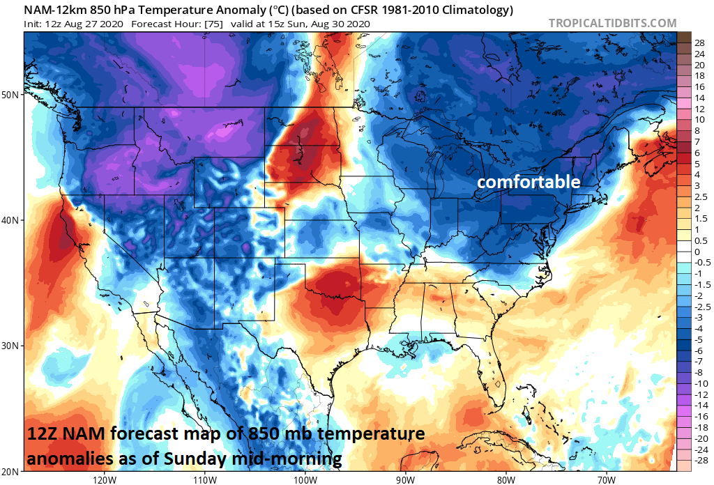
A very comfortable air mass will push into the Northeast US/Mid-Atlantic/Great Lakes on Sunday following the passage of a strong cold front and the remains of Hurricane Laura. Courtesy NOAA, tropicaltidbits.com
One final note on the recent tropical activity, very warm sea surface temperatures in the Gulf of Mexico certainly played an important role in the rapid intensification of Hurricane Laura before landfall; however, it is only one of many factors and, as it turned out, atmospheric conditions were actually more important. Specifically, wind shear in the atmosphere was “weak to non-existent” as Laura pushed over the warm Gulf of Mexico contributing greatly to its rapid intensification in the 24-36 hours before landfall. However, Tropical Storm Marco - which traveled over roughly the same area of very warm sea surface temperatures in the Gulf of Mexico - encountered more significant wind shear which ultimately caused a swift dissipation of that tropical system.

A reversal of the upper air pattern in coming days could “open the door” for a tropical hit on the east coast. Upper-level troughing in the Northeast US will be replaced with upper-level ridging during the next couple of weeks. Maps courtesy NOAA, tropicaltidbits.com
An increasing tropical threat for the east coast
Looking ahead, the door may be opening over the next couple of weeks for an increasing threat of a tropical storm hit along the east coast of the US. The overall weather pattern is about to undergo a transition from the recent upper-level trough situation over the Northeast US to an upper-level ridge. There has been strong high pressure ridging aloft over the southwestern Atlantic in recent days and this resulted in increased tropical activity over the Gulf of Mexico. As ridging builds farther to the northeast over southeastern Canada and the Northeast US, the door could open along the east coast for a west-to-east moving tropical system to strike during the first half of September…stay tuned.
Meteorologist Paul Dorian
Perspecta, Inc.
perspectaweather.com
Follow us on Facebook, Twitter, YouTube
Video discussion: