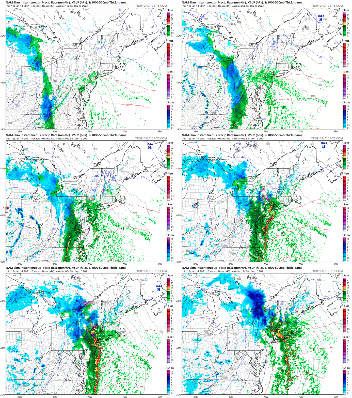
1:30 PM (Thursday) | *Cold front arrives tomorrow night with strong upper-level support…rain and a possible thunderstorm in the Mid-Atlantic…breezy and cold for the weekend with possible snow showers*
Paul Dorian
As a strong cold front reaches the eastern seaboard on Friday night, strong energy aloft will help to spawn low pressure near the coast and this will lead to rain and possible thunderstorms in the Mid-Atlantic. In the interior, higher elevation locations of the Northeast US such as upstate New York, there can be some accumulating snow as colder air arrives. Maps courtesy NOAA, tropicaltidbits.com
Overview
An energetic stretch of weather is coming to the Mid-Atlantic region with the arrival of a strong cold front on Friday night that will lead to periods of rain and a possible thunderstorm or two. On Saturday, deepening low pressure in the upper atmosphere will pass overhead leading to somewhat unsettled conditions with increasing winds and a possible snow shower or two. The air turns colder on Saturday and the wind will become noticeable out of the northwest and snow showers will be possible at any time. While there will be some sunshine on Sunday, winds will remain quite noticeable and it’ll remain on the chilly side in the Mid-Atlantic region.
Deep upper-level low pressure will press slowly eastward tomorrow night and Saturday from the Midwest to the Mid-Atlantic. This system associated with a strong surface cold front will keep it quite unsettled through the weekend in the Mid-Atlantic/NE US. Maps courtesy NOAA, tropicaltidbits.com
Details
A powerful storm system barreled into the Pacific NW earlier this week and has weakened some since that time as it has pushed east-northeast into south-central part of Canada. This system, however, will become rejuvenated in the near-term as vigorous energy aloft moves overhead and a strong cold frontal system will be whipped eastward on its southern flank over the next 24-48 hours. This cold front will arrive in the Mid-Atlantic region on Friday night and as the slow-moving upper-level low edges its way to the east, low pressure is likely to form near the east coast. This low pressure push northward along the coast and in the frontal boundary zone and the result will be some rainfall in the I-95 corridor region from DC-to-Philly-to-NYC - something we haven’t seen in awhile. In fact, with such strong support aloft, it is possible that some of the rain is briefly heavy and thunderstorms can develop; especially, along coastal sections of the Mid-Atlantic region.
While rain will dominate the scene in the immediate I-95 corridor region, it’ll likely be cold enough for snow in some interior sections of the Northeast US late tomorrow night and early including upstate New York and interior New England. With the upper-level low only slowly spinning through the Mid-Atlantic region on Saturday, the atmosphere will remain quite unsettled with increasing winds, a possible snow shower and falling temperatures. While there will be some sunshine on Sunday, the winds will continue to be quite noticeable and chilly conditions will persist. Another wave of energy in the upper atmosphere could produce a rain or snow shower on Monday in the Mid-Atlantic region and the energetic weather pattern will resume later next week.
12Z Euro forecast map of 500 mb vorticity as of 7PM Thursday, January 21 with two strong waves of energy that could “phase” together later next week. Map courtesy WSI, Inc., ECMWF
By later Thursday, there will be a couple strong waves of energy to closely monitor - one pulling out of the southwestern states and into the southern Plains and a second one crossing the Northern Plains. These two systems will likely undergo a “phasing” later next week and where and when that takes place will determine the track and intensity of surface low pressure. As it appears now, precipitation is likely to push into the Tennessee Valley and then the Carolinas later next week, but it is to early to determine if it comes as far north as the Mid-Atlantic. The active pattern will continue thereafter and other waves of energy will have to be monitored for the following weekend and during the early part of the next week…stay tuned.
Meteorologist Paul Dorian
Perspecta, Inc.
perspectaweather.com
Follow us on Facebook, Twitter, YouTube
Video discussion:


