
11:50 AM (Wed) | ****An Arctic blast on the way with increasing NW winds later Thursday…coldest weather yet this season on Friday…winter storm threat later this weekend into early next week****
Paul Dorian

An Arctic blast will arrive later tomorrow/tomorrow night in the Mid-Atlantic/NE US on increasingly strong NW winds. The last day of the work week on Friday promises to be the coldest day so far this winter with confined in the 20’s in many areas along with a continuing strong NW wind. Map courtesy NOAA, tropicaltidbits.com
Overview
Yesterday’s light wintry mix in the Mid-Atlantic region has pushed off to the northeast and a look ahead includes an Arctic blast and a potential major winter storm. Increasingly strong NW winds later tomorrow will signal the arrival of an Arctic blast that will bring temperatures down to the teens by early Friday and the last day of the work week will turn out to be the coldest so far this season. The Arctic cold will stick around well into the upcoming weekend in the Mid-Atlantic region and attention here will turn to the west as the next winter storm crosses the nation. That storm poses a threat for accumulating snow in the Mid-Atlantic region beginning late in the upcoming weekend and it could turn out to be a significant and long duration event with an impact all the way into late Tuesday.

A blocking pattern in the upper atmosphere can cause the overall impact from the potential late weekend/early week winter storm to extend all the way from later Sunday into later Tuesday in the Mid-Atlantic/NE US. Map courtesy NOAA, tropicaltidbits.com
Details
The state of California has been pounded by storm-after-storm in recent days and another one in the series is having a big impact today with strong winds, power outages, and heavy coastal rains. In addition, heavy snow is continuing to pile up in the higher elevations of eastern California (Sierra Nevada Mountains) and there can be as much as ten feet over the next ten days or so. Other parts of the country have also received significant snowfall in recent days including the central Plains and Upper Midwest and the next 24 hours will feature accumulating snow across southwestern Virginia and northern North Carolina.
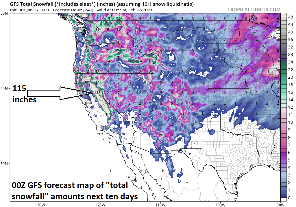
The Sierra Nevada Mountains of eastern California have been inundated by heavy snowfall in recent days and another ten feet or so can fall during the next ten days. Map courtesy NOAA, tropicaltidbits.com
This system now affecting California will push to the southeast over the next couple of days and then it’ll emerge over the Colorado Rockies early this weekend. From here, this low pressure system is liable to move northeast into the Central Plains and then I believe it will move over the Ohio River on its way to a position over the state of Ohio by Sunday afternoon or so – and this will likely be its most northward extent.

It is not just the California highlands that have received significant snow in recent days. A major snowstorm impacted the central Plains and Upper Midwest during the past couple of days and much snow fell as well in portions of the SW US (e.g., northern Arizona). Snow was even reported in Las Vegas (NV) this morning and Pasadena (CA) on Tuesday. In addition, the next 24-36 hours will feature accumulating snow in southwestern Virginia and northern North Carolina from an intensifying storm off the Carolina coastline. Maps courtesy BAMWX (left), NOAA, tropicaltidbits.com (right)
On Sunday night and Monday, this initial low pressure system over the Ohio Valley should weaken and give way to a developing storm near the Mid-Atlantic coastline and it is this second system will become the dominant player. The exact timing of the transfer of energy from the initial low to the secondary system and the speed at which the coastal storm intensifies and its ultimate track will play very important roles as to how much snow (and/or rain/ice) can fall in the DC-to-Philly-to-NYC corridor. It does appear increasingly likely that accumulating snow is a real threat in the Mid-Atlantic region during this upcoming winter storm. The potential is there for a long duration and significant event with overrunning precipitation on the front end and then “coastal storm generated” precipitation on the back end. There is a chance that some areas see a changeover from snow to rain and/or sleet during this event and this is something that would have an impact on ultimate snow accumulations.

I believe the GEM (Canadian) model has a good handle on the upcoming situation by placing the initial low pressure system over the Ohio River on Sunday night. This 12Z GEM surface forecast map features low pressure over the Ohio Valley and a secondary near the Mid-Atlantic coastline. Map courtesy Canadian Meteorological Centre, tropicaltidbits.com
Shortly after the second storm develops off the Mid-Atlantic coastline, it is likely to encounter a pretty strong blocking pattern in the part of the atmosphere over the eastern part of Canada and this will inhibit its movement to the north and east. In other words, we could be dealing with a long duration event in the Mid-Atlantic region. The precipitation time period from this second (coastal) system could extend all the way into later Tuesday and an influx of colder air on its back side could result in a change back to snow in those areas that do indeed turnover to rain and/or sleet earlier in the event.

A complex upper-level pattern as depicted by the 12Z Euro which will help to spawn a coastal low that will become the dominant player early next week. Map courtesy WSI, Inc., ECMWF
Stay tuned…lots of details to be ironed out in coming days for this complex and potentially significant winter storm.
Meteorologist Paul Dorian
Perspecta, Inc.
perspectaweather.com
Follow us on Facebook, Twitter, YouTube
Video discussion: